Country:
Region:
City:
Latitude and Longitude:
Time Zone:
Postal Code:
IP information under different IP Channel
ip-api
Country
Region
City
ASN
Time Zone
ISP
Blacklist
Proxy
Latitude
Longitude
Postal
Route
Luminati
Country
ASN
Time Zone
Europe/Paris
ISP
Zayo Infrastructure France SA
Latitude
Longitude
Postal
IPinfo
Country
Region
City
ASN
Time Zone
ISP
Blacklist
Proxy
Latitude
Longitude
Postal
Route
db-ip
Country
Region
City
ASN
Time Zone
ISP
Blacklist
Proxy
Latitude
Longitude
Postal
Route
ipdata
Country
Region
City
ASN
Time Zone
ISP
Blacklist
Proxy
Latitude
Longitude
Postal
Route
Popular places and events near this IP address

Montfermeil
Commune in Île-de-France, France
Distance: Approx. 2625 meters
Latitude and longitude: 48.9,2.5667
Montfermeil (French pronunciation: [mɔ̃fɛʁmɛj] ) is a commune in the eastern suburbs of Paris, France. It is located 17.2 km (10.7 mi) from the center of Paris. Montfermeil is famous as the location of Thénardiers' inn in Les Misérables.

Coubron
Commune in Île-de-France, France
Distance: Approx. 3005 meters
Latitude and longitude: 48.9167,2.5833
Coubron (French pronunciation: [ku'bʁɔ̃] ) is a commune in the Seine-Saint-Denis department, in the eastern suburbs of Paris, France. It is located 18.1 km (11.2 mi) from the center of Paris.

Chelles, Seine-et-Marne
Commune in Île-de-France, France
Distance: Approx. 992 meters
Latitude and longitude: 48.8833,2.6
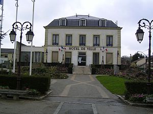
Chelles (French pronunciation: [ʃɛl] ) is a commune in the eastern suburbs of Paris, France. It is located in the Seine-et-Marne department in the Île-de-France region 18 km (11 mi) from the center of Paris.

Brou-sur-Chantereine
Commune in Île-de-France, France
Distance: Approx. 2562 meters
Latitude and longitude: 48.8817,2.6317
Brou-sur-Chantereine (French pronunciation: [bʁu syʁ ʃɑ̃tʁɛn] ) is a commune in the Seine-et-Marne department, in the Île-de-France region, north-central France.

Canton of Chelles
Canton in Île-de-France, France
Distance: Approx. 992 meters
Latitude and longitude: 48.8833,2.6
The canton of Chelles is a French administrative division, located in the arrondissement of Torcy, in the Seine-et-Marne département (Île-de-France région).
Canton of Vaires-sur-Marne
Former canton in Île-de-France, France
Distance: Approx. 2155 meters
Latitude and longitude: 48.87972222,2.62305556
The canton of Vaires-sur-Marne is a French former administrative division, located in the arrondissement of Torcy, in the Seine-et-Marne département (Île-de-France région). It was disbanded following the French canton reorganisation which came into effect in March 2015.

Courtry
Commune in Île-de-France, France
Distance: Approx. 2823 meters
Latitude and longitude: 48.9175,2.6031
Courtry (French pronunciation: [kuʁtʁi] ) is a commune in the Seine-et-Marne département in the Île-de-France region in north-central France.

Le Pin, Seine-et-Marne
Commune in Île-de-France, France
Distance: Approx. 3265 meters
Latitude and longitude: 48.9144,2.6297
Le Pin (French pronunciation: [lə pɛ̃] ) is a commune in the Seine-et-Marne department in the Île-de-France region in north-central France.
Communauté d'agglomération de Marne et Chantereine
Former communauté d'agglomération in Île-de-France, France
Distance: Approx. 1559 meters
Latitude and longitude: 48.8787,2.5949
The Communauté d'agglomération de Marne et Chantereine is a former federation of municipalities (communauté d'agglomération) in the Seine-et-Marne département and in the Île-de-France région of France. It was created in January 2009. It was merged into the Communauté d'agglomération Paris - Vallée de la Marne in January 2016.
Chelles Abbey
Frankish monastery
Distance: Approx. 1782 meters
Latitude and longitude: 48.87777778,2.59
Chelles Abbey (French: Abbaye Notre-Dame-des-Chelles) was a Frankish monastery founded around 657/660 during the early medieval period. It was intended initially as a monastery for women; then its reputation for great learning grew, and when men wanted to follow the monastic life, a parallel male community was established, creating a double monastery. The abbey stood in Chelles near Paris (Seine-et-Marne department) until it fell victim to the disestablishment of the Catholic Church in 1792 during the French Revolution and was dismantled.

Parc Arboretum de Montfermeil
Distance: Approx. 2311 meters
Latitude and longitude: 48.896631,2.569706
The Parc Arboretum de Montfermeil (10.9 hectares) is a park and arboretum located in Montfermeil, Seine-Saint-Denis, Île-de-France, France. It is open daily without charge. The park was formed by combining two existing parks, the former parc du Château des Cèdres and parc Jean Valjean, with extensive landscaping during which 731 trees and bushes were planted, adding to those 489 trees already in place.

Chelles–Gournay station
Railway station in Chelles, France
Distance: Approx. 2370 meters
Latitude and longitude: 48.87416667,2.58333333
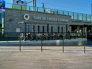
Chelles–Gournay is a railway station in Chelles, Seine-et-Marne, France. The station opened in 1849 and is on the Paris-Est–Strasbourg-Ville railway. The station is served by Transilien line P (East Paris) and RER Line E services operated by the SNCF. It will also see services operated by Grand Paris Express (Paris Metro Line 16) in the future.
Weather in this IP's area
broken clouds
9 Celsius
8 Celsius
8 Celsius
9 Celsius
1026 hPa
74 %
1026 hPa
1018 hPa
10000 meters
2.06 m/s
60 degree
75 %
07:59:18
17:09:26
