46.254.223.120 - IP Lookup: Free IP Address Lookup, Postal Code Lookup, IP Location Lookup, IP ASN, Public IP
Country:
 Russian Federation
Region:
City:
Location:
Time Zone:
Postal Code:
ISP:
ASN:
language:
User-Agent:
Proxy IP:
Blacklist:
IP information under different IP Channel
ip-api
Country
Region
City
ASN
Time Zone
ISP
Blacklist
Proxy
Latitude
Longitude
Postal
Route
db-ip
Country
Region
City
ASN
Time Zone
ISP
Blacklist
Proxy
Latitude
Longitude
Postal
Route
IPinfo
Country
Region
City
ASN
Time Zone
ISP
Blacklist
Proxy
Latitude
Longitude
Postal
Route
IP2Location
46.254.223.120Country
ruRegion
moskovskaya oblast'
City
ivanteyevka
Time Zone
Europe/Moscow
ISP
Language
User-Agent
Latitude
Longitude
Postal
ipdata
Country
Region
City
ASN
Time Zone
ISP
Blacklist
Proxy
Latitude
Longitude
Postal
Route
Popular places and events near this IP address
Shchyolkovo
City in Moscow Oblast, Russia
Distance: Approx. 7816 meters
Latitude and longitude: 55.91666667,38
Shchyolkovo (Russian: Щёлково, IPA: [ˈɕːɵlkəvə]) is a city and the administrative center of Shchyolkovsky District in Moscow Oblast, Russia, located on the Klyazma River (Oka's tributary), 20 kilometers (12 mi) northeast of Moscow. Population: 134,211 (2021 Census); 110,411 (2010 Census); 112,865 (2002 Census); 109,255 (1989 Census); 91,000 (1977).

Yubileyny, Moscow Oblast
Place in Moscow Oblast, Russia
Distance: Approx. 6095 meters
Latitude and longitude: 55.93333333,37.85
Yubileyny (Russian: Юбиле́йный) was a town in Moscow Oblast, Russia, located 7 kilometers (4.3 mi) northeast of the Moscow Ring Road by Yaroslavl Highway, on the Klyazma River. It was merged into the surrounding city of Korolyov effective June 2014. Population: 33,237 (2010 Census); 30,837 (2002 Census).
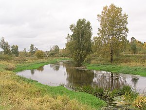
Ucha (river)
River in Russia
Distance: Approx. 4070 meters
Latitude and longitude: 55.9392,37.9527
The Ucha (Russian: Уча́) is a river in Moscow Oblast, Russia. It is a left tributary of the Klyazma. The construction of the Moscow Canal has separated the upper course of the Ucha from its lower course.

Russian State University of Tourism and Services Studies
Distance: Approx. 8199 meters
Latitude and longitude: 55.97,37.7892
Russian State University of Tourism and Service (RSUTS) is a public university in Russia and CIS countries which provides higher education in tourism and services studies. The university is based in Pushkino, Moscow Oblast, near Moscow, and has its own campus in Makhachkala. Originally a higher school of handicraft cooperation, it was founded in 1952.
Pushkinsky District, Moscow Oblast
District in Moscow Oblast, Russia
Distance: Approx. 6326 meters
Latitude and longitude: 56,37.83333333
Pushkinsky District (Russian: Пу́шкинский райо́н) is an administrative and municipal district (raion), one of the thirty-six in Moscow Oblast, Russia. It is located in the northern central part of the oblast. The area of the district is 571.47 square kilometers (220.65 sq mi).

Shchyolkovsky District
District in Moscow Oblast, Russia
Distance: Approx. 7105 meters
Latitude and longitude: 55.91694444,37.98111111
Shchyolkovsky District (Russian: Щёлковский райо́н) is an administrative and municipal district (raion), one of the thirty-six in Moscow Oblast, Russia. It is located in the northeast of the oblast. The area of the district is 704.88 square kilometers (272.16 sq mi).
Bolshevo
Town in Moscow Oblast, Russia
Distance: Approx. 6095 meters
Latitude and longitude: 55.93333333,37.85
Bolshevo (Russian: Бо́лшево) is the area of the city of Korolyov (an industrial city in Moscow Oblast, Russia, well known as the cradle of Soviet and Russian space exploration), the historical part of it. It was founded as an independent town in 1573. It is best known as giving the name of Bolshevo railway station which is located on Yaroslavsky suburban railway line, Moscow.
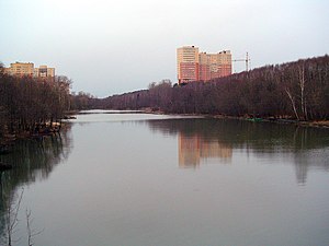
Serebryanka (Moscow Oblast)
River in Moscow Oblast, Russia
Distance: Approx. 4498 meters
Latitude and longitude: 55.99083333,37.85777778
The Serebryanka (Russian: Серебрянка) is a river in Moscow Oblast, Russia, a tributary of the Ucha. It flows through Pushkinsky District. The river starts in the village of Stepankovo and ends in Pushkino city, where it is confined by a levee near its mouth.

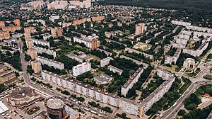
Ivanteyevka, Moscow Oblast
Town in Moscow Oblast, Russia
Distance: Approx. 1570 meters
Latitude and longitude: 55.98333333,37.93333333
Ivanteyevka (Russian: Иванте́евка) is a town in Moscow Oblast, Russia, located on the Ucha River 20 kilometers (12 mi) northeast of Moscow. Population: 82,827 (2021 Census); 58,626 (2010 Census); 51,454 (2002 Census); 53,140 (1989 Soviet census).

Pushkino, Pushkinsky District, Moscow Oblast
City in Moscow Oblast, Russia
Distance: Approx. 7442 meters
Latitude and longitude: 56.01666667,37.83333333
Pushkino (Russian: Пу́шкино, Russian pronunciation: [ˈpuʂkʲɪnə]) is a city and the administrative center of Pushkinsky District in Moscow Oblast, Russia, located at the confluence of the Ucha and Serebryanka Rivers, 30 kilometers (19 mi) northeast of Moscow. Population: 102,874 (2010 Census); 72,425 (2002 Census); 75,847 (1989 Soviet census); 57,000 (1974); 30,000 (1959); 21,000 (1939).

Zagoryansky
Urban-type settlement in Moscow Oblast, Russia
Distance: Approx. 5675 meters
Latitude and longitude: 55.9203,37.9285
Zagoryansky (Russian: Загорянский) is an urban locality (an urban-type settlement) in Shchyolkovsky District of Moscow Oblast, Russia. Population: 7,997 (2010 Census); 7,576 (2002 Census); 5,177 (1989 Soviet census).
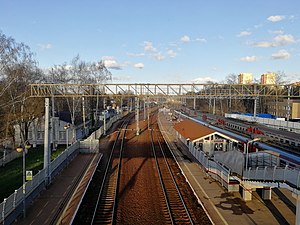
Bolshevo railway station
Railway station in Moscow Oblast, Russia
Distance: Approx. 6231 meters
Latitude and longitude: 55.9262,37.8611
Bolshevo railway station is a railway station in Moscow Oblast, Russia. It is located on the Mytishchi-Fryazino section of the Yaroslavsky suburban railway line. It is part of the Naukograd, or science city, of Korolyov.
Weather in this IP's area
scattered clouds
-7 Celsius
-7 Celsius
-7 Celsius
-7 Celsius
1020 hPa
100 %
1020 hPa
999 hPa
10000 meters
0.45 m/s
1.79 m/s
180 degree
47 %