Country:
 Finland
Region:
City:
Latitude and Longitude:
Time Zone:
Postal Code:
IP information under different IP Channel
ip-api
Country
Region
City
ASN
Time Zone
ISP
Blacklist
Proxy
Latitude
Longitude
Postal
Route
IPinfo
Country
Region
City
ASN
Time Zone
ISP
Blacklist
Proxy
Latitude
Longitude
Postal
Route
MaxMind
Country
Region
City
ASN
Time Zone
ISP
Blacklist
Proxy
Latitude
Longitude
Postal
Route
Luminati
Country
FIRegion
09
City
oulu
ASN
Time Zone
Europe/Helsinki
ISP
Cinia Oy
Latitude
Longitude
Postal
db-ip
Country
Region
City
ASN
Time Zone
ISP
Blacklist
Proxy
Latitude
Longitude
Postal
Route
ipdata
Country
Region
City
ASN
Time Zone
ISP
Blacklist
Proxy
Latitude
Longitude
Postal
Route
Popular places and events near this IP address

Kiiminki
Former municipality in Northern Ostrobothnia, Finland
Distance: Approx. 7222 meters
Latitude and longitude: 65.13333333,25.775
Kiiminki (Swedish: Kiminge) was a municipality of Finland. Along with Haukipudas, Oulunsalo and Yli-Ii municipalities it was merged with the city of Oulu on 1 January 2013. Kiiminki municipality was part of the Oulu province in the Northern Ostrobothnia region.

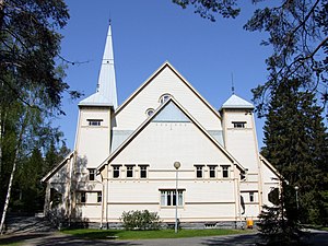
Kiiminki Church
Church in Oulu, Finland
Distance: Approx. 7059 meters
Latitude and longitude: 65.13555556,25.75861111
The Kiiminki Church (Finnish: Kiimingin kirkko, Swedish: Kiminge kyrka) is an evangelical Lutheran church in the Kiiminki district of the Finnish city of Oulu. It was part of the town of Kiiminki until 2013 when that town was merged into Oulu. The church building has been designed and constructed by Matti Honka, an Ostrobothnian builder of churches in the 18th century.

Haukipudas Church
Church in Oulu, Finland
Distance: Approx. 7059 meters
Latitude and longitude: 65.13555556,25.75861111
The Haukipudas Church is an evangelical Lutheran church in Haukipudas, Oulu. The church building was designed by Matti Honka, an Ostrobothnian builder of churches in the 18th century. The church was completed in 1762.

Kiiminki (district)
District of Oulu in Finland
Distance: Approx. 6827 meters
Latitude and longitude: 65.1289,25.7756
Kiiminki (Swedish: Kiminge) is a district of Oulu, Finland. Together with Alakylä, Hannus and Huttukylä districts, it forms the Kiiminki area. The center of the district is located where the National road 20 crosses the Kiiminkijoki river.
Oulujoki (municipality)
Former municipality in Oulu Province, Finland
Distance: Approx. 9983 meters
Latitude and longitude: 65.0072,25.5636
Oulujoki (formerly Oulun maalaiskunta or Oulu Rural Municipality) is a former municipality of Finland. The municipality had a population of 5,230 (1963) and covered a land area of 606.1 square kilometres (234.0 sq mi). Its neighbouring municipalities were Kempele, Kiiminki, Muhos, Oulu, Tyrnävä, Utajärvi and Ylikiiminki.

Koitelinkoski
Distance: Approx. 6241 meters
Latitude and longitude: 65.09944444,25.81555556
Koitelinkoski (i.e. Koiteli rapids) is an outdoor recreation area located along the Kiiminkijoki river in the Kiiminki district in Oulu, Finland. The area consists of small islands which divide the free-flowing river into smaller streams and rapids.
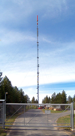
Oulu TV Mast
Distance: Approx. 8649 meters
Latitude and longitude: 65.03444444,25.84333333
Oulu TV Mast is a mast in the Huttukylä district in Oulu, Finland. The mast is also known as Kiiminki TV Mast as it is located in the area of the former Kiiminki municipality. The mast built in 1993 is 326 metres (1,070 ft) tall.
Weather in this IP's area
scattered clouds
15 Celsius
16 Celsius
15 Celsius
16 Celsius
1023 hPa
100 %
1023 hPa
1018 hPa
10000 meters
4.13 m/s
12.16 m/s
295 degree
40 %
06:54:31
19:26:45