Country:
 Iceland
Region:
City:
Latitude and Longitude:
Time Zone:
Postal Code:
IP information under different IP Channel
ip-api
Country
Region
City
ASN
Time Zone
ISP
Blacklist
Proxy
Latitude
Longitude
Postal
Route
IPinfo
Country
Region
City
ASN
Time Zone
ISP
Blacklist
Proxy
Latitude
Longitude
Postal
Route
MaxMind
Country
Region
City
ASN
Time Zone
ISP
Blacklist
Proxy
Latitude
Longitude
Postal
Route
Luminati
Country
ISRegion
1
City
kopavogur
ASN
Time Zone
Atlantic/Reykjavik
ISP
Ljosleidarinn ehf
Latitude
Longitude
Postal
db-ip
Country
Region
City
ASN
Time Zone
ISP
Blacklist
Proxy
Latitude
Longitude
Postal
Route
ipdata
Country
Region
City
ASN
Time Zone
ISP
Blacklist
Proxy
Latitude
Longitude
Postal
Route
Popular places and events near this IP address

Kópavogur
Municipality in Capital Region, Iceland
Distance: Approx. 1917 meters
Latitude and longitude: 64.11083333,-21.90944444
Kópavogur (Icelandic pronunciation: [ˈkʰouːpaˌvɔːɣʏr̥] ) is a town in Iceland that is the country's second largest municipality by population. It lies immediately south of Reykjavík and is part of the Capital Region. The name literally means seal pup inlet.
Kópavogur College
Distance: Approx. 1381 meters
Latitude and longitude: 64.11083333,-21.895
Kópavogur College (Icelandic: Menntaskólinn í Kópavogi Icelandic pronunciation: [ˈmɛn̥taˌskouːlɪn i ˈkʰouːpaˌvɔijɪ]) is an upper-secondary school in Kópavogur, Iceland, founded on September 22, 1973.
Smáralind
Icelandic shopping mall
Distance: Approx. 385 meters
Latitude and longitude: 64.10111111,-21.88416667
Smáralind (Icelandic pronunciation: [ˈsmauːraˌlɪnt]) is a shopping mall located in the Capital Region of Iceland. It is one of the biggest shopping malls in Iceland, with over ninety shops, restaurants and services. Designed by BDP and built by ÍSTAK, it was opened on 10 October 2001 at 10:10 GMT. Smáralind competes with other shopping centers of the Capital Region: Kringlan mall and Reykjavík's old city centre.

Kópavogskirkja
Church in Kópavogur, Iceland
Distance: Approx. 2160 meters
Latitude and longitude: 64.11222222,-21.91333333
Kópavogskirkja (Icelandic pronunciation: [ˈkʰouːpaˌvɔksˌcʰɪr̥ca]) is a church in Kópavogur, Iceland. It is located on Borgarholt hill at the top of Kársnes and offers a great view over Kópavogur, Reykjavík and surrounding area. Work on it began in 1958 and it was opened on December 16, 1963.

Kópavogsvöllur
Stadium in Kópavogur, Iceland
Distance: Approx. 1025 meters
Latitude and longitude: 64.10388889,-21.89666667
Kópavogsvöllur (Icelandic pronunciation: [ˈkʰouːpaˌvɔksˌvœtlʏr̥]) is a multi-use stadium in Kópavogur, Iceland. It is currently used mostly for football matches and is the home stadium of Breiðablik. It is also used for track and field events.
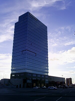
Smáratorg Tower
Office in Kópavogur, Iceland
Distance: Approx. 251 meters
Latitude and longitude: 64.10277778,-21.88055556
Smáratorg 3 (Icelandic pronunciation: [ˈsmauːraˌtʰɔrk]) is an office and retail building in Iceland. It is the tallest building in Iceland, surpassing Hallgrímskirkja in height, and is the fourth-tallest architectural structure in the country after the masts of Naval Radio Transmitter Facility in Grindavík and longwave radio mast at Hellissandur (which is the tallest longwave radio mast in the world). The building is located in Smárahverfi, Kópavogur, where the shopping mall Smáralind is also located.
Norðurturninn
Distance: Approx. 385 meters
Latitude and longitude: 64.10111111,-21.88416667
Norðurturninn (Icelandic pronunciation: [ˈnɔrðʏrˌtʰʏ(r)tnɪn], "the north tower"), is an office and retail building in Iceland completed in 2016. Norðurturninn is located in downtown Kópavogur, next to Smáratorg Tower and is connected to the shopping mall, Smáralind. Norðurturninn has 15 floors with a height of 62 metres (205 ft) at its completion.
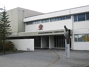
Breiðholt
District in Reykjavík, Iceland
Distance: Approx. 2254 meters
Latitude and longitude: 64.10777778,-21.83222222
Breiðholt (Icelandic pronunciation: [ˈpreiðˌhɔl̥t]) is a southeastern district of Reykjavík, Iceland. It includes three neighbourhoods: Neðra-Breiðholt [ˈnɛðra-ˌpreiðˌhɔl̥t] (Bakkar [ˈpahkar̥], Mjódd [ˈmjoutː] and Stekkir [ˈstɛhcɪr̥]), Efra-Breiðholt [ˈɛvra-ˌpreiðˌhɔl̥t] (Hólar [ˈhouːlar̥], Berg [ˈpɛrk] and Fell [ˈfɛtl̥]) and Seljahverfi [ˈsɛljaˌkʰvɛrvɪ] (Sel [ˈsɛːl̥]). It is one of the largest districts in Reykjavík, with a population of around 20,000.
Kórinn
Distance: Approx. 2138 meters
Latitude and longitude: 64.11222222,-21.91277778
Kórinn (Icelandic pronunciation: [ˈkʰouːrɪn]) is an indoor multipurpose auditorium located in Kópavogur and built in 2007. It includes an indoor football stadium which meets all the international standards set by the International Football Association FIFA. The auditorium covers an area of 14,457 m2 and has a seating capacity of 2000 spectators plus an additional 50 honor places. The auditorium is designed to accommodate concert acoustics and has a total standing capacity of up to 19,000 visitors.

Grímsbær
Distance: Approx. 2295 meters
Latitude and longitude: 64.122115,-21.875314
Grímsbær (Icelandic pronunciation: [ˈkrimsˌpaiːr̥]) is a small shopping centre in the middle of Reykjavík, Iceland. Originally a two-story structure built into a hillside, in 2004 a third floor was built on top of the existing structure and the centre grew to around 2000 m2, which it remains to this day.

Víkingsvöllur
Football stadium in Reykjavík, Iceland
Distance: Approx. 1951 meters
Latitude and longitude: 64.11638889,-21.85513889
Víkingsvöllur (Icelandic pronunciation: [ˈviːciŋsˌvœtlʏr̥]) is a football stadium in Reykjavík, Iceland.
Hertz-völlurinn
Stadium in Iceland
Distance: Approx. 1261 meters
Latitude and longitude: 64.104,-21.851
Hertz-völlurinn is a multi-use stadium in Reykjavík, Iceland. It is currently used mostly for football matches and is the home stadium of Íþróttafélag Reykjavíkur. Its capacity is around 1500.
Weather in this IP's area
clear sky
6 Celsius
4 Celsius
5 Celsius
6 Celsius
1021 hPa
47 %
1021 hPa
1018 hPa
10000 meters
2.57 m/s
340 degree
07:54:39
18:35:31