Country:
 Saudi Arabia
Region:
City:
Latitude and Longitude:
Time Zone:
Postal Code:
IP information under different IP Channel
ip-api
Country
Region
City
ASN
Time Zone
ISP
Blacklist
Proxy
Latitude
Longitude
Postal
Route
IPinfo
Country
Region
City
ASN
Time Zone
ISP
Blacklist
Proxy
Latitude
Longitude
Postal
Route
MaxMind
Country
Region
City
ASN
Time Zone
ISP
Blacklist
Proxy
Latitude
Longitude
Postal
Route
Luminati
Country
SARegion
02
City
jeddah
ASN
Time Zone
Asia/Riyadh
ISP
Nour Internet Company for Communications and Information Technology Ltd.
Latitude
Longitude
Postal
db-ip
Country
Region
City
ASN
Time Zone
ISP
Blacklist
Proxy
Latitude
Longitude
Postal
Route
ipdata
Country
Region
City
ASN
Time Zone
ISP
Blacklist
Proxy
Latitude
Longitude
Postal
Route
Popular places and events near this IP address
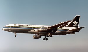
Saudia Flight 163
August 1980 aircraft fire in Riyadh, Saudi Arabia
Distance: Approx. 2795 meters
Latitude and longitude: 24.71166667,46.72694444
Saudia Flight 163 was a scheduled Saudia passenger flight departing from Quaid-e-Azam Airport in Karachi, Pakistan, bound for Kandara Airport in Jeddah, Saudi Arabia, via Riyadh International Airport in Riyadh, Saudi Arabia. The aircraft caught fire after takeoff from Riyadh International Airport (now the Riyadh Air Base) on 19 August 1980. Although the Lockheed L-1011-200 TriStar made a successful emergency landing at Riyadh, the flight crew failed to perform an emergency evacuation of the airplane, leading to the deaths of all 287 passengers and 14 crew on board the aircraft from smoke inhalation.

King Fahd Medical City
Hospital in Riyadh, Saudi Arabia
Distance: Approx. 1733 meters
Latitude and longitude: 24.6875,46.70527778
King Fahd Medical City (KFMC) is a medical complex in Riyadh, Saudi Arabia. It consists of four hospitals: The Obstetrics & Gynecology Hospital, The Specialist Hospital, The Rehabilitation Hospital, and The Pediatric Hospital. It was built at a cost of $633 million.
King Salman Air Base
Airport in Riyadh, Saudi Arabia
Distance: Approx. 2557 meters
Latitude and longitude: 24.70972222,46.72527778
King Salman Air Base (ICAO: OERY, Arabic: قاعدة الملك سلمان الجوية), formerly known as Riyadh Air Base until 2015 with the commencement of "Decisive Storm" and formerly known as Riyadh International Airport from its opening in 1946 until 1983, was a military air base in Riyadh, Saudi Arabia. It was originally used by Saudia as an airline hub before King Khalid International Airport opened in 1983.
Bangladesh International School, English Section, Riyadh
International school
Distance: Approx. 2461 meters
Latitude and longitude: 24.6846,46.6982
Bangladesh International School, English Section, Riyadh (BISES, Riyadh) is a school located in the Olaya district of Riyadh, Saudi Arabia. It follows the British Curriculum.
Riyadh Military Hospital
Hospital in Riyadh, Saudi Arabia
Distance: Approx. 2300 meters
Latitude and longitude: 24.68333333,46.7
Prince Sultan Military Medical City (PSMMC) also known as Riyadh Armed Forces Hospital is located in Riyadh City, the capital of Saudi Arabia, considered one of the most advanced centres in the Middle East. It is located in the heart of Riyadh. At a distance of approximately 20 kilometres (12 mi) from the city centre and easily accessible to the general population.

King Abdullah Park, Riyadh
Public park in Riyadh, Saudi Arabia
Distance: Approx. 2716 meters
Latitude and longitude: 24.66638889,46.73694444
King Abdullah Park (Arabic: ﻣﻨﺘﺰﻩ ﺍﻟﻤﻠﻚ ﻋﺒﺪﺍﷲ, romanized: Muntazah al-Malik ʿAbd Allāh), formerly Al-Malaz Square (Arabic: ميدان الملز), is an equestrian field-turned municipal park in the al-Malazz neighborhood of Riyadh, Saudi Arabia, located adjacent to Prince Faisal bin Fahd Stadium. Covering an area of 31.8 hectares (79 acres), the square served as a horse racecourse from the early 20th century until 2002, before being reopened as the largest public park in the country in 2013. Al-Malaz Square, as it was previously called, lent its name to the al-Malazz neighbourhood, which the park today forms a central part of.

Shola Shopping Center
Defunct shopping mall in Riyadh, Saudi Arabia
Distance: Approx. 1223 meters
Latitude and longitude: 24.67638889,46.71888889
Shola Shopping Center (Arabic: مركز الشعلة التجاري, romanized: Markaz al-Šuʿalah al-Tiǧārī) was a shopping complex in the ad-Dhubbat neighborhood of Riyadh, Saudi Arabia. Popular for its gold markets, it was one of the oldest shopping centers in the country's capital at the time of its launch in 1984. The complex was permanently closed in the aftermath of a fire-breakout in November 2012.
Al Malazz
Neighbourhood in Riyadh, Saudi Arabia
Distance: Approx. 2791 meters
Latitude and longitude: 24.66472222,46.73527778
Al-Malazz (Arabic: حي الملز, romanized: ḥaī al-Malaz), formerly al-Riyadh al-Jadidah (lit. The New Riyadh) and the Red Sea neighborhood, is a commercial and residential neighborhood and the seat of the sub-municipality of its namesake, al-Malaz, in downtown Riyadh, Saudi Arabia. Named after the al-Malaz Square (now King Abdullah Park), it was built between 1954 and 1957 by King Saud bin Abdulaziz as a housing project for government employees and was later developed into a full-fledged district.
International Indian Public School Riyadh
Private school in As-Sulaimaniyah, Riyadh, Saudi Arabia
Distance: Approx. 1841 meters
Latitude and longitude: 24.69083333,46.70472222
International Indian Public School Riyadh (IIPS-R), formerly SEVA School is a K–12 gender-isolated English-medium community-based international school in as-Sulaimaniyah, Riyadh, Saudi Arabia. Established in 1995, it primarily serves the Indian diaspora of the city and provides Indian curriculum prescribed by the Central Board of Secondary Education. It is a member of the CBSE Gulf Sahodaya and is approved by the Ministry of Education, Government of Saudi Arabia.
Al Yasmin International School
Private school in Al Malazz, Riyadh , Saudi Arabia
Distance: Approx. 3160 meters
Latitude and longitude: 24.66583333,46.74333333
Al-Yasmin International School (AYIS) (Arabic: مدرسة الیاسمین العالمية, romanized: Madrasah al-Yāsmīn al-ʿĀlamīyah; Malayalam: അൽ യാസ്മിൻ ഇന്റർനാഷണൽ സ്കൂൾ, romanized: al-Yāsmin Inṟarnāṣaṇal Skūḷ) is a K–12 gender-isolated English-medium community-based foreign school in the al-Malazz neighborhood of Riyadh, Saudi Arabia. Established in 1999, the school offers Indian curriculum prescribed by the Central Board of Secondary Education and primarily serves the Indian diaspora. Founded in 1999 by Indian politician and businessman PV Abdul Wahab, it offers Indian curriculum prescribed by the Central Board of Secondary Education and is a member of the CBSE Gulf Sahodaya.

Al Wazarat
Neighbourhood in central Riyadh, Saudi Arabia
Distance: Approx. 2215 meters
Latitude and longitude: 24.67,46.71083333
Haara al-Wazarat (Arabic: حارة الوزارات, lit. 'the ministries quarter'), or Hayy al-Wazarat (Arabic: حي الوزارات, lit. 'the ministries neighborhood'), colloquially known as Hara (Arabic: حارة, lit. 'quarter'), is a low-income residential neighborhood in central Riyadh, Saudi Arabia, located west of al-Dhubbat and south of al-Sulaimaniyah in the sub-municipality of al-Malaz. It was developed in the 1970s and hosts some of the country's government buildings, most notably the offices of the Ministry of Defense and the Royal Saudi Navy. It is the heart of the city's Indian Hyderabadi Muslim community and has also been overwhelmingly inhabited by overseas workers from Pakistan and Bangladesh since the 1980s.

Jabal Abu Makhruq
Distance: Approx. 1544 meters
Latitude and longitude: 24.67333333,46.72555556
Jabal Abu Makhruq (Arabic: جبل أبو مخروق), or in Najdi vernacular pronunciation as Jabal Abo Makhrog and popularly known as Camel's Eye (Arabic: عين الجمل), is a conical limestone hill with a natural arch through it in the ad-Dhubbat neighborhood of Riyadh, Saudi Arabia. With an elevation of approximately 50 meters, it is so named for a 7 to 8 meters wide, almost oval hole through the top of the hill that was formed due to erosion. It was mentioned in Yaqut al-Hamawi's 13th century work Kitāb Mu'jam al-Buldān as Jabal Kharba (Arabic: جبل الخربة) and was once a stopover for caravans arriving from Eastern Arabia en route to the walled town of Riyadh.
Weather in this IP's area
clear sky
29 Celsius
28 Celsius
29 Celsius
29 Celsius
1009 hPa
26 %
1009 hPa
942 hPa
10000 meters
2.48 m/s
3.24 m/s
99 degree
05:41:05
17:51:59