46.235.211.10 - IP Lookup: Free IP Address Lookup, Postal Code Lookup, IP Location Lookup, IP ASN, Public IP
Country:
Region:
City:
Location:
Time Zone:
Postal Code:
ISP:
ASN:
language:
User-Agent:
Proxy IP:
Blacklist:
IP information under different IP Channel
ip-api
Country
Region
City
ASN
Time Zone
ISP
Blacklist
Proxy
Latitude
Longitude
Postal
Route
db-ip
Country
Region
City
ASN
Time Zone
ISP
Blacklist
Proxy
Latitude
Longitude
Postal
Route
IPinfo
Country
Region
City
ASN
Time Zone
ISP
Blacklist
Proxy
Latitude
Longitude
Postal
Route
IP2Location
46.235.211.10Country
Region
al janubiyah
City
'ayn ad dar
Time Zone
Asia/Bahrain
ISP
Language
User-Agent
Latitude
Longitude
Postal
ipdata
Country
Region
City
ASN
Time Zone
ISP
Blacklist
Proxy
Latitude
Longitude
Postal
Route
Popular places and events near this IP address
Jidhafs
City in Northern Governorate, Bahrain
Distance: Approx. 535 meters
Latitude and longitude: 26.219,50.538
Jidhafs (Arabic: جدحفص, romanized: Jid Ḥafṣ) is a city in Bahrain. It was a municipality of Bahrain in the northern part of the country. Its territory is now in the Capital and Northern Governorate.

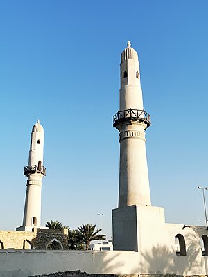
Khamis Mosque
Mosque in Khamis, Manama, Bahrain
Distance: Approx. 1772 meters
Latitude and longitude: 26.2082,50.5483
The Khamis Mosque (Arabic: مَسْجِدُ ٱلْخَمِيسِ; transliterated: Masǧid al-ḫamīs) is believed to be the first mosque in Bahrain, built during the era of the Umayyad caliph Umar II. According to Al Wasat journalist Kassim Hussain, other sources mention that it was built in a later era during the rule of Uyunids with one minaret. The second was built two centuries later during the rule of Usfurids. The identical twin minarets of this ancient Islamic monument make it easily noticeable as one drives along the Shaikh Salman Road in Khamis.
Al Daih
Village in Bahrain
Distance: Approx. 5 meters
Latitude and longitude: 26.21666667,50.53333333
Al Daih (Arabic: الديه, Persian: دِه/ديه, romanized: deh) is a village on the north of Bahrain. It lies to the east of Budaiya, west of Al Manama.

International Hospital of Bahrain
Hospital in Jidhafs, Bahrain
Distance: Approx. 743 meters
Latitude and longitude: 26.21916667,50.52638889
The International Hospital of Bahrain (Abbreviation: IHB; Arabic: مستشفى البحرين الدولي ) was a private hospital in the Kingdom of Bahrain. Established in 1978 and located in Jidhafs, off the Budaiya highway, it was the second private medical center in the country after the American Mission Hospital. In 2014, a dispute emerged over unpaid wages to nurses and doctors after the hospital had an 80% decrease in patient visits.
Ibn Al Hytham Islamic School
Private school in Manama, Bahrain
Distance: Approx. 1699 meters
Latitude and longitude: 26.22555556,50.51944444
Ibn-Al-Hytham Islamic School is a government-recognised expatriate institution in the Kingdom of Bahrain catering to education while adhering to the tenets of Islam. Islamic ideology guides the school in all aspects of its activities. It has 250 teachers and more than 2500 students.
Muqsha
Distance: Approx. 1889 meters
Latitude and longitude: 26.221,50.515
Muqsha (Arabic: المقشع، al-Muqsha) is a village in Bahrain and is situated west of the capital Manama. It is also located in Budaiya Highway, where it is located in the northern part of the highway which separates it from the village of Qadam, south of Muqsha. Muqsha also borders the villages of Al-Hilla, Karbabad, Al-Qalaa to the north, Karranah to the west, and Jidhafs to the east.

Sehla
Village in Northern Governorate, Bahrain
Distance: Approx. 1638 meters
Latitude and longitude: 26.202,50.534
Sehla (Arabic:سهلة) is a village located in the north of Bahrain, on the outskirts of the capital city Manama. It is located in the Northern Governorate administrative region and is west of Khamis. The village is divided into two sections; North Sehla and South Sehla.
Tashan, Bahrain
Village in Bahrain
Distance: Approx. 1471 meters
Latitude and longitude: 26.21,50.546
Tashan (Arabic:طشان) is a village located in the Kingdom of Bahrain, on the western outskirts of the capital city Manama. It is a village adjacent to Bilad Al Qadeem but significantly smaller.
Karbabad
Village in the Kingdom of Bahrain
Distance: Approx. 1852 meters
Latitude and longitude: 26.23333333,50.53333333
Karbabad (Arabic: كرباباد) is a village situated in the northern part of the Kingdom of Bahrain, along the northern coastline bordering the Persian Gulf. The village is famously known for being close to the location of the UNESCO World Heritage Site Qal'at al-Bahrain. The village was known for its beach, however in recent years, land reclamation has resulted in the once sea-front village to be up to 2 km inwards.
Al Musalla
Village in Northern Governorate, Bahrain
Distance: Approx. 5 meters
Latitude and longitude: 26.21666667,50.53333333
Al Musalla (Arabic: المصلى) is a village situated in the northern region of the Kingdom of Bahrain, on the western outskirts of the capital city Manama. The villages lies under the Northern Governorate administrative region. The villages lies west of the village of Tashan and Khamis and north of Sehla.

Al Qadam
Distance: Approx. 1661 meters
Latitude and longitude: 26.21666667,50.51666667
Al Qadam is a village in the northern region of the Kingdom of Bahrain.
Al Hajar, Bahrain
Distance: Approx. 1661 meters
Latitude and longitude: 26.21666667,50.51666667
Al Hajar (Arabic: الحجر) is a village in the northern region of the Kingdom of Bahrain, west of the village of Al Qadam and lines the Budaiya highway.
Weather in this IP's area
scattered clouds
17 Celsius
17 Celsius
17 Celsius
17 Celsius
1022 hPa
53 %
1022 hPa
1022 hPa
10000 meters
2.58 m/s
2.84 m/s
280 degree
39 %