Country:
Region:
City:
Latitude and Longitude:
Time Zone:
Postal Code:
IP information under different IP Channel
ip-api
Country
Region
City
ASN
Time Zone
ISP
Blacklist
Proxy
Latitude
Longitude
Postal
Route
Luminati
Country
Region
idf
City
saintcloud
ASN
Time Zone
Europe/Paris
ISP
Outscale SASU
Latitude
Longitude
Postal
IPinfo
Country
Region
City
ASN
Time Zone
ISP
Blacklist
Proxy
Latitude
Longitude
Postal
Route
db-ip
Country
Region
City
ASN
Time Zone
ISP
Blacklist
Proxy
Latitude
Longitude
Postal
Route
ipdata
Country
Region
City
ASN
Time Zone
ISP
Blacklist
Proxy
Latitude
Longitude
Postal
Route
Popular places and events near this IP address

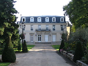
Garches
Commune in Île-de-France, France
Distance: Approx. 1186 meters
Latitude and longitude: 48.8461,2.1889
Garches (French pronunciation: [ɡaʁʃ] ) is a commune in the western suburbs of Paris, France. It is located 11.9 km (7.4 mi) from the centre of Paris. Garches has remained largely residential, with a population of 17,898 as of 2021, but is also the location of Raymond Poincaré University Hospital, which specialises in traumatology, road accidents and physiotherapy.

Château de Saint-Cloud
Former royal palace in France, today a national park
Distance: Approx. 1451 meters
Latitude and longitude: 48.8375,2.21472222
The Château de Saint-Cloud (French pronunciation: [ʃato d(ə) sɛ̃ klu]) was a château in France, built on a site overlooking the Seine at Saint-Cloud in Hauts-de-Seine, about 5 kilometres (3 miles) west of Paris. On the site of the former palace is the state-owned Parc de Saint-Cloud. The château was expanded by Philippe I, Duke of Orléans in the 17th century, and by Marie Antoinette in the 1780s.

Saint-Cloud Racecourse
Distance: Approx. 927 meters
Latitude and longitude: 48.85694444,2.20277778
Hippodrome de Saint-Cloud is a grass race course for Thoroughbred flat horse racing opened in 1901 at 1 rue du Camp Canadien in Saint-Cloud near Paris, France. During World War 1, the race course site housed the No. 4 Canadian Stationary Hospital operated by the Canadian Army Medical Corp.
Île-de-France tramway Line 2
Tram line in Paris, Hauts-de-Seine and Val-d'Oise
Distance: Approx. 1412 meters
Latitude and longitude: 48.8431,2.2219
Île-de-France tramway Line 2 (T2; French: Ligne 2 du tramway d'Île-de-France) is part of the modern tram network of the Île-de-France region of France. It connects the commune of Bezons in the north to the Porte de Versailles Métro station in Paris in the south, serving Hauts-de-Seine and its La Défense business district. The line has been operated by the RATP Group since its opening, under the authority of Île-de-France Mobilités.
American School of Paris
International school in France
Distance: Approx. 1096 meters
Latitude and longitude: 48.8406,2.1961
The American School of Paris (ASP), established in 1946, is a coeducational, independent international school in Saint-Cloud, France, in the Paris metropolitan area. The school has over 800 students from pre-kindergarten to Grade 12 and post-Bac. Located on a private 10.5 acre (40,000+ m2) campus on the edge of Paris, ASP provides an American education to an international student body of more than 50 nationalities.

Parc de Saint-Cloud
French national estate in Greater Paris
Distance: Approx. 1451 meters
Latitude and longitude: 48.8375,2.21472222
The Parc de Saint-Cloud (pronounced [paʁk də sɛ̃ klu]; Park of Saint-Cloud), officially the Domaine national de Saint-Cloud (pronounced [dɔmɛn nɑsjɔnal də sɛ̃ klu]; National Estate of Saint-Cloud), is a domaine national (national estate) located mostly within the Saint-Cloud commune, in the Hauts-de-Seine department, southwest of Paris, France. The park, which covers 460 hectares (1,100 acres), was a nature reserve on the left bank of the Seine until 1923. It was centred around the former Château de Saint-Cloud, home of Philippe I, Duke of Orléans (1640–1701), which was destroyed by French bombing in 1870 during the Franco-Prussian War after the Prussians had made a base of it.

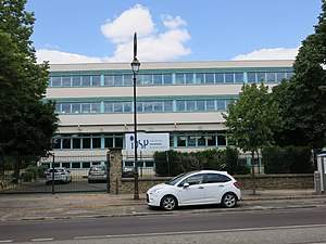
Internationale Deutsche Schule Paris
German international school in France
Distance: Approx. 716 meters
Latitude and longitude: 48.8423042,2.2035179
Internationale Deutsche Schule Paris (iDSP; French: École Allemande Internationale de Paris) is a German international school in Saint-Cloud, France, in the Paris metropolitan area. The school serves levels kindergarten through Sekundarstufe II. On 23 October 1958 the first stone for the school was laid. On 3 November of that year the school first opened in three YMCA-owned rooms in the 16th arrondissement of Paris, in proximity to Trocadéro.

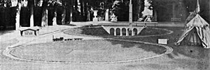
Railway of the Prince Imperial
First documented model railway
Distance: Approx. 1443 meters
Latitude and longitude: 48.8371,2.2134
The railway of the Prince Imperial (French: Chemin de fer du Prince impérial) was the first documented model railway in the world.
Canton of Saint-Cloud
Administrative division of Hauts-de-Seine, France
Distance: Approx. 1046 meters
Latitude and longitude: 48.84,2.21
The canton of Saint-Cloud is an administrative division of the Hauts-de-Seine department in northern France. Its borders were modified at the French canton reorganisation which came into effect in March 2015. Its seat is in Saint-Cloud.
René Huguenin Hospital
Hospital in Île-de-France, France
Distance: Approx. 1055 meters
Latitude and longitude: 48.8447941,2.217725
The René Huguenin Hospital is a renowned teaching hospital in Saint-Cloud, France. Part of the Curie Institute and a teaching hospital of Versailles Saint-Quentin-en-Yvelines University. Established in 2010, it was named in honour of René Huguenin (1894–1955), oncologist, Professor of Pathology and a former director of the Institut Gustave Roussy.
Golf de Saint-Cloud
Golf course in France
Distance: Approx. 1257 meters
Latitude and longitude: 48.8526,2.1885
Golf de Saint-Cloud is a 36-hole golf complex located in the parishes of Garches, Rueil-Malmaison and Vaucresson, 12 km west of central Paris, France.

Val d'Or train station
Train station in France
Distance: Approx. 1272 meters
Latitude and longitude: 48.8569,2.2167
The Val d'Or train station is a station on the railway line from Paris-Saint-Lazare to Versailles-Rive-Droite, located in the commune of Saint-Cloud, in the Hauts-de-Seine department of the Île-de-France region. In 1903, the Compagnie des chemins de fer de l'Ouest launched a halt to serve the Fouilleuse racecourse (now the Saint-Cloud racecourse). The halt took on its current name and configuration in 1911 when it became a station.
Weather in this IP's area
mist
7 Celsius
5 Celsius
6 Celsius
8 Celsius
1025 hPa
98 %
1025 hPa
1010 hPa
4000 meters
3.09 m/s
80 degree
100 %
07:49:39
17:20:18

