Country:
Region:
City:
Latitude and Longitude:
Time Zone:
Postal Code:
IP information under different IP Channel
ip-api
Country
Region
City
ASN
Time Zone
ISP
Blacklist
Proxy
Latitude
Longitude
Postal
Route
Luminati
Country
ASN
Time Zone
America/Chicago
ISP
LLNW
Latitude
Longitude
Postal
IPinfo
Country
Region
City
ASN
Time Zone
ISP
Blacklist
Proxy
Latitude
Longitude
Postal
Route
db-ip
Country
Region
City
ASN
Time Zone
ISP
Blacklist
Proxy
Latitude
Longitude
Postal
Route
ipdata
Country
Region
City
ASN
Time Zone
ISP
Blacklist
Proxy
Latitude
Longitude
Postal
Route
Popular places and events near this IP address
Matza restaurant suicide bombing
2002 Palestinian militant attack in Haifa, Israel
Distance: Approx. 1348 meters
Latitude and longitude: 32.78861111,35.0025
The Matza restaurant suicide bombing occurred on March 31, 2002, when a Palestinian Hamas suicide bomber detonated his bomb inside the Matza restaurant in Haifa, Israel, near the Grand Canyon shopping mall, killing 16 Israeli civilians including children and injuring over 40 people.

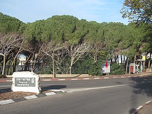
Vardiya
Distance: Approx. 704 meters
Latitude and longitude: 32.79376667,34.99711944
Vardiya (Hebrew: ורדיה, also Vardia) is a neighborhood in Haifa, Israel. Established in the 1980s, Vardiya is located in the upper Carmel, between the Hadar Hacarmel and Romema. The pine forests ringing the neighborhood were once a popular site for family recreation and hiking.

Romema (Haifa)
Distance: Approx. 952 meters
Latitude and longitude: 32.78687778,34.99523333
Romema (Hebrew: רוממה) is a neighborhood in the city of Haifa, Israel. Also known as The Romemot and Ramat Ben-Gurion, it is located east of Ahuza, on the northern slope of Mount Carmel. Today the neighborhood has two sections - New Romema and Old Romema - with a joint population of 8,340.

Haifa bus 37 suicide bombing
2003 terrorist attack by Palestinian militants in Haifa, Israel
Distance: Approx. 622 meters
Latitude and longitude: 32.79722222,34.98416667
The Haifa bus 37 suicide bombing was a Palestinian suicide bombing carried out on 5 March 2003 on an Egged bus in Haifa, Israel. 17 passengers were killed in the attack and 53 were injured. Many of the victims were children, teenagers and students from Haifa University.

Hebrew Reali School
Private school in Haifa, Israel
Distance: Approx. 438 meters
Latitude and longitude: 32.79029722,34.99118611
The Hebrew Reali School of Haifa (Hebrew: בֵּית־הַסֵּפֶר הָרֵיאָלִי הָעִבְרִי בְחֵיפָה, romanized: Bet ha-sefer ha-Reali ha‘Ivri be-Ḥeifa), located in Haifa, Israel, is one of the country's oldest private schools.
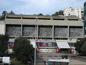
Romema Arena
Multi-purpose arena in Haifa, Israel
Distance: Approx. 993 meters
Latitude and longitude: 32.78767222,34.99707778
The Romema Arena (Hebrew: היכל הספורט העירוני רוממה) is a multi-purpose arena in Haifa, Israel. The arena is home to Hapoel Haifa basketball club and to Maccabi Haifa basketball club, a members of both the Hapoel Haifa and Maccabi Haifa sports clubs. The arena was and is a home to various entertainment events, conventions, and major events in other sports.
Haifa Cinematheque
Distance: Approx. 1121 meters
Latitude and longitude: 32.80336,34.98518
Haifa Cinematheque is a cinematheque located in Haifa at the Auditorium of Haifa in the Carmel Cente.
Fall of Haifa (1265)
Successful Mamluk siege against the Crusaders
Distance: Approx. 891 meters
Latitude and longitude: 32.8,34.9833
In 1265, the army of Baibars the Mamluk captured Haifa, destroying its fortifications, which had been rebuilt by Louis IX of France, as well as the majority of the city's homes to prevent the European Crusaders from returning.
Gan HaEm
Distance: Approx. 1316 meters
Latitude and longitude: 32.8056,34.9869
Gan HaEm ("Mother's Garden") is a public garden in Haifa, Israel. The garden is located in the Carmel Center neighborhood, near the upper station of the Carmelit. Nearby is Haifa Zoo, the Biological Institute, and the Lotem River.
Merkaz HaCarmel
Distance: Approx. 1316 meters
Latitude and longitude: 32.8056,34.9869
Merkaz HaCarmel (Hebrew: מרכז הכרמל) also called Carmel Merkazi (Hebrew: כרמל מרכזי) or in English, Carmel Center, is a neighborhood, and cultural and recreation area on the slopes of Mount Carmel in Haifa, Israel.

Elisha Medical Center
Hospital in Haifa, Israel
Distance: Approx. 799 meters
Latitude and longitude: 32.80083333,34.99222222
The Elisha Medical Center, also called Elisha Hospital (Hebrew: בית חולים אלישע) is a private hospital in Haifa, northern Israel. The center offers its patients physicians, technology and equipment, to provide the patients medical treatment. In order to expand its services and reach a broader patient population, the hospital has collaborated with the Rambam Medical Center.
Carmel Medical Center
Hospital in Haifa, Israel
Distance: Approx. 1214 meters
Latitude and longitude: 32.786356,34.980353
Carmel Medical Center (Hebrew: מרכז רפואי כרמל, romanized: Merkaz Refoí Camrel; formerly Carmel Hospital) is a hospital located in the Ahuzat Shmuel neighborhood in Haifa, Israel. The hospital belongs to Clalit Health Services.
Weather in this IP's area
few clouds
18 Celsius
18 Celsius
18 Celsius
22 Celsius
1019 hPa
79 %
1019 hPa
989 hPa
10000 meters
3.3 m/s
3.58 m/s
33 degree
17 %
06:04:07
16:43:33


