46.227.116.24 - IP Lookup: Free IP Address Lookup, Postal Code Lookup, IP Location Lookup, IP ASN, Public IP
Country:
Region:
City:
Location:
Time Zone:
Postal Code:
ISP:
ASN:
language:
User-Agent:
Proxy IP:
Blacklist:
IP information under different IP Channel
ip-api
Country
Region
City
ASN
Time Zone
ISP
Blacklist
Proxy
Latitude
Longitude
Postal
Route
db-ip
Country
Region
City
ASN
Time Zone
ISP
Blacklist
Proxy
Latitude
Longitude
Postal
Route
IPinfo
Country
Region
City
ASN
Time Zone
ISP
Blacklist
Proxy
Latitude
Longitude
Postal
Route
IP2Location
46.227.116.24Country
Region
streymoy
City
vestmanna
Time Zone
Atlantic/Faroe
ISP
Language
User-Agent
Latitude
Longitude
Postal
ipdata
Country
Region
City
ASN
Time Zone
ISP
Blacklist
Proxy
Latitude
Longitude
Postal
Route
Popular places and events near this IP address

Hvalvík
Village in Faroe Islands, Kingdom of Denmark
Distance: Approx. 7962 meters
Latitude and longitude: 62.18972222,-7.03083333
Hvalvík (Danish: Kvalvig) is a village in the Faroe Islands, located in a valley on the east coast of the island of Streymoy. It is the southern half of a twin-village situated on both sides of the valley. The villages are divided by the river Stórá.

Fjallavatn
Lake in the Faroe Islands
Distance: Approx. 7870 meters
Latitude and longitude: 62.1225,-7.29916667
Fjallavatn is the second largest lake in the Faroe Islands. It is situated on the island of Vágar and its size is 1 km2.
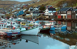
Vestmanna
Municipality and village in Faroe Islands, Kingdom of Denmark
Distance: Approx. 1 meters
Latitude and longitude: 62.15638889,-7.16638889
Vestmanna is a town in the Faroe Islands on the west of the island of Streymoy. It was formerly a ferry port, until an undersea tunnel, the Vágatunnilin, was built from Vágar to Kvívík and Stykkið further south on Streymoy. The cliffs west of Vestmanna, Vestmannabjørgini, are very popular for excursions by boat.

Slættanes
Abandoned village in Faroe Islands, Kingdom of Denmark
Distance: Approx. 3553 meters
Latitude and longitude: 62.15,-7.23333333
Slættanes (pronounced [ˈslaʰtːaˌneːs]) is a village on the island of Vágar in the western Faroes, which is now abandoned and only used as summer homes. Slættanes, like the also-abandoned village of Víkar, is on the northern coast of the island. It was founded in 1835 by a man named Hendrik Thomasen and belonged to the municipality of Sandavágur in the south.

Kvívík
Municipality and village in Faroe Islands, Kingdom of Denmark
Distance: Approx. 6500 meters
Latitude and longitude: 62.12055556,-7.06777778
Kvívík (Danish: Kvivig) is a village and municipality on the west coast of Streymoy in the Faroe Islands.
Válur
Village in Faroe Islands, Kingdom of Denmark
Distance: Approx. 32 meters
Latitude and longitude: 62.15611111,-7.16638889
Válur (Danish: Vålen) is a village on the Faroese island of Streymoy located in Kvívík Municipality. Its population is 49 (2015). Its postal code is FO 358.
Streymnes
Village in Faroe Islands, Kingdom of Denmark
Distance: Approx. 7951 meters
Latitude and longitude: 62.19166667,-7.03333333
Streymnes (Danish: Strømnæs) is a village on the eastern coast of the Faroese island of Streymoy in Sunda Municipality. The 2015 population was 270. Its postal code is FO 435.
Stykkið
Village in Faroe Islands, Kingdom of Denmark
Distance: Approx. 7593 meters
Latitude and longitude: 62.11666667,-7.04777778
Stykkið (Danish: Stykket) is a village on the west coast of the Faroese island Streymoy in Kvívík Municipality. The 2005 population was 42. Its postal code is FO 330.

Vágatunnilin
Undersea road tunnel in the Faroe Islands
Distance: Approx. 6848 meters
Latitude and longitude: 62.11,-7.08
The Vágatunnilin (Vágar Tunnel) is a 4,940 metres (16,210 ft) long undersea road tunnel in the Faroe Islands. It goes under Vestmannasund strait and connects the two islands of Streymoy and Vágar. The tunnel was the first sub-sea tunnel in the Faroe Islands, and connects the capital of Tórshavn on Streymoy with Vágar Airport on Vágar.

Við Margáir
Distance: Approx. 7659 meters
Latitude and longitude: 62.1941,-7.0431
Við Margáir is a stadium in Streymnes, Faroe Islands. It is currently used mostly for association football matches and is the home ground of EB/Streymur.

Frammi við Gjónna
Village in Faroe Islands, Kingdom of Denmark
Distance: Approx. 7825 meters
Latitude and longitude: 62.1366,-7.02203889
Frammi við Gjónna is an abandoned village in the Faroe Islands. A farm was established in the village as a settlement village in 1815, but there was probably already settlement at the site even earlier. The farm is located next to some streams near Lake Leynar in the Municipality of Kvívík on Streymoy.

KOKS (restaurant)
Restaurant located in Leynavatn, in the Faroe Islands
Distance: Approx. 7786 meters
Latitude and longitude: 62.1367513,-7.0227216
KOKS is a restaurant located in Leynavatn, located 24 km north of Tórshavn and 23 km east of the airport in the Faroe Islands. It offers a 17-course tasting menu and won its first Michelin star in 2017. KOKS’ head chef is Poul Andrias Ziska, a 28-year-old chef and native of Tórshavn.
Weather in this IP's area
broken clouds
7 Celsius
2 Celsius
7 Celsius
7 Celsius
1028 hPa
81 %
1028 hPa
1010 hPa
10000 meters
8.75 m/s
170 degree
75 %
