Country:
Region:
City:
Latitude and Longitude:
Time Zone:
Postal Code:
IP information under different IP Channel
ip-api
Country
Region
City
ASN
Time Zone
ISP
Blacklist
Proxy
Latitude
Longitude
Postal
Route
Luminati
Country
Region
fl
City
almerestad
ASN
Time Zone
Europe/Amsterdam
ISP
Nextpertise B.V.
Latitude
Longitude
Postal
IPinfo
Country
Region
City
ASN
Time Zone
ISP
Blacklist
Proxy
Latitude
Longitude
Postal
Route
db-ip
Country
Region
City
ASN
Time Zone
ISP
Blacklist
Proxy
Latitude
Longitude
Postal
Route
ipdata
Country
Region
City
ASN
Time Zone
ISP
Blacklist
Proxy
Latitude
Longitude
Postal
Route
Popular places and events near this IP address

Universal Esperanto Association
International organization of Esperanto speakers
Distance: Approx. 708 meters
Latitude and longitude: 51.9138,4.4644
The Universal Esperanto Association (Esperanto: Universala Esperanto-Asocio, UEA), also known as the World Esperanto Association, is the largest international organization of Esperanto speakers, with 5,501 individual members in 121 countries and 9,215 through national associations (in 2015) in 214 countries. In addition to individual members, 70 national Esperanto organizations are affiliated with UEA. Its current president is Prof. Duncan Charters.

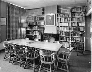
Hector Hodler Library
Distance: Approx. 708 meters
Latitude and longitude: 51.9138,4.4644
The Hector Hodler Library is one of the largest Esperanto libraries, with approximately 30,000 books in addition to periodicals, manuscripts, photos, music, and other collections. It occupies three rooms in the central office of the Universal Esperanto Association (UEA) in Rotterdam, Netherlands. The Swiss Esperanto Society opened the library in Switzerland in 1908.

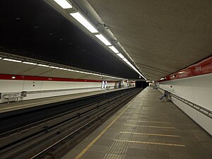
Coolhaven metro station
Metro station in Rotterdam, Netherlands
Distance: Approx. 810 meters
Latitude and longitude: 51.90972222,4.45805556
Coolhaven is an underground subway station in the Dutch city of Rotterdam. It is served by Rotterdam Metro lines A, B, and C. The station, with one island platform, opened on 10 May 1982 as the western terminus of the East-West Line (also formerly called Calandlijn). Coolhaven was the terminus until 1986, when the line was extended to Marconiplein.

Dijkzigt metro station
Metro station in Rotterdam, Netherlands
Distance: Approx. 900 meters
Latitude and longitude: 51.91222222,4.46611111
Dijkzigt is an underground subway station in the city of Rotterdam, and is served by Rotterdam Metro lines A, B, and C. The station is located next to the Erasmus MC (the biggest hospital in the Netherlands) and the Erasmus University. Dijkzigt station was opened on 10 May 1982 as a station of the East-West Line (or Caland line). The station is located underneath the Rochussenstraat and there is interchange with buslines 44 and 46.

Pilgrim Fathers Church
Distance: Approx. 970 meters
Latitude and longitude: 51.909,4.449
The Old or Pilgrim Fathers' Church (Dutch: Oude of Pelgrimvaderskerk Rotterdam-Delfshaven) is a church located in Rotterdam-Delfshaven, in the Netherlands.

Delfshaven metro station
Metro station in Rotterdam, the Netherlands
Distance: Approx. 1010 meters
Latitude and longitude: 51.91,4.44555556
Delfshaven is an underground subway station in the Dutch city of Rotterdam, served by lines A, B, and C of the Rotterdam Metro. The station is part of the two station long extension of the East-West Line (or Caland line), and it opened on 25 April 1986. This extension connected the line's former terminus Coolhaven with the new Marconiplein station.
Nieuwe Westen
Neighborhood of Rotterdam in South Holland, Netherlands
Distance: Approx. 579 meters
Latitude and longitude: 51.91305556,4.44944444
Nieuwe Westen is a pre-war neighbourhood in the west of Rotterdam, located between the Heemraadssingel and the Delfshavense Schie in the Delfshaven district. Nieuwe Westen was built in the early twentieth century. As in the neighbouring Middelland district, Nieuwe Westen is a district of contrasts: completely renovated streets can be found within 100 metres of the stately Heemraadssingel and Mathenesserlaan.
Oude Westen
Neighborhood of Rotterdam in South Holland, Netherlands
Distance: Approx. 849 meters
Latitude and longitude: 51.91805556,4.4675
Oude Westen (Old West) is a neighborhood of Rotterdam, Netherlands adjacent to the city center. The neighborhood was created in the late 19th century when the territory of the district belonged to the then municipality Delfshaven. Delfshaven put few demands on ground operators, which became a neighborhood filled with speculators construction.

Beukelsdijk
Street in Rotterdam, the Netherlands
Distance: Approx. 480 meters
Latitude and longitude: 51.92111111,4.45555556
Beukelsdijk is a street in Rotterdam, connecting Rotterdam and Schiedam. It leads from the crossing with the Henegouwerlaan near the tunnel traverse (where it continues from the Weena), to the Burgemeester Meineszplein in the neighbourhood Middelland, where it continues as the Beukelsweg.

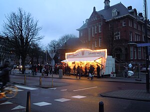
Richard Visser
Dutch pastry chef
Distance: Approx. 97 meters
Latitude and longitude: 51.91744,4.45435
Richard Visser (1968/1969) is a Dutch pastry chef who runs a pastry stand (Dutch: Richard Visser's Gebakkraam) located on the corner of the Heemraadssingel and the Vierambachtsstraat in Rotterdam, which mainly sells oliebollen. In 2011 his oliebollen were named the best in the Netherlands by the Algemeen Dagblad national newspaper in their AD-Oliebollentest; this was his eighth win in nineteen years. He won again in 2013.

The Ocean Cleanup
Dutch nonprofit that alleviates plastic pollution
Distance: Approx. 1001 meters
Latitude and longitude: 51.92083333,4.46833333
The Ocean Cleanup is a nonprofit environmental engineering organization based in the Netherlands that develops technology to extract plastic pollution from the oceans and to capture it in rivers before it can reach the ocean. Their initial focus was on the Pacific Ocean and its garbage patch, and extended to rivers in countries including Indonesia, Guatemala, and the United States. The Ocean Cleanup was founded in 2013 by Boyan Slat, a Dutch inventor who serves as its CEO. It develops both ocean and river based catch systems.

Museum Rotterdam
History museum in Rotterdam, Netherlands
Distance: Approx. 888 meters
Latitude and longitude: 51.90893,4.45745
The Museum Rotterdam, until 2011 called the Historical Museum Rotterdam, is a museum about the history of Rotterdam located at the Coolhaven.
Weather in this IP's area
overcast clouds
5 Celsius
3 Celsius
4 Celsius
6 Celsius
1025 hPa
89 %
1025 hPa
1025 hPa
6000 meters
3.6 m/s
100 degree
100 %
07:49:54
17:02:03

