46.226.131.149 - IP Lookup: Free IP Address Lookup, Postal Code Lookup, IP Location Lookup, IP ASN, Public IP
Country:
 France
Region:
City:
Location:
Time Zone:
Postal Code:
ISP:
ASN:
language:
User-Agent:
Proxy IP:
Blacklist:
IP information under different IP Channel
ip-api
Country
Region
City
ASN
Time Zone
ISP
Blacklist
Proxy
Latitude
Longitude
Postal
Route
db-ip
Country
Region
City
ASN
Time Zone
ISP
Blacklist
Proxy
Latitude
Longitude
Postal
Route
IPinfo
Country
Region
City
ASN
Time Zone
ISP
Blacklist
Proxy
Latitude
Longitude
Postal
Route
IP2Location
46.226.131.149Country
frRegion
pays-de-la-loire
City
le mans
Time Zone
Europe/Paris
ISP
Language
User-Agent
Latitude
Longitude
Postal
ipdata
Country
Region
City
ASN
Time Zone
ISP
Blacklist
Proxy
Latitude
Longitude
Postal
Route
Popular places and events near this IP address

Le Mans
Prefecture and commune in Pays de la Loire, France
Distance: Approx. 865 meters
Latitude and longitude: 48.0077,0.1984
Le Mans (; French: [lə mɑ̃] ) is a city in Northwestern France on the Sarthe River where it meets the Huisne. Traditionally the capital of the province of Maine, it is now the capital of the Sarthe department and the seat of the Roman Catholic diocese of Le Mans. Le Mans is a part of the Pays de la Loire region.

Maine (province)
Place in France
Distance: Approx. 0 meters
Latitude and longitude: 48,0.2
Maine (pronounced [mɛːn] ) is one of the traditional provinces of France. It corresponds to the former County of Maine, whose capital was also the city of Le Mans. The area, now divided into the departments of Sarthe and Mayenne, has about 857,000 inhabitants.
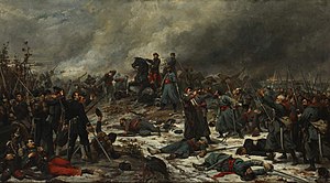
Battle of Le Mans
Battle during the Franco-Prussian War of 1871
Distance: Approx. 521 meters
Latitude and longitude: 48.0042,0.1969
The Battle of Le Mans was a German victory during the Franco-Prussian War that ended French resistance in western France.

Roman Catholic Diocese of Le Mans
Catholic diocese of France
Distance: Approx. 872 meters
Latitude and longitude: 48.00777778,0.19861111
The Diocese of Le Mans (Latin: Dioecesis Cenomanensis; French: Diocèse du Mans) is a Latin Church diocese of the Catholic Church in France. The diocese is now a suffragan of the Archdiocese of Rennes, Dol, and Saint-Malo, but had previously been suffragan to Bourges, Paris, Sens, and Tours (in ascending order). In 2021, in the Diocese of Tulle there was one priest for every 4,705.
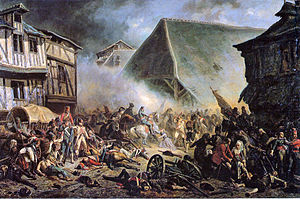
Battle of Le Mans (1793)
Combat in Virée de Galerne
Distance: Approx. 521 meters
Latitude and longitude: 48.0042,0.1969
See Battle of Le Mans for the battle here in 1870 during the Franco-Prussian War. The Battle of Le Mans was a combat in the Virée de Galerne, an operation during the War in the Vendée. It resulted in the rout of the Vendéen forces by Republican troops.

Le Mans station
Railway station in Le Mans, France
Distance: Approx. 746 meters
Latitude and longitude: 47.99555556,0.1925
Le Mans (French: Gare du Mans) is a railway station serving the town Le Mans, Sarthe department, western France. It is situated on the Paris–Brest railway, Le Mans–Angers railway and the non-electrified Tours–Le Mans railway.

Notre-Dame de la Couture, Le Mans
Distance: Approx. 245 meters
Latitude and longitude: 48.0022,0.2
Notre-Dame de la Couture (église de la Couture) is a church in Le Mans. Formerly the abbey church of Saint-Pierre de la Couture Abbey, it is in the centre of the present-day town. It mainly dates to the 12th century - it shows many similarities to Le Mans Cathedral and Angers Cathedral, both built at about the same time.

Abbey of Saint-Pierre de la Couture
Distance: Approx. 200 meters
Latitude and longitude: 48.0018,0.2
Abbey of Saint-Pierre de la Couture (French: Abbaye Saint-Pierre de la Couture) was a Benedictine monastery in Le Mans. All that survives of it is the abbey church and some of the abbey buildings; the latter date to a rebuild between 1760 and 1775 and are now used to house the prefecture for Sarthe. Dating to the 11th century, the monastery was considered one of the most powerful in western France before the French Revolution.

Canton of Le Mans-3
Distance: Approx. 0 meters
Latitude and longitude: 48,0.2
The canton of Le Mans-3 is an administrative division of the Sarthe department, northwestern France. It was created at the French canton reorganisation which came into effect in March 2015. Its seat is in Le Mans.

Le Mans Métropole
Communauté urbaine in Pays de la Loire, France
Distance: Approx. 0 meters
Latitude and longitude: 48,0.2
The Communauté urbaine Le Mans Métropole is the communauté urbaine, an intercommunal structure, centred on the city of Le Mans. It is located in the Sarthe department, in the Pays de la Loire region, northwestern France. It was created in November 1971.

Notre Dame de Sainte Croix, Le Mans
Catholic church located in Le Mans, France
Distance: Approx. 852 meters
Latitude and longitude: 48.0036,0.2101
Notre Dame de Sainte Croix is a Catholic church located in the city of Le Mans, France. The church gives its name to the neighborhood itself. It was the first site of the Congregation of Holy Cross.

Hôtel de Ville, Le Mans
Town hall in Le Mans, France
Distance: Approx. 848 meters
Latitude and longitude: 48.0074,0.1973
The Hôtel de Ville (French pronunciation: [otɛl də vil], City Hall) is a municipal building in Le Mans, Sarthe, northwest France, standing on the Place Saint-Pierre. It was designated a monument historique by the French government in 1930.
Weather in this IP's area
light intensity drizzle
5 Celsius
5 Celsius
5 Celsius
5 Celsius
1039 hPa
100 %
1039 hPa
1029 hPa
3400 meters
1.03 m/s
60 degree
100 %