Country:
 France
Region:
City:
Latitude and Longitude:
Time Zone:
Postal Code:
IP information under different IP Channel
ip-api
Country
Region
City
ASN
Time Zone
ISP
Blacklist
Proxy
Latitude
Longitude
Postal
Route
IPinfo
Country
Region
City
ASN
Time Zone
ISP
Blacklist
Proxy
Latitude
Longitude
Postal
Route
MaxMind
Country
Region
City
ASN
Time Zone
ISP
Blacklist
Proxy
Latitude
Longitude
Postal
Route
Luminati
Country
FRRegion
ara
City
vienne
ASN
Time Zone
Europe/Paris
ISP
Alsatis SAS
Latitude
Longitude
Postal
db-ip
Country
Region
City
ASN
Time Zone
ISP
Blacklist
Proxy
Latitude
Longitude
Postal
Route
ipdata
Country
Region
City
ASN
Time Zone
ISP
Blacklist
Proxy
Latitude
Longitude
Postal
Route
Popular places and events near this IP address

Vienne, Isère
Subprefecture in France
Distance: Approx. 604 meters
Latitude and longitude: 45.5242,4.8781
Vienne (French: [vjɛn] ; Arpitan: Vièna) is a town in southeastern France, located 35 kilometres (22 mi) south of Lyon, at the confluence of the Gère and the Rhône. It is the fourth-largest commune in the Isère department, of which it is a subprefecture alongside La Tour-du-Pin. Vienne was a major centre of the Roman Empire under the Latin name Vienna.
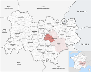
Arrondissement of Vienne
Arrondissement in Auvergne-Rhône-Alpes, France
Distance: Approx. 420 meters
Latitude and longitude: 45.52277778,4.87361111
The arrondissement of Vienne is an arrondissement of France in the Isère department in the Auvergne-Rhône-Alpes region. It has 113 communes. Its population is 212,383 (2016), and its area is 1,489.7 km2 (575.2 sq mi).
Roman Catholic Archdiocese of Vienne
Former French archdiocese
Distance: Approx. 671 meters
Latitude and longitude: 45.52,4.87
The Archbishopric of Vienne, named after its episcopal seat in Vienne in the Isère département of southern France, was a metropolitan Roman Catholic archdiocese. It is now part of the Archdiocese of Lyon.

La Pyramide
Historic site in Vienne, France
Distance: Approx. 1094 meters
Latitude and longitude: 45.5165417,4.86700556
Restaurant De La Pyramide, popularly known as La Pyramide, was a Michelin Guide 3-star restaurant located in Vienne, Isère, France. It was widely regarded as the greatest restaurant in France while its owner Fernand Point (1897–1955) was alive.
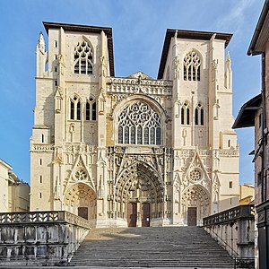
Vienne Cathedral
Church in Isère, France
Distance: Approx. 269 meters
Latitude and longitude: 45.52416667,4.87305556
Vienne Cathedral (French: Cathédrale Saint-Maurice de Vienne) is a medieval Roman Catholic church in the city of Vienne, France. Dedicated to Saint Maurice, it was the episcopal see of the primate of the ancient Septem Provinciae and of the Archdiocese of Vienne until its abolition confirmed by the Concordat of 1801. It today serves as co-cathedral of the Diocese of Grenoble-Vienne.

Sainte-Colombe, Rhône
Commune in Auvergne-Rhône-Alpes, France
Distance: Approx. 258 meters
Latitude and longitude: 45.5261,4.8675
Sainte-Colombe (French pronunciation: [sɛ̃t kɔlɔ̃b] ; Arpitan: Sente-Colomba), sometimes referred to as Sainte-Colombe-lès-Vienne, is a commune in the Rhône department in eastern France. Occupied since Roman times, it is across the Rhône river from Vienne.

Saint-Romain-en-Gal
Commune in Auvergne-Rhône-Alpes, France
Distance: Approx. 1038 meters
Latitude and longitude: 45.533,4.862
Saint-Romain-en-Gal (French pronunciation: [sɛ̃ ʁɔmɛ̃ ɑ̃ ɡal]; Arpitan: Sant-Reman-en-Gâl) is a commune in the Rhône department in eastern France. It is located 35 kilometres (22 mi) south of Lyon, on the west bank of the river Rhône. Vienne, Isère is on the opposite bank of the river and the two settlements are linked by a footbridge and a road bridge.
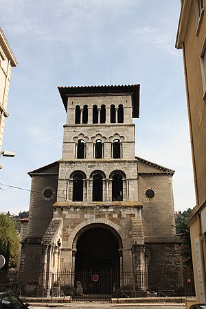
Saint Peter's church, Vienne (Isère)
Church located in Vienne, France
Distance: Approx. 334 meters
Latitude and longitude: 45.523,4.8707
Saint Peter's church (Saint-Pierre-le-Bas) in Vienne is one of the oldest surviving churches in France, situated in the Rhône-Alpes region. The church was added to the 1862 version of the list of France's Monuments historiques, created in 1819.
Canton of Vienne-1
Distance: Approx. 844 meters
Latitude and longitude: 45.53,4.88
The canton of Vienne-1 is an administrative division of the Isère department, eastern France. It was created at the French canton reorganisation which came into effect in March 2015. Its seat is in Vienne.
Canton of Vienne-2
Distance: Approx. 671 meters
Latitude and longitude: 45.52,4.87
The canton of Vienne-2 is an administrative division of the Isère department, eastern France. It was created at the French canton reorganisation which came into effect in March 2015. Its seat is in Vienne.
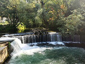
Gère
River in Auvergne-Rhône-Alpes, France
Distance: Approx. 293 meters
Latitude and longitude: 45.5279,4.8734
The Gère (French pronunciation: [ʒɛʁ]) is a 34.5-kilometre-long (21.4 mi) tributary of the Rhône in the Isère department of Auvergne-Rhône-Alpes (France). Its source is in a pond of the Grand Tuilière in the eastern part of the Bonnevaux forest. It flows into the Rhone at Vienne.

Temple of Augustus and Livia
Roman temple located in Isère, France
Distance: Approx. 275 meters
Latitude and longitude: 45.52548,4.87425
The Temple of Augustus and Livia is a Roman peripteral sine postico hexastyle Corinthian temple built at the beginning of the 1st century, which was in the center of the ancient city of Vienne, also corresponding to the center of the modern city, in the French department of Isère and the region of Auvergne-Rhône-Alpes.
Weather in this IP's area
overcast clouds
14 Celsius
14 Celsius
13 Celsius
15 Celsius
1012 hPa
90 %
1012 hPa
994 hPa
10000 meters
1.45 m/s
2.58 m/s
168 degree
88 %
08:00:57
18:49:56