Country:
 Germany
Region:
City:
Latitude and Longitude:
Time Zone:
Postal Code:
IP information under different IP Channel
ip-api
Country
Region
City
ASN
Time Zone
ISP
Blacklist
Proxy
Latitude
Longitude
Postal
Route
IPinfo
Country
Region
City
ASN
Time Zone
ISP
Blacklist
Proxy
Latitude
Longitude
Postal
Route
MaxMind
Country
Region
City
ASN
Time Zone
ISP
Blacklist
Proxy
Latitude
Longitude
Postal
Route
Luminati
Country
DERegion
hh
City
hamburg
ASN
Time Zone
Europe/Berlin
ISP
wilhelm.tel GmbH
Latitude
Longitude
Postal
db-ip
Country
Region
City
ASN
Time Zone
ISP
Blacklist
Proxy
Latitude
Longitude
Postal
Route
ipdata
Country
Region
City
ASN
Time Zone
ISP
Blacklist
Proxy
Latitude
Longitude
Postal
Route
Popular places and events near this IP address
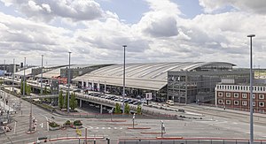
Hamburg Airport
Airport in Hamburg, Germany
Distance: Approx. 2636 meters
Latitude and longitude: 53.63027778,9.99111111
Hamburg Airport (German: Flughafen Hamburg „Helmut Schmidt”) (IATA: HAM, ICAO: EDDH), is a major international airport in Hamburg, the second-largest city in Germany. Since November 2016 the airport has been named after the former German chancellor Helmut Schmidt. It is located 8.5 km (5.3 mi) north of the city centre in the Fuhlsbüttel quarter and serves as a hub for Eurowings and focus city for Condor.

Niendorf, Hamburg
Quarter of Hamburg in Germany
Distance: Approx. 2933 meters
Latitude and longitude: 53.61777778,9.95027778
Niendorf () is one of 105 quarters of Hamburg, Germany in the Eimsbüttel borough. In 2020 the population was 40,906.

Langenhorn, Hamburg
Quarter of Hamburg in Germany
Distance: Approx. 2846 meters
Latitude and longitude: 53.65,10
is a quarter in the borough Hamburg-Nord of Hamburg, Germany. In 2020 the population was 46,272.

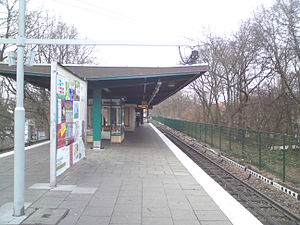
Niendorf Nord station
Railway station in Hamburg, Germany
Distance: Approx. 644 meters
Latitude and longitude: 53.64055556,9.95
Niendorf Nord is the western terminus station for the rapid transit trains of Hamburg U-Bahn line U2. The station is located in the Niendorf quarter of Hamburg, Germany.

Old Niendorf Cemetery
Historic cemetery in Hamburg Germany
Distance: Approx. 3122 meters
Latitude and longitude: 53.61611111,9.94972222
The Lutheran Old Niendorf Cemetery (German: Alter Niendorfer Friedhof) is a church-operated historic burial ground in Hamburg, Germany. The cemetery is owned by the Evangelical Lutheran parish church of Niendorf, Hamburg.
Fuhlsbüttel Nord station
Railway station in Hamburg, Germany
Distance: Approx. 3886 meters
Latitude and longitude: 53.6397,10.0167
Fuhlsbüttel Nord (Fuhlsbüttel North) is a station on the Hamburg U-Bahn line U1. It was opened in July 1921 and is located in Hamburg, Germany, on the boundaries of the quarters of Fuhlsbüttel and Langenhorn. Both are part of the borough of Hamburg-Nord.

Groß Borstel
Quarter of Hamburg in Germany
Distance: Approx. 3711 meters
Latitude and longitude: 53.61366,9.98259
Groß Borstel () (Great Borstel) is a quarter of Hamburg, Germany, in the borough of Hamburg-Nord. It is located north of the Eppendorf quarter and south of Hamburg Airport. Near Groß Borstel, the neighbourhood of Klein Borstel, which is not an official quarter, can be found.

Schnelsen
Quarter of Hamburg in Germany
Distance: Approx. 2974 meters
Latitude and longitude: 53.63333333,9.91666667
Schnelsen () is a quarter of Hamburg, Germany, in the borough of Eimsbüttel. In 2020 it had a population of over 30,100 people and borders the state of Schleswig-Holstein.

Niendorf Markt station
Railway station in Hamburg, Germany
Distance: Approx. 2708 meters
Latitude and longitude: 53.6197,9.9515
Niendorf Markt is a metro station in Niendorf on the Hamburg U-Bahn line U2.

Joachim-Mähl-Straße station
Metro station in Hamburg, Germany
Distance: Approx. 1803 meters
Latitude and longitude: 53.6282,9.9503
Joachim-Mähl-Straße is a metro station in Niendorf, Hamburg on the Hamburg U-Bahn line U2.

Schippelsweg station
Railway station in Hamburg, Germany
Distance: Approx. 1008 meters
Latitude and longitude: 53.6353,9.9525
Schippelsweg is a metro station in Niendorf, Hamburg, on the Hamburg U-Bahn line U2.

Edmund-Plambeck-Stadion
Sports venue in Norderstedt, Germany
Distance: Approx. 3922 meters
Latitude and longitude: 53.6771,9.9771
The Edmund-Plambeck-Stadion (formerly known as the Stadion Ochsenzoller Straße) is a multi-use stadium in Norderstedt, Schleswig-Holstein, Germany.
Weather in this IP's area
moderate rain
11 Celsius
10 Celsius
10 Celsius
11 Celsius
1013 hPa
94 %
1013 hPa
1011 hPa
10000 meters
2.57 m/s
70 degree
07:55:13
18:14:37