46.214.222.184 - IP Lookup: Free IP Address Lookup, Postal Code Lookup, IP Location Lookup, IP ASN, Public IP
Country:
Region:
City:
Location:
Time Zone:
Postal Code:
ISP:
ASN:
language:
User-Agent:
Proxy IP:
Blacklist:
IP information under different IP Channel
ip-api
Country
Region
City
ASN
Time Zone
ISP
Blacklist
Proxy
Latitude
Longitude
Postal
Route
db-ip
Country
Region
City
ASN
Time Zone
ISP
Blacklist
Proxy
Latitude
Longitude
Postal
Route
IPinfo
Country
Region
City
ASN
Time Zone
ISP
Blacklist
Proxy
Latitude
Longitude
Postal
Route
IP2Location
46.214.222.184Country
Region
giurgiu
City
giurgiu
Time Zone
Europe/Bucharest
ISP
Language
User-Agent
Latitude
Longitude
Postal
ipdata
Country
Region
City
ASN
Time Zone
ISP
Blacklist
Proxy
Latitude
Longitude
Postal
Route
Popular places and events near this IP address
Giurgiu
City in southern Romania
Distance: Approx. 2035 meters
Latitude and longitude: 43.90083333,25.97388889
Giurgiu (Romanian pronunciation: [ˈdʒjurdʒju] ; Bulgarian: Гюргево, romanized: Gyurgevo) is a city in southern Romania. The seat of Giurgiu County, it lies in the historical region of Muntenia. It is situated amongst mud-flats and marshes on the left bank of the Danube facing the Bulgarian city of Ruse on the opposite bank.
Danube Bridge
Bridge connecting Romania and Bulgaria
Distance: Approx. 3122 meters
Latitude and longitude: 43.89053056,26.00429167
The Danube Bridge (also known as the Friendship Bridge; Bulgarian: Мост на дружбата, Most na druzhbata or, more commonly, Дунав мост, Dunav most; Romanian: Podul Prieteniei or Podul de la Giurgiu) is a steel truss bridge over the Danube River connecting the Bulgarian bank to the south with the Romanian bank to the north and the cities of Ruse and Giurgiu respectively. It is one of only two bridges connecting Romania and Bulgaria, the other one being the New Europe Bridge between the cities of Vidin and Calafat.
Lokomotiv Stadium (Ruse)
Distance: Approx. 2808 meters
Latitude and longitude: 43.86069444,25.98222222
Stadium Lokomotiv is a multi-purpose stadium in Rousse, Bulgaria. It is currently used mostly for football matches and is the home ground of FC Lokomotiv Ruse. The stadium holds 12,000 people.
University of Ruse
Public university in Ruse, Bulgaria
Distance: Approx. 3225 meters
Latitude and longitude: 43.85444444,25.97027778
"Angel Kanchev" University of Ruse (Bulgarian: Русенски университет „Ангел Кънчев“) is a public university in the city of Ruse, Bulgaria. The university was formed on 21 July 1995 by the dissolution of Higher Institute of Mechanical Engineering, Mechanisation and Electrification of Agriculture (Bulgarian: Висш институт по машиностроене, механизация и електрификация на селското стопанство) which was commonly known as (Bulgarian: ВИММЕСС) with establishment date 12 November 1945. This was the first national higher technical school outside the Bulgarian capital.

Pantheon of National Revival Heroes
Distance: Approx. 3675 meters
Latitude and longitude: 43.85055556,25.96091667
The Pantheon of National Revival Heroes (Bulgarian: Пантеон на възрожденците) is a Bulgarian national monument and an ossuary, located in the city of Rousse. The remains of 39 famous Bulgarians are interred there, including: Lyuben Karavelov, Zahari Stoyanov, Stefan Karadzha, Panayot Hitov, Tonka Obretenova, Nikola Obretenov, Panayot Volov, Angel Kanchev, and others; 453 other participants in Botev's detachment, the Chervena Voda detachment, in the April uprising, and other revolutionaries have been honored by inscription of their names in the interior. An eternal fire burns in the middle under the gold-plated dome.

Kaliopa House
Bulgarian museum
Distance: Approx. 3584 meters
Latitude and longitude: 43.85277778,25.9525
The Kaliopa House (Bulgarian: Къщата на Калиопа), a popular name for the Bulgarian "Urban lifestyle of Rousse" museum (Bulgarian: Къща музей „Градски бит на Русе“), was built in 1864. According to a legend, the house was bestowed upon the beautiful Kaliopa (born Maria Kalish), the wife of the Prussian consul Kalish, by the governor of the Danubian Vilayet, Midhat Pasha, who was in love with her. The facade's design resembles the style of houses in Plovdiv.

National Transport Museum, Bulgaria
Railway museum in Ruse, Bulgaria
Distance: Approx. 2532 meters
Latitude and longitude: 43.86066667,25.96361111
The National Transport Museum (Bulgarian: Национален музей на транспорта; Natsionalen Muzey na Transporta) in Ruse, Bulgaria, is situated on the bank of the Danube, in the country's first railway station, built in 1866.
Dormition of the Theotokos Cathedral, Giurgiu
Orthodox Christian Cathedral in Giurgiu County, Romania
Distance: Approx. 947 meters
Latitude and longitude: 43.8918,25.9664
The Dormition of the Theotokos Cathedral, Giurgiu (Romanian: Catedrala Adormirea Maicii Domnului din Giurgiu), located at 12 București Street, Giurgiu, Romania, is the seat of the Romanian Orthodox Bishop of Giurgiu.

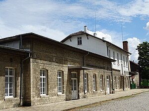
Giurgiu railway station
Railway station in Giurgiu, Romania
Distance: Approx. 1429 meters
Latitude and longitude: 43.89555556,25.96138889
The Giurgiu railway station is a train station in the town of Giurgiu, Romania. The station was opened in 1869 as part of the Bucharest-Giurgiu railway. Today, the station is only served by commuter (personal) trains to Bucharest, Grădiștea and Videle.

Giurgiu Clocktower
Distance: Approx. 789 meters
Latitude and longitude: 43.89027778,25.965
The Giurgiu Clocktower (Romanian: Turnul Ceasornicului; Turkish: Yergöğü Saat Külesi) is a Historic Monument located in the City of Giurgiu, Romania. It has been designated by the Romanian Ministry of Culture and National Patrimony as monument of national importance. The city of Girgiu is located on the Danube river near the Bulgarian border.

Giurgiu shipyard
Distance: Approx. 807 meters
Latitude and longitude: 43.87705556,25.97180556
The Giurgiu shipyard (Romanian: Șantierul naval Giurgiu), formally Shipyard ATG Giurgiu, is a shipyard located on the Danube in Giurgiu, a city located in the Muntenia region of Romania. Ship repair began in Giurgiu in 1897. Starting in 1910, the yard’s activity expanded and diversified.

Ion Maiorescu National College
High school in Romania
Distance: Approx. 1013 meters
Latitude and longitude: 43.8924,25.9664
Ion Maiorescu National College (Romanian: Colegiul Național Ion Maiorescu) is a high school located at 8 Nicolae Droc Barcian Street, Giurgiu, Romania. The Giurgiu City Council decided to open a gymnasium in 1868, and work soon began on a building. Ready in little over a year, the school opened in November 1869.
Weather in this IP's area
broken clouds
-1 Celsius
-3 Celsius
-1 Celsius
-1 Celsius
1030 hPa
69 %
1030 hPa
1021 hPa
10000 meters
1.39 m/s
1.4 m/s
270 degree
65 %


