Country:
Region:
City:
Latitude and Longitude:
Time Zone:
Postal Code:
IP information under different IP Channel
ip-api
Country
Region
City
ASN
Time Zone
ISP
Blacklist
Proxy
Latitude
Longitude
Postal
Route
Luminati
Country
Region
ore
City
orenburg
ASN
Time Zone
Asia/Yekaterinburg
ISP
JSC Ufanet
Latitude
Longitude
Postal
IPinfo
Country
Region
City
ASN
Time Zone
ISP
Blacklist
Proxy
Latitude
Longitude
Postal
Route
db-ip
Country
Region
City
ASN
Time Zone
ISP
Blacklist
Proxy
Latitude
Longitude
Postal
Route
ipdata
Country
Region
City
ASN
Time Zone
ISP
Blacklist
Proxy
Latitude
Longitude
Postal
Route
Popular places and events near this IP address

Orenburg
Administrative centre of Orenburg Oblast, Russia
Distance: Approx. 728 meters
Latitude and longitude: 51.78333333,55.1
Orenburg (Russian: Оренбу́рг, pronounced [ɐrʲɪnˈburk]; Kazakh: Орынбор), formerly known as Chkalov (1938–1957), is the administrative center of Orenburg Oblast, Russia and former capital of the Kazak ASSR. It lies on Eastern Europe, on the banks of the Ural River, where it forms the boundary between Europe and Asia, and is 1,478 kilometers (918 mi) southeast of Moscow. Orenburg is close to the border with Kazakhstan.

Sakmara (river)
River in Bashkortostan and Orenburg Oblast, Russia
Distance: Approx. 5332 meters
Latitude and longitude: 51.7722,55.0264
The Sakmara (Russian: Сакмара; Bashkir: Һаҡмар, Haqmar) is a river in Russia that drains the southern tip of the Ural Mountains south into the river Ural. It is 798 kilometres (496 mi) long, and has a drainage basin of 30,200 square kilometres (11,700 sq mi). It is a right tributary of the Ural, which it meets in Orenburg.

Orenburg Governorate
1744–1928 unit of Russia
Distance: Approx. 2574 meters
Latitude and longitude: 51.7667,55.1
Orenburg Governorate (Russian: Оренбургская губерния, romanized: Orenburgskaya guberniya) was an administrative-territorial unit (Governorate) of the Russian Empire. Its capital in 1797–1802 and 1865–1928 was Orenburg, and Ufa in 1802–1865. The governorate was created in 1744 from the lands annexed from Siberian and Astrakhan Governorates.
Orenburg State Institute of Management
Public higher education institute in Orenburg, Russia
Distance: Approx. 5153 meters
Latitude and longitude: 51.8342,55.1196
Orenburg State Institute of Management (OSIM) is a Russian international state university which is training specialists in such spheres as: Economics; Management; Management of Organization; Public and Municipal Management; Information Management; Information Technologies and Security; Economics and Management of Enterprise (Municipal Services); Accounting, Analysis and Audit; Business Informatics; Applied Information Science; Innovation; Tourism.

Orenburg State University
Public university in Orenburg, Russia
Distance: Approx. 1471 meters
Latitude and longitude: 51.778,55.108
Orenburg State University (Russian: Оренбургский государственный университет, Orenburgskiy gosudárstvennyy universitét), previously known as Orenburg Polytechnic Institute (Russian: Оренбургский Политехнический Институт, Russian: ОГУ, OGU), is a university in Orenburg, Orenburg Oblast, Russia.

Orenburg Caravanserai
Historic site in Orenburg, Orenburg Oblast
Distance: Approx. 2077 meters
Latitude and longitude: 51.7714,55.0934
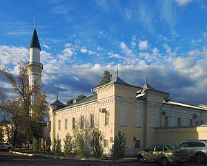
The Orenburg Caravanserai (Bashkir: Каруанһарай) is a mosque, historical and architectural complex in Orenburg. It is a cultural monument of the Bashkir people. The caravanserai was built in 1837–1846 with donations as a place for the Office of the Bashkir-mesheryak army commander, hotels for Bashkirs who came to Orenburg for services and a workshop and school.

Gazovik Stadium (Orenburg)
Multi-purpose stadium in Orenburg, Russia
Distance: Approx. 8470 meters
Latitude and longitude: 51.78505,55.22116
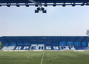
Gazovik Stadium is a multi-purpose stadium in Orenburg, Russia. It is currently used mostly for football matches and is the home stadium of FC Orenburg. The stadium holds 10,046 people, all seated.

House of the Soviets (Orenburg)
Building in Orenburg, Russia
Distance: Approx. 2522 meters
Latitude and longitude: 51.7672,55.0958
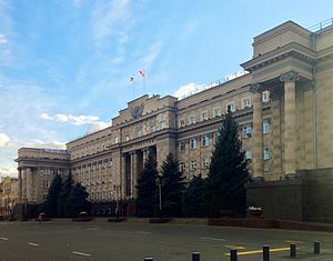
The House of the Soviets (Russian: Дом Советов) is the headquarters of the government of Orenburg Oblast and the governor of the oblast.

Orenburg Regional Museum of Fine Arts
Distance: Approx. 3290 meters
Latitude and longitude: 51.7603,55.1014
Orenburg Regional Museum of Fine Arts (Russian: Оренбургский областной музей изобразительных искусств) is an art museum located in Orenburg, Russia. It was opened to the public in 1961. The gallery houses a collection of Soviet, Russian, and Western European art, and was initially predicated on a collection of Lukian Popov works.

Orenburg State Pedagogical University
State university in Orenburg, Russia
Distance: Approx. 3360 meters
Latitude and longitude: 51.75972222,55.1025
Orenburg State Pedagogical University (OSPU; Russian: Оренбургский государственный педагогический университет; ОГПУ, Orenburgskiy gosudarstvennyy pedagogicheskiy universitet; OGPU) is a state university in Volga Federal District of Russia located in the city of Orenburg, the administrative centre of Orenburg Oblast.

Museum of Orenburg History
A history museum in Orenburg, Russia
Distance: Approx. 3888 meters
Latitude and longitude: 51.755417,55.108325
The Museum of Orenburg History is a municipal and local history museum in Orenburg. It is located in a historical building from the mid-19th century, which is a monument of federal significance. It was opened in 1983 as a department of the pre-Soviet period of Russian history in the Orenburg Governor's Local Lore and History Museum.
Weather in this IP's area
overcast clouds
1 Celsius
-4 Celsius
1 Celsius
1 Celsius
1014 hPa
98 %
1014 hPa
1001 hPa
2051 meters
6.28 m/s
12.54 m/s
269 degree
100 %
08:30:14
17:36:57