46.18.175.2 - IP Lookup: Free IP Address Lookup, Postal Code Lookup, IP Location Lookup, IP ASN, Public IP
Country:
Region:
City:
Location:
Time Zone:
Postal Code:
IP information under different IP Channel
ip-api
Country
Region
City
ASN
Time Zone
ISP
Blacklist
Proxy
Latitude
Longitude
Postal
Route
Luminati
Country
ASN
Time Zone
Europe/London
ISP
IX Reach Ltd
Latitude
Longitude
Postal
IPinfo
Country
Region
City
ASN
Time Zone
ISP
Blacklist
Proxy
Latitude
Longitude
Postal
Route
IP2Location
46.18.175.2Country
Region
england
City
high wycombe
Time Zone
Europe/London
ISP
Language
User-Agent
Latitude
Longitude
Postal
db-ip
Country
Region
City
ASN
Time Zone
ISP
Blacklist
Proxy
Latitude
Longitude
Postal
Route
ipdata
Country
Region
City
ASN
Time Zone
ISP
Blacklist
Proxy
Latitude
Longitude
Postal
Route
Popular places and events near this IP address

High Wycombe
Town in Buckinghamshire, England
Distance: Approx. 88 meters
Latitude and longitude: 51.628661,-0.748238
High Wycombe, often referred to as Wycombe ( WIK-əm), is a market town in Buckinghamshire, England. Lying in the valley of the River Wye surrounded by the Chiltern Hills, it is 29 miles (47 km) west-northwest of Charing Cross in London, 13 miles (21 km) south-southeast of Aylesbury, 23 miles (37 km) southeast of Oxford, 15 miles (24 km) northeast of Reading and 8 miles (13 km) north of Maidenhead. According to the 2021 United Kingdom census, High Wycombe's built up area has a population of 127,856, making it the largest town in the ceremonial county of Buckinghamshire.

Wycombe Abbey
Private girls' school in High Wycombe, Buckinghamshire, England
Distance: Approx. 371 meters
Latitude and longitude: 51.62611111,-0.75166667
Wycombe Abbey is a private girls' boarding and day school in High Wycombe, Buckinghamshire, England. The school was founded in 1896 by Dame Frances Dove (1847–1942), who was previously headmistress of St Leonards School in Scotland. Its present capacity is approximately 650 girls, aged 11 to 18.

Buckinghamshire New University
Multi-campus public university in the United Kingdom
Distance: Approx. 223 meters
Latitude and longitude: 51.628,-0.752
Buckinghamshire New University (BNU) is a public university in Buckinghamshire, England, with campuses in High Wycombe, Aylesbury, Uxbridge and Great Missenden. The institution dates from 1891, when it was founded as the School of Science and Art, and has since then has variously been known as Wycombe Technical Institute, High Wycombe College of Technology and Art and the Buckinghamshire College of Higher Education. It was a university college from 1999 until 2007, when its application for university status was accepted.
High Wycombe railway station
Railway station in Buckinghamshire, England
Distance: Approx. 314 meters
Latitude and longitude: 51.63,-0.745
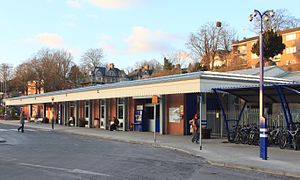
High Wycombe railway station is a railway station in the market town of High Wycombe in Buckinghamshire, England. The station is on the Chiltern Main Line between Beaconsfield and Saunderton stations. It is served by Chiltern Railways.

Wycombe Swan
Theatre in England
Distance: Approx. 126 meters
Latitude and longitude: 51.6282,-0.7504
Wycombe Swan is a theatre in High Wycombe, Buckinghamshire, England. The theatre was opened in November 1992 by Wycombe District Council and is now operated by Trafalgar Entertainment. The Wycombe Swan complex consists of the main theatre, the Wycombe Swan Town Hall, and the Oak Room, all of which can be hired for events.

Wycombe Museum
Local museum in Buckinghamshire, England
Distance: Approx. 259 meters
Latitude and longitude: 51.6313,-0.7481
Wycombe Museum (aka Wycombe Local History and Chair Museum) is a free local museum located in the town of High Wycombe, Buckinghamshire, England. It is run by Wycombe Heritage and Arts Trust, as of 1 December 2016. It was previously run by Wycombe District Council.

Eden Shopping Centre
Shopping mall in Buckinghamshire, England
Distance: Approx. 312 meters
Latitude and longitude: 51.6275,-0.753
The Eden Shopping Centre, commonly known as Eden, is a shopping and entertainment complex in High Wycombe, Buckinghamshire in the south east of England. With a floor area of 850,000 square feet (79,000 m2), it is the 37th largest shopping centre in the United Kingdom and the largest in the surrounding area. The centre has 107 shops, a bowling alley, a cinema, a library (which opened on 3 June 2008), 48 residential flats and parking for 1,600 cars on site with other car parks available nearby.

Magic Roundabout (High Wycombe)
Ring junction in High Wycombe, Buckinghamshire, England,
Distance: Approx. 255 meters
Latitude and longitude: 51.62694444,-0.75055556
The Magic Roundabout (officially named Abbey Way Gyratory) in High Wycombe, Buckinghamshire, England, is similar to the complex roundabouts in Hemel Hempstead and other places. It is located on the junction of the A40 and A404 roads.

High Wycombe Guildhall
Municipal building in High Wycombe, Buckinghamshire, England
Distance: Approx. 149 meters
Latitude and longitude: 51.62932,-0.75142
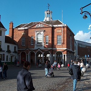
The High Wycombe Guildhall is a public building located on the High Street of High Wycombe in Buckinghamshire, England. It is a Grade I listed building. It was designed by Henry Keene and completed in 1757.

Royal Military College, High Wycombe
British military training facility
Distance: Approx. 31 meters
Latitude and longitude: 51.629,-0.74972
The Royal Military College, High Wycombe was a military training facility for British Army officers in High Wycombe in Buckinghamshire.

High Wycombe Town Hall
Municipal building in High Wycombe, Buckinghamshire, England
Distance: Approx. 145 meters
Latitude and longitude: 51.6278,-0.7494
High Wycombe Town Hall is a public building located on Queen Victoria Road in High Wycombe, Buckinghamshire, England. The building, which is used as an events venue, is a Grade II listed building.

Municipal Offices, High Wycombe
Municipal building in High Wycombe, Buckinghamshire, England
Distance: Approx. 191 meters
Latitude and longitude: 51.6274,-0.7489
The Municipal Offices are located on Queen Victoria Road in High Wycombe, Buckinghamshire, England. The structure is used as the High Wycombe local area office of Buckinghamshire Council.
Weather in this IP's area
overcast clouds
5 Celsius
5 Celsius
5 Celsius
6 Celsius
1010 hPa
86 %
1010 hPa
1001 hPa
10000 meters
0.45 m/s
1.34 m/s
277 degree
96 %
