46.172.84.36 - IP Lookup: Free IP Address Lookup, Postal Code Lookup, IP Location Lookup, IP ASN, Public IP
Country:
Region:
City:
Location:
Time Zone:
Postal Code:
IP information under different IP Channel
ip-api
Country
Region
City
ASN
Time Zone
ISP
Blacklist
Proxy
Latitude
Longitude
Postal
Route
Luminati
Country
Region
63
City
kharkiv
ASN
Time Zone
Europe/Kyiv
ISP
It-starcom LLC
Latitude
Longitude
Postal
IPinfo
Country
Region
City
ASN
Time Zone
ISP
Blacklist
Proxy
Latitude
Longitude
Postal
Route
IP2Location
46.172.84.36Country
Region
kharkivska oblast
City
korotych
Time Zone
Europe/Kiev
ISP
Language
User-Agent
Latitude
Longitude
Postal
db-ip
Country
Region
City
ASN
Time Zone
ISP
Blacklist
Proxy
Latitude
Longitude
Postal
Route
ipdata
Country
Region
City
ASN
Time Zone
ISP
Blacklist
Proxy
Latitude
Longitude
Postal
Route
Popular places and events near this IP address
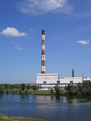
Kharkiv TEC-5
Combined heat and power plant in Kharkiv Oblast, Ukraine
Distance: Approx. 5171 meters
Latitude and longitude: 49.97138889,36.10055556
Kharkiv TEC-5 (Ukrainian: Харківська ТЕЦ-5) is a combined heat and power plant (CHP) near Podvirky village in Kharkiv Raion of Kharkiv Oblast, Ukraine. It is the second largest CHP plant in Ukraine. It has a capacity of 540 MW of electric power and up to 1,650 MW of heat power.

Liubotyn
City in Kharkiv Oblast, Ukraine
Distance: Approx. 7969 meters
Latitude and longitude: 49.94833333,35.92944444
Liubotyn or Lyubotyn (Ukrainian: Люботин, pronounced [lʲʊboˈtɪn]; Russian: Люботин, romanized: Lyubotin) is a city in Kharkiv Raion, Kharkiv Oblast, eastern Ukraine. It hosts the administration of Liubotyn urban hromada, one of the hromadas of Ukraine. Population: 20,001 (2022 estimate).
Pivdenne, Kharkiv Oblast
City in Kharkiv Oblast, Ukraine
Distance: Approx. 7168 meters
Latitude and longitude: 49.88333333,36.06666667
Pivdenne (Ukrainian: Південне; Russian: Пивденное) is a small city in Kharkiv Raion, Kharkiv Oblast, Ukraine. It hosts the administration of Pivdenne urban hromada, one of the hromadas of Ukraine. Population: 7,319 (2022 estimate).

Nova Bavaria Stadium
Distance: Approx. 9998 meters
Latitude and longitude: 49.95,36.18
Nova Bavaria is a small football stadium in the city of Kharkiv, Ukraine. Until 2020, it was known as Helios Arena.
Peresichne
Rural locality in Kharkiv Oblast, Ukraine
Distance: Approx. 9498 meters
Latitude and longitude: 50.02194444,35.98166667
Peresichne (Ukrainian: Пересічне, Russian: Пересечное) is a rural settlement in Kharkiv Raion of Kharkiv Oblast in Ukraine. It is located on the left bank of the Udy, in the drainage basin of the Don. Peresichne belongs to Solonytsivka settlement hromada, one of the hromadas of Ukraine.

Solonytsivka
Rural locality in Kharkiv Oblast, Ukraine
Distance: Approx. 4860 meters
Latitude and longitude: 49.98694444,36.06194444
Solonytsivka (Ukrainian: Солоницівка, Russian: Солоницевка) is a rural settlement in Kharkiv Raion of Kharkiv Oblast in Ukraine. It is located on the banks of the Udy, in the drainage basin of the Don. Solonytsivka hosts the administration of Solonytsivka settlement hromada, one of the hromadas of Ukraine.
Berezivka, Kharkiv Raion, Kharkiv Oblast
Rural locality in Kharkiv Oblast, Ukraine
Distance: Approx. 4968 meters
Latitude and longitude: 49.90444444,36.06777778
Berezivka (Ukrainian: Березівка, Russian: Березовка) is a rural settlement in Kharkiv Raion of Kharkiv Oblast in Ukraine. It is located approximately 15 kilometres (9.3 mi) southwest of the city of Kharkiv and belongs to Kharkiv urban agglomeration. Berezivka belongs to Pisochyn settlement hromada, one of the hromadas of Ukraine.

Budy, Ukraine
Rural locality in Kharkiv Oblast, Ukraine
Distance: Approx. 6093 meters
Latitude and longitude: 49.89194444,36.02305556
Budy (Ukrainian: Буди, Russian: Буды) is a rural settlement in Kharkiv Raion of Kharkiv Oblast in Ukraine. It is located on the left bank of the Merefa, in the drainage basin of the Don. Budy belongs to Pivdenne urban hromada, one of the hromadas of Ukraine.
Korotych
Rural locality in Kharkiv Oblast, Ukraine
Distance: Approx. 740 meters
Latitude and longitude: 49.95083333,36.03444444
Korotych (Ukrainian: Коротич, Russian: Коротич) is a rural settlement in Kharkiv Raion of Kharkiv Oblast in Ukraine. It is essentially a western suburb of the city of Kharkiv, part of Kharkiv agglomeration. Korotych belongs to Pisochyn settlement hromada, one of the hromadas of Ukraine.

Pisochyn
Rural locality in Kharkiv Oblast, Ukraine
Distance: Approx. 5265 meters
Latitude and longitude: 49.95944444,36.11083333
Pisochyn (Ukrainian: Пісочин, Russian: Песочин) is a rural settlement in Kharkiv Raion of Kharkiv Oblast in Ukraine. It is essentially a western suburb of the city of Kharkiv. Pisochyn hosts the administration of Pisochyn settlement hromada, one of the hromadas of Ukraine.
Vysokyi
Rural locality in Kharkiv Oblast, Ukraine
Distance: Approx. 8660 meters
Latitude and longitude: 49.8875,36.12111111
Vysokyi (Ukrainian: Високий, Russian: Высокий) is a rural settlement in Kharkiv Raion of Kharkiv Oblast in Ukraine. It is located approximately 10 kilometres (6.2 mi) southwest of the city of Kharkiv. Vysokyi hosts the administration of Vysokyi settlement hromada, one of the hromadas of Ukraine.
Novyi Korotych
A village in Kharkiv Oblast, Ukraine
Distance: Approx. 2388 meters
Latitude and longitude: 49.955833,36.011389
Novyi Korotych (Ukrainian: Новий Коротич; Russian: Новый Коротыч), known as Komunar (Комунар) until 2016, is a rural settlement (selyshche) in Kharkiv Raion (district) in Kharkiv Oblast of Ukraine, at about 16.48 kilometres (10.24 mi) west by south (WbS) of the centre of Kharkiv City. It belongs to Pisochyn settlement hromada, one of the hromadas of Ukraine. Novyi Korotych borders in east with the settlement of Korotych.
Weather in this IP's area
broken clouds
6 Celsius
1 Celsius
6 Celsius
6 Celsius
1021 hPa
77 %
1021 hPa
1002 hPa
10000 meters
6.65 m/s
15.83 m/s
224 degree
63 %

