Country:
 Germany
Region:
City:
Latitude and Longitude:
Time Zone:
Postal Code:
IP information under different IP Channel
ip-api
Country
Region
City
ASN
Time Zone
ISP
Blacklist
Proxy
Latitude
Longitude
Postal
Route
IPinfo
Country
Region
City
ASN
Time Zone
ISP
Blacklist
Proxy
Latitude
Longitude
Postal
Route
MaxMind
Country
Region
City
ASN
Time Zone
ISP
Blacklist
Proxy
Latitude
Longitude
Postal
Route
Luminati
Country
DEASN
Time Zone
Europe/Berlin
ISP
TelemaxX Telekommunikation GmbH
Latitude
Longitude
Postal
db-ip
Country
Region
City
ASN
Time Zone
ISP
Blacklist
Proxy
Latitude
Longitude
Postal
Route
ipdata
Country
Region
City
ASN
Time Zone
ISP
Blacklist
Proxy
Latitude
Longitude
Postal
Route
Popular places and events near this IP address
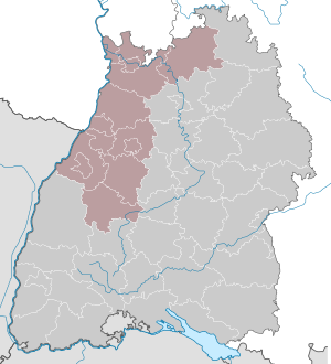
Karlsruhe (region)
Regierungsbezirk in Baden-Württemberg, Germany
Distance: Approx. 2679 meters
Latitude and longitude: 49,8.5
Karlsruhe is one of the four administrative regions (sing. Regierungsbezirk) of Baden-Württemberg, Germany, located in the north-west of the state. It is subdivided into the three regional associations (sing.

Wolfartsweier
Borough of Karlsruhe in Baden-Württemberg, Germany
Distance: Approx. 2503 meters
Latitude and longitude: 48.97444444,8.45361111
Wolfartsweier is a village and a quarter of Karlsruhe, Baden-Württemberg, Germany. Its population is 3,068 (2020). It was first mentioned in 1261 AD under the name of "Wolvoldeswilere".

Durlach
Borough of Karlsruhe in Baden-Württemberg, Germany
Distance: Approx. 578 meters
Latitude and longitude: 48.99916667,8.47
Durlach is a borough of the German city of Karlsruhe with a population of roughly 30,000.

Turmberg
Hil in Durlach, Germany
Distance: Approx. 1582 meters
Latitude and longitude: 48.99677778,8.48547222
The Turmberg (German: "Tower Hill") is a hill (elevation: 256 m) located in Durlach, a suburb of Karlsruhe in Germany. It is home to a castle ruin. The Turmberg can be reached by the Turmbergbahn, a funicular railway.
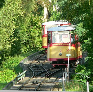
Turmbergbahn
Distance: Approx. 1438 meters
Latitude and longitude: 48.99787222,8.48331111
The Turmbergbahn is a funicular railway in Karlsruhe in Germany. It is the oldest operating funicular in Germany. From Karlsruhe's former center Durlach, the line climbs the Turmberg, which on a clear day provides a lookout point with views of the Rhine Valley, the Palatinate forest and the adjacent parts of Alsace.

Hochschule für Musik Karlsruhe
College of music in Karlsruhe
Distance: Approx. 2842 meters
Latitude and longitude: 49.0046,8.42726
The Hochschule für Musik Karlsruhe (German: University of Music Karlsruhe) is a college of music in Karlsruhe, Germany. Originally the Baden Conservatory of Music, it was elevated to a Hochschule under the direction of Franz Philipp, who led the school from 1924 to 1942.

Karlsruhe-Durlach station
Second largest station in Karlsruhe, Germany
Distance: Approx. 686 meters
Latitude and longitude: 49.001995,8.462423
Karlsruhe-Durlach station is the second largest station in the city of Karlsruhe in the German state of Baden-Württemberg after Karlsruhe Hauptbahnhof. It is used by services of the Karlsruhe Stadtbahn and the Rhine-Neckar S-Bahn, regular regional services and occasional long-distance trains.
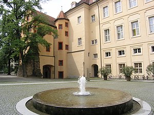
Karlsburg Castle
Distance: Approx. 784 meters
Latitude and longitude: 48.99850278,8.47382778
Karlsburg Castle in the Durlach district of Karlsruhe characterizes the history of the Baden since 1563. Only the Prinzessinnenbau ("Princesses' wing") of the historical building still stands. Pforzheim was the residence of Margrave Charles II, until he decided in 1563 to move to Durlach.

Grötzingen
Stadtteil of Karlsruhe in Baden-Württemberg, Germany
Distance: Approx. 2763 meters
Latitude and longitude: 49.00944444,8.49555556
Grötzingen is a town and eastern suburb of Karlsruhe, Germany. On 31 December 2020 it had a population of 9,156. It contains Augustenburg Castle, a church.

Max-Reger-Institute
Distance: Approx. 856 meters
Latitude and longitude: 48.9988,8.4747
The Max-Reger-Institute (MRI) is a musicological research institute and archive in Karlsruhe, Germany, dedicated to the work of the composer Max Reger, a representative of German music around the turn of the 20th century. An associated foundation, the Elsa-Reger-Stiftung, is named after his wife, Elsa Reger, who founded the foundation and the institute. It has a substantial archive of manuscripts and documents related to Reger.

Grötzingen Jewish Cemetery
Jewish cemetery in Karlsruhe, Baden-Württemberg, Germany
Distance: Approx. 3120 meters
Latitude and longitude: 49.01216667,8.49863889
Grötzingen Jewish Cemetery (German: jüdischer Friedhof Grötzingen or Judengottesacker Grötzingen) is the smallest Jewish burial place in the city of Karlsruhe, Baden-Württemberg, Germany. It is listed as a national heritage site.

Rintheim
District of Karlsruhe
Distance: Approx. 2523 meters
Latitude and longitude: 49.01666667,8.45
Rintheim is a district of Karlsruhe. It is located between Hagsfeld in the north, Oststadt in the west and the Autobahn 5 in the east. The Technologiepark Karlsruhe is located in Rintheim, a center for internet and high-tech companies.
Weather in this IP's area
overcast clouds
15 Celsius
15 Celsius
14 Celsius
16 Celsius
1015 hPa
90 %
1015 hPa
1000 hPa
9821 meters
1.85 m/s
5.68 m/s
216 degree
100 %
07:51:30
18:30:39