Country:
 Netherlands
Region:
City:
Latitude and Longitude:
Time Zone:
Postal Code:
IP information under different IP Channel
ip-api
Country
Region
City
ASN
Time Zone
ISP
Blacklist
Proxy
Latitude
Longitude
Postal
Route
IPinfo
Country
Region
City
ASN
Time Zone
ISP
Blacklist
Proxy
Latitude
Longitude
Postal
Route
MaxMind
Country
Region
City
ASN
Time Zone
ISP
Blacklist
Proxy
Latitude
Longitude
Postal
Route
Luminati
Country
NLRegion
nb
City
vught
ASN
Time Zone
Europe/Amsterdam
ISP
NForce Entertainment B.V.
Latitude
Longitude
Postal
db-ip
Country
Region
City
ASN
Time Zone
ISP
Blacklist
Proxy
Latitude
Longitude
Postal
Route
ipdata
Country
Region
City
ASN
Time Zone
ISP
Blacklist
Proxy
Latitude
Longitude
Postal
Route
Popular places and events near this IP address

Vught
Town and municipality in North Brabant, Netherlands
Distance: Approx. 453 meters
Latitude and longitude: 51.65,5.3
Vught (Dutch pronunciation: [vʏxt] ) is a municipality and a town in the Province of North Brabant in the southern Netherlands, and lies just south of the industrial and administrative centre of 's-Hertogenbosch. Many commuters live there, and in 2004 the town was named "Best place to live" by the Dutch magazine Elsevier.
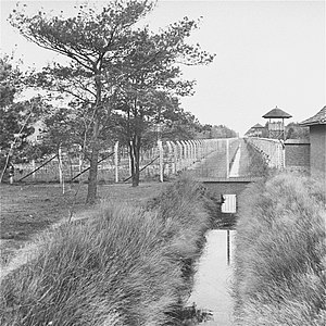
Herzogenbusch concentration camp
Nazi concentration camp in the Netherlands
Distance: Approx. 3205 meters
Latitude and longitude: 51.66583333,5.25888889
Herzogenbusch (German: [ˌhɛʁtsoːɡn̩ˈbʊʃ] ; Dutch: Kamp Vught [kɑmp ˈfʏxt]) was a Nazi concentration camp located in Vught near the city of 's-Hertogenbosch, Netherlands. The camp was opened in 1943 and held 31,000 prisoners. 749 prisoners died in the camp, and the others were transferred to other camps shortly before Herzogenbusch was liberated by the Allied Forces in 1944.

Halder, Netherlands
Hamlet in North Brabant, Netherlands
Distance: Approx. 1157 meters
Latitude and longitude: 51.65,5.31666667
Halder is a hamlet in the Dutch province of North Brabant. It is located in the municipality of Sint-Michielsgestel, between the towns of Sint-Michielsgestel and Vught. The hamlet was first mentioned in 1087 as Herlar, and is a combination of "forest meadow" and "army".
Heikant, Vught
Distance: Approx. 1143 meters
Latitude and longitude: 51.655,5.28472222
Heikant is a former hamlet in the Dutch province of North Brabant. It was located about 1 km west of Vught. The hamlet is mentioned by the 19th-century historian A.J. van der Aa.

Nieuw Vosseveld
Prison in Vught, Netherlands
Distance: Approx. 3173 meters
Latitude and longitude: 51.66333333,5.25777778
Nieuw Vosseveld (officially Penitentiaire Inrichting Vught) is a high-security penal institution in Vught, Netherlands. It is part of the Custodial Institutions Agency of the Ministry of Justice and Security. The two regular prisons consist of a prison for prisoners with management problems, a terrorism section, an institution for systematic crimes, and two prisons for psychiatric crimes.
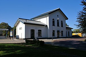
Vught railway station
Railway station in the Netherlands
Distance: Approx. 644 meters
Latitude and longitude: 51.65472222,5.29194444
Vught is a railway station located in Vught, Netherlands. It is situated on the Utrecht–Boxtel railway. The train services are operated by Nederlandse Spoorwegen, it was opened in 1868.
De Heer Kocken
Restaurant in Vught, Netherlands
Distance: Approx. 733 meters
Latitude and longitude: 51.66047778,5.29926389
De Heer Kocken is a restaurant in Vught, Netherlands. It is a fine dining restaurant that was awarded one Michelin star for the period 2009–present. GaultMillau awarded the restaurant 13 out of 20 points.

Maurick Castle
Castle in Vught, the Netherlands
Distance: Approx. 594 meters
Latitude and longitude: 51.658226,5.30645
Maurick Castle is a castle in Vught, Netherlands. It had many famous owners and visitors.

Oud Herlaer
Remains of castle in the Netherlands
Distance: Approx. 1020 meters
Latitude and longitude: 51.659846,5.312569
Oud Herlaer was a castle on the Dommel just east of Vught. All that remains is a farm which incorporates parts of the old castle. While not that much remains of the castle, there are a lot of recent studies about Oud Herlaer and its owners.

Nieuw-Herlaer Castle
Distance: Approx. 1702 meters
Latitude and longitude: 51.650478,5.325181
Nieuw-Herlaer Castle is a manor in Sint-Michielsgestel, the Netherlands. It contains a tower which was part of the preceding castle.

Haanwijk
Estate and nature reserve in the Netherlands
Distance: Approx. 1475 meters
Latitude and longitude: 51.654297,5.322554
Haanwijk is an estate and nature reserve with a manor house near Sint-Michielsgestel in North-Brabant, Netherlands.
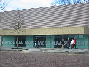
National Monument Camp Vught
Museum in Vught, the Netherlands
Distance: Approx. 3189 meters
Latitude and longitude: 51.66548333,5.25889722
National Monument Camp Vught is a memorial site with a museum located in Vught, in the Dutch province of North Brabant. It commemorates the concentration camp known as Kamp Vught that was established there during World War II. The memorial was founded in 1990, with an exhibition building added in 2002. The monument is located on the northeastern tip of the former camp grounds.
Weather in this IP's area
light rain
14 Celsius
14 Celsius
13 Celsius
15 Celsius
1018 hPa
90 %
1018 hPa
1017 hPa
10000 meters
0.45 m/s
1.34 m/s
150 degree
100 %
08:11:54
18:34:50