46.163.62.179 - IP Lookup: Free IP Address Lookup, Postal Code Lookup, IP Location Lookup, IP ASN, Public IP
Country:
Region:
City:
Location:
Time Zone:
Postal Code:
IP information under different IP Channel
ip-api
Country
Region
City
ASN
Time Zone
ISP
Blacklist
Proxy
Latitude
Longitude
Postal
Route
Luminati
Country
Region
064
City
logatec
ASN
Time Zone
Europe/Ljubljana
ISP
SOFTNET d.o.o.
Latitude
Longitude
Postal
IPinfo
Country
Region
City
ASN
Time Zone
ISP
Blacklist
Proxy
Latitude
Longitude
Postal
Route
IP2Location
46.163.62.179Country
Region
federacija bosne i hercegovine
City
dubrave gornje
Time Zone
Europe/Sarajevo
ISP
Language
User-Agent
Latitude
Longitude
Postal
db-ip
Country
Region
City
ASN
Time Zone
ISP
Blacklist
Proxy
Latitude
Longitude
Postal
Route
ipdata
Country
Region
City
ASN
Time Zone
ISP
Blacklist
Proxy
Latitude
Longitude
Postal
Route
Popular places and events near this IP address

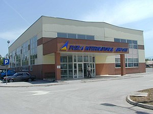
Tuzla International Airport
Airport in Dubrave Gornje, Bosnia and Herzegovina
Distance: Approx. 1478 meters
Latitude and longitude: 44.45861111,18.72472222
Tuzla International Airport (Bosnian: Međunarodni aerodrom Tuzla) (Croatian: Međunarodna zračna luka Tuzla) (Serbian: Међународни аеродром Тузла); (IATA: TZL, ICAO: LQTZ) is an airport in Živinice near Tuzla, Bosnia and Herzegovina. It is the second largest airport in Bosnia and Herzegovina, after Sarajevo International Airport. The airport is known as a low-cost airline hub of Bosnia and Herzegovina since it is used by people from Bosnia, the diaspora and travellers from neighbouring countries Croatia and Serbia.
Tuzla Air Base
Airport
Distance: Approx. 1478 meters
Latitude and longitude: 44.45861111,18.72472222
Tuzla Air Base was a military airport near Tuzla, Bosnia and Herzegovina.
Vršani
Village in Republika Srpska, Bosnia and Herzegovina
Distance: Approx. 3962 meters
Latitude and longitude: 44.5,18.7
Vršani (Cyrillic: Вршани) is a village in the municipality of Bijeljina, Republika Srpska, Bosnia and Herzegovina.

Tojšići
Town in Federation of Bosnia and Herzegovina, Bosnia and Herzegovina
Distance: Approx. 5318 meters
Latitude and longitude: 44.5,18.78333333
Tojšići is a town in the municipality of Kalesija, Bosnia and Herzegovina.
Vukovije Donje
Village in Federation of Bosnia and Herzegovina, Bosnia and Herzegovina
Distance: Approx. 1697 meters
Latitude and longitude: 44.46666667,18.75
Vukovije Donje (Cyrillic: Вуковије Доње) is a village in the municipality of Kalesija, Bosnia and Herzegovina.
Vukovije Gornje
Village in Federation of Bosnia and Herzegovina, Bosnia and Herzegovina
Distance: Approx. 3223 meters
Latitude and longitude: 44.48333333,18.76666667
Vukovije Gornje (Cyrillic: Вуковије Горње) is a village in the municipality of Kalesija, Bosnia and Herzegovina.

Čaklovići Donji
Village in Bosnia and Herzegovina
Distance: Approx. 4819 meters
Latitude and longitude: 44.5146857,18.7296791
Čaklovići Donji is a village in the municipality of Tuzla, Tuzla Canton, Bosnia and Herzegovina.
Čaklovići Gornji
Village in Bosnia and Herzegovina
Distance: Approx. 4848 meters
Latitude and longitude: 44.5122241,18.7509672
Čaklovići Gornji is a village in the municipality of Tuzla, Tuzla Canton, Bosnia and Herzegovina.
Par Selo Gornje
Village in Federation of Bosnia and Herzegovina, Bosnia and Herzegovina
Distance: Approx. 5250 meters
Latitude and longitude: 44.4972727,18.6744332
Par Selo Gornje is a village in the municipality of Tuzla, Tuzla Canton, Bosnia and Herzegovina.
Vršani, Tuzla
Village in Bosnia and Herzegovina
Distance: Approx. 4738 meters
Latitude and longitude: 44.5074785,18.6980359
Vršani is a village in the municipality of Tuzla, Tuzla Canton, Bosnia and Herzegovina.
Dubrave Donje
Village in Federation of Bosnia and Herzegovina, Bosnia and Herzegovina
Distance: Approx. 5031 meters
Latitude and longitude: 44.4778,18.667
Dubrave Donje is a village in the municipality of Živinice, Bosnia and Herzegovina.

Dubrave Gornje
Village in Federation of Bosnia and Herzegovina, Bosnia and Herzegovina
Distance: Approx. 3972 meters
Latitude and longitude: 44.4692,18.6798
Dubrave Gornje is a village in the municipality of Živinice, Bosnia and Herzegovina. It is the location of Tuzla International Airport.
Weather in this IP's area
moderate rain
3 Celsius
-1 Celsius
3 Celsius
5 Celsius
1018 hPa
93 %
1018 hPa
981 hPa
10000 meters
5.66 m/s
11.32 m/s
10 degree
100 %