46.163.57.56 - IP Lookup: Free IP Address Lookup, Postal Code Lookup, IP Location Lookup, IP ASN, Public IP
Country:
Region:
City:
Location:
Time Zone:
Postal Code:
IP information under different IP Channel
ip-api
Country
Region
City
ASN
Time Zone
ISP
Blacklist
Proxy
Latitude
Longitude
Postal
Route
Luminati
Country
Region
064
City
logatec
ASN
Time Zone
Europe/Ljubljana
ISP
SOFTNET d.o.o.
Latitude
Longitude
Postal
IPinfo
Country
Region
City
ASN
Time Zone
ISP
Blacklist
Proxy
Latitude
Longitude
Postal
Route
IP2Location
46.163.57.56Country
Region
nordrhein-westfalen
City
brackwede
Time Zone
Europe/Berlin
ISP
Language
User-Agent
Latitude
Longitude
Postal
db-ip
Country
Region
City
ASN
Time Zone
ISP
Blacklist
Proxy
Latitude
Longitude
Postal
Route
ipdata
Country
Region
City
ASN
Time Zone
ISP
Blacklist
Proxy
Latitude
Longitude
Postal
Route
Popular places and events near this IP address

Bethel Foundation
Psychiatric hospital in Bielefeld, Germany
Distance: Approx. 2965 meters
Latitude and longitude: 52.013259,8.522945
The Bethel Foundation, officially the Bodelschwingh Foundation Bethel (German: von Bodelschwinghsche Stiftungen Bethel as of 2009, previously v. Bodelschwinghsche Anstalten Bethel) is a diaconal (i.e. Protestant charitable) psychiatric hospital in Bethel, formerly a town, today a neighbourhood of Bielefeld, Germany, and the biggest social business in Europe.

6th Infantry Division (Wehrmacht)
Military unit
Distance: Approx. 3442 meters
Latitude and longitude: 52.0175,8.52472222
The 6th Infantry Division (6.

Hünenburg Telecommunication Tower
Distance: Approx. 3439 meters
Latitude and longitude: 52.0148,8.47461
Hünenburg Telecommunication Tower is a 164 metre telecommunication tower of Deutsche Telekom AG on Hüneburg near Bielefeld in Germany It is a concrete tower of FMT 3/72 type. It is closed to the public. The tower was built in 1972 as replacement for a smaller telecommunication tower, built in 1952.

Botanischer Garten Bielefeld
Distance: Approx. 2844 meters
Latitude and longitude: 52.01472222,8.51
The Botanischer Garten Bielefeld (4 hectares) is a municipal botanical garden located beside the southeast edge of the Teutoburger Wald at Am Kahlenberg 16, Bielefeld, North Rhine-Westphalia, Germany. It is open daily and free of charge. The garden was established in 1912 on one hectare.

Quelle station
Railway station in Germany
Distance: Approx. 3147 meters
Latitude and longitude: 52.0005,8.4611
Quelle is a railway station located in Bielefeld, Germany. The station is on the Osnabrück–Brackwede railway. The train services are operated by NordWestBahn.

Quelle-Kupferheide station
Railway station in Germany
Distance: Approx. 1907 meters
Latitude and longitude: 51.9941,8.4766
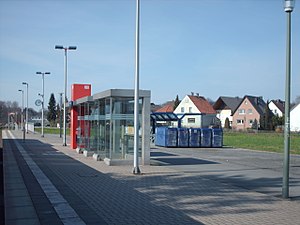
Quelle-Kupferheide is a railway station located in Bielefeld, Germany. The station is on the Osnabrück–Brackwede railway. The train services are operated by NordWestBahn.

Brackwede station
Railway station in Bielefeld, Germany
Distance: Approx. 891 meters
Latitude and longitude: 51.99694444,8.49861111
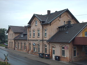
Brackwede station is the second most important station in the city of Bielefeld in the German state of North Rhine-Westphalia, after Bielefeld Hauptbahnhof. It was opened in 1847 with the opening of the Cologne-Minden trunk line. It is classified by Deutsche Bahn as a category 4 station.

Kunsthalle Bielefeld
Art museum
Distance: Approx. 3539 meters
Latitude and longitude: 52.01805556,8.52611111
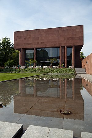
The Kunsthalle Bielefeld is a modern and contemporary art museum in Bielefeld, Germany. It was designed by Philip Johnson in 1968, and paid for by the businessman and art patron Rudolf August Oetker.
Grippenbach
River in Germany
Distance: Approx. 2956 meters
Latitude and longitude: 51.9698,8.4745
Grippenbach is a small river of North Rhine-Westphalia, Germany. It is 2.3 km long and flows into the Sunderbach near Bielefeld-Ummeln.
Sunderbach (Trüggelbach)
River in Bielefeld, Germany
Distance: Approx. 3318 meters
Latitude and longitude: 51.9686,8.4689
Sunderbach is a small river of North Rhine-Westphalia, Germany. It is 2.7 km (1.7 mi) long and is a right tributary of the Trüggelbach. It is one of eight rivers and streams in North Rhine-Westphalia officially recorded under the name Sunderbach.

Tüterbach
River in Germany
Distance: Approx. 3529 meters
Latitude and longitude: 51.9686,8.4647
Tüterbach is a river of North Rhine-Westphalia, Germany.

Natural History Museum, Bielefeld
Natural history museum in Kreuzstrasse in Bielefeld, Germany
Distance: Approx. 3519 meters
Latitude and longitude: 52.01713,8.52836
The Natural History Museum in Bielefeld (German: Naturkunde-Museum Bielefeld) is a natural history museum in the city of Bielefeld in North Rhine-Westphalia, Germany. Since 2003, it was given the additional name namu, which stands for the German words Natur (nature), Mensch (man), and Umwelt (environment). The exhibitions take place in the Spiegelshof, a historical building from the 14th century.
Weather in this IP's area
light rain
1 Celsius
1 Celsius
0 Celsius
2 Celsius
994 hPa
99 %
994 hPa
977 hPa
5414 meters
0.45 m/s
4.02 m/s
96 degree
100 %

