46.163.57.35 - IP Lookup: Free IP Address Lookup, Postal Code Lookup, IP Location Lookup, IP ASN, Public IP
Country:
Region:
City:
Location:
Time Zone:
Postal Code:
IP information under different IP Channel
ip-api
Country
Region
City
ASN
Time Zone
ISP
Blacklist
Proxy
Latitude
Longitude
Postal
Route
Luminati
Country
Region
064
City
logatec
ASN
Time Zone
Europe/Ljubljana
ISP
SOFTNET d.o.o.
Latitude
Longitude
Postal
IPinfo
Country
Region
City
ASN
Time Zone
ISP
Blacklist
Proxy
Latitude
Longitude
Postal
Route
IP2Location
46.163.57.35Country
Region
liepaja
City
vec-liepaja
Time Zone
Europe/Riga
ISP
Language
User-Agent
Latitude
Longitude
Postal
db-ip
Country
Region
City
ASN
Time Zone
ISP
Blacklist
Proxy
Latitude
Longitude
Postal
Route
ipdata
Country
Region
City
ASN
Time Zone
ISP
Blacklist
Proxy
Latitude
Longitude
Postal
Route
Popular places and events near this IP address

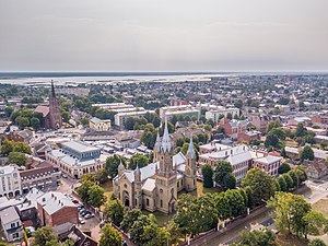
Liepāja
City in Courland, Latvia
Distance: Approx. 2414 meters
Latitude and longitude: 56.51166667,21.01388889
Liepāja (pronounced [liepaːja] ) is a state city in western Latvia, located on the Baltic Sea. It is the largest city in the Kurzeme Region and the third-largest in the country after Riga and Daugavpils. It is an important ice-free port.

Karosta
Neighbourhood of Liepaja, Latvia
Distance: Approx. 1981 meters
Latitude and longitude: 56.55,21.00555556
Karosta is a former Russian Imperial and Soviet naval base on the Baltic Sea, which today is a neighbourhood in Liepāja, Latvia.

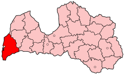
Liepāja district
District of Latvia
Distance: Approx. 2414 meters
Latitude and longitude: 56.51166667,21.01388889
Liepāja district (Latvian: Liepājas rajons) was an administrative division of Latvia, located in the Courland region, in the country's west. Districts were eliminated during the administrative-territorial reform in 2009.
Liepāja Special Economic Zone
Distance: Approx. 2048 meters
Latitude and longitude: 56.53333333,20.98333333
The Liepaja Special Economic Zone (Latvian: Liepājas SEZ) is the only special economic zone in the Baltics consisting of a seaport, industrial area and international airport. Liepāja special economic zone was established in 1997 to develop port operations, cargo handling, logistics, manufacturing and air transportation. The goal of the Liepāja SEZ is to attract investments for the development of the port, manufacturing, and creating new working places.

Liepājas tramvajs
Tram operator in Liepāja, Latvia
Distance: Approx. 1267 meters
Latitude and longitude: 56.52194444,21.01805556
Liepājas tramvajs is a municipal company that operates a single tram line in Liepāja, Latvia. The current double-tracked tram line has a length of 7.9 kilometres (4.9 mi).
Velnciems
Neighbourhood of Liepaja, Latvia
Distance: Approx. 733 meters
Latitude and longitude: 56.53083333,21.02777778
Velnciems (Devil's village) is one of the oldest districts of Liepāja, Latvia. Located near Lauma's district, at the east side of the city.
Ziemeļu priekšpilsēta (Liepāja)
Neighbourhood of Liepaja, Latvia
Distance: Approx. 257 meters
Latitude and longitude: 56.5325,21.01277778
Ziemeļu priekšpilsēta (North suburbs) is a modern neighborhood in Liepāja, Latvia. Located south from Karosta next to Jaunliepāja. In the recent years there has been a high crime rate and it is considered as an unsafe neighborhood.
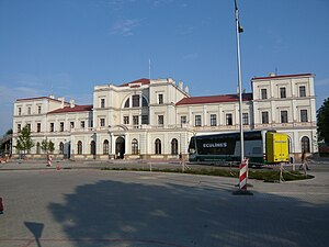
Liepāja Station
Railway station in Liepāja, Latvia
Distance: Approx. 1020 meters
Latitude and longitude: 56.52414167,21.016925
Liepāja Station is the railway station for Liepāja on the Jelgava – Liepāja Railway.

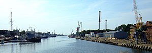
Port of Liepāja
Port in Liepaja, Latvia
Distance: Approx. 1249 meters
Latitude and longitude: 56.53527778,20.99666667
Port of Liepaja (Latvian: Liepājas osta) is a port in Liepāja, Latvia. It handled 7 334 261,80 tonnes of cargo and 39 987 passengers in 2019, making it the third largest port in the country (by territory, number of passengers and amount of cargo handled).
Liepāja Lighthouse
Lighthouse in Liepaja, Latvia
Distance: Approx. 2367 meters
Latitude and longitude: 56.51682778,20.99231944
The Liepāja Lighthouse (Latvian: Liepājas bāka) is a lighthouse located in Liepāja on the Latvian coast of the Baltic Sea.
St. Nicholas Naval Cathedral, Karosta
Church in Liepaja, Latvia
Distance: Approx. 2200 meters
Latitude and longitude: 56.552921,21.012444
The St. Nicholas Naval Cathedral (Latvian: Sv. Nikolaja Jūras katedrāle) (Russian: Свято-Николаевский морской собор) is a Russian Orthodox cathedral church located in Karosta in the north of Liepāja, Latvia.
Jaunliepāja
Neighborhood in Liepāja, Latvia
Distance: Approx. 1497 meters
Latitude and longitude: 56.52,21.01305556
Jaunliepāja is one of the neighbourhoods of Liepāja, Latvia.
Weather in this IP's area
overcast clouds
-2 Celsius
-2 Celsius
-2 Celsius
-2 Celsius
1007 hPa
100 %
1007 hPa
1006 hPa
10000 meters
97 %


