45.94.190.153 - IP Lookup: Free IP Address Lookup, Postal Code Lookup, IP Location Lookup, IP ASN, Public IP
Country:
Region:
City:
Location:
Time Zone:
Postal Code:
IP information under different IP Channel
ip-api
Country
Region
City
ASN
Time Zone
ISP
Blacklist
Proxy
Latitude
Longitude
Postal
Route
Luminati
Country
Region
ni
City
elze
ASN
Time Zone
Europe/Berlin
ISP
Expereo International BV
Latitude
Longitude
Postal
IPinfo
Country
Region
City
ASN
Time Zone
ISP
Blacklist
Proxy
Latitude
Longitude
Postal
Route
IP2Location
45.94.190.153Country
Region
niedersachsen
City
elze
Time Zone
Europe/Berlin
ISP
Language
User-Agent
Latitude
Longitude
Postal
db-ip
Country
Region
City
ASN
Time Zone
ISP
Blacklist
Proxy
Latitude
Longitude
Postal
Route
ipdata
Country
Region
City
ASN
Time Zone
ISP
Blacklist
Proxy
Latitude
Longitude
Postal
Route
Popular places and events near this IP address

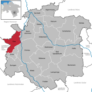
Elze
Town in Lower Saxony, Germany
Distance: Approx. 685 meters
Latitude and longitude: 52.11666667,9.73333333
Elze (German pronunciation: [ˈɛlt͡sə] ) is a town in the district of Hildesheim, in Lower Saxony, Germany. It is situated on the river Leine, approximately 15 km (9.3 mi) west of Hildesheim. The municipality of Elze also comprises the villages of Esbeck, Mehle, Sehlde, Sorsum, Wittenburg and Wülfingen.

Nordstemmen
Municipality in Lower Saxony, Germany
Distance: Approx. 5334 meters
Latitude and longitude: 52.16666667,9.76666667
Nordstemmen is a village and a municipality in the district of Hildesheim, in Lower Saxony, Germany. It is situated on the river Leine, approx. 10 km west of Hildesheim, and 25 km south of Hannover.
Banteln
Ortsteil of Gronau in Lower Saxony, Germany
Distance: Approx. 6217 meters
Latitude and longitude: 52.06805556,9.75555556
Banteln is a village and a former municipality in the district of Hildesheim in Lower Saxony, Germany. Since 1 November 2016, it is part of the town Gronau.
Betheln
Ortsteil of Gronau in Lower Saxony, Germany
Distance: Approx. 4424 meters
Latitude and longitude: 52.11666667,9.8
Betheln is a village and former municipality in the district of Hildesheim, in Lower Saxony, Germany. Since 1 November 2016, it is part of the town of Gronau.
Despetal
Place in Lower Saxony, Germany
Distance: Approx. 6061 meters
Latitude and longitude: 52.1,9.81666667
Despetal is a former municipality in the district of Hildesheim in Lower Saxony, Germany. Since 1 November 2016, it is part of the town Gronau.

Eime, Lower Saxony
Municipality in Lower Saxony, Germany
Distance: Approx. 4567 meters
Latitude and longitude: 52.08333333,9.71666667
Eime is a municipality in the district of Hildesheim in Lower Saxony, Germany.
Gronau (Samtgemeinde)
Distance: Approx. 7013 meters
Latitude and longitude: 52.0667,9.7833
Gronau is a former Samtgemeinde ("collective municipality") in the district of Hildesheim, in Lower Saxony, Germany. Its seat was in the town Gronau. On 1 November 2016 it was merged into the new Samtgemeinde Leinebergland.

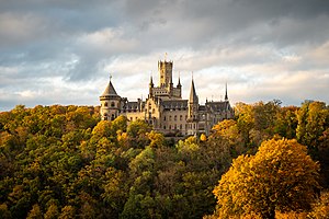
Marienburg Castle (Hanover)
Castle in Pattensen, Lower Saxony, Germany
Distance: Approx. 5911 meters
Latitude and longitude: 52.17229,9.7665
Marienburg Castle is a Gothic revival castle in Lower Saxony, Germany. It is located 15 kilometres (9.3 mi) north-west of Hildesheim, and around 30 kilometres (19 mi) south of Hanover, in the municipality of Pattensen. A summer residence of the House of Welf in the past, it is now owned by the Marienburg Castle Foundation chaired by former owner Ernst August of Hanover but publicly funded in part by the state of Lower Saxony.

Haller (river)
River in Germany
Distance: Approx. 5310 meters
Latitude and longitude: 52.1674,9.7627
Haller is a river of Lower Saxony, Germany. It flows into the Leine near Nordstemmen.

Saale (Leine)
River in Lower Saxony, Germany
Distance: Approx. 1611 meters
Latitude and longitude: 52.13222222,9.75361111
Saale is a river of Lower Saxony, Germany. It is a left tributary of the Leine. Its source is near the village Duingen.
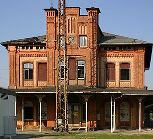
Nordstemmen station
Railway station in Nordstemmen, Germany
Distance: Approx. 6187 meters
Latitude and longitude: 52.16722222,9.79
Nordstemmen station is located on the Hanover–Göttingen railway and the Hildesheim–Löhne railway in the town of Nordstemmen in the German state of Lower Saxony. The station building, constructed by Conrad Wilhelm Hase between 1853 and 1854, has not been used by Deutsche Bundesbahn nor Deutsche Bahn since 1977. Since 2011, the Hildesheim contractor Dirk Bettels has tried in vain to acquire and rehabilitate the grade II heritage-listed station building with public funds.
Leinebergland (Samtgemeinde)
Administrative division in Lower Saxony, Germany
Distance: Approx. 6583 meters
Latitude and longitude: 52.07,9.78
Leinebergland is a Samtgemeinde ("collective municipality") in the district of Hildesheim, in Lower Saxony, Germany. Its seat is in the town Gronau. It was formed on 1 November 2016 by the merger of the former Samtgemeinden Gronau and Duingen.
Weather in this IP's area
overcast clouds
4 Celsius
4 Celsius
3 Celsius
6 Celsius
1033 hPa
65 %
1033 hPa
1023 hPa
10000 meters
0.95 m/s
0.9 m/s
184 degree
100 %
