Country:
 France
Region:
City:
Latitude and Longitude:
Time Zone:
Postal Code:
IP information under different IP Channel
ip-api
Country
Region
City
ASN
Time Zone
ISP
Blacklist
Proxy
Latitude
Longitude
Postal
Route
IPinfo
Country
Region
City
ASN
Time Zone
ISP
Blacklist
Proxy
Latitude
Longitude
Postal
Route
MaxMind
Country
Region
City
ASN
Time Zone
ISP
Blacklist
Proxy
Latitude
Longitude
Postal
Route
Luminati
Country
FRASN
Time Zone
Europe/Paris
ISP
Ielo-liazo Services SAS
Latitude
Longitude
Postal
db-ip
Country
Region
City
ASN
Time Zone
ISP
Blacklist
Proxy
Latitude
Longitude
Postal
Route
ipdata
Country
Region
City
ASN
Time Zone
ISP
Blacklist
Proxy
Latitude
Longitude
Postal
Route
Popular places and events near this IP address

Temple station (Paris Métro)
Metro station in Paris, France
Distance: Approx. 445 meters
Latitude and longitude: 48.866488,2.360595
Temple (French pronunciation: [tɑ̃pl] ) is a station on Paris Métro Line 3, located in the 3rd arrondissement of Paris.

République station
Metro station in Paris, France
Distance: Approx. 198 meters
Latitude and longitude: 48.867503,2.363811
République (French pronunciation: [ʁepyblik] ) is a station on lines 3, 5, 8, 9 and 11 of the Paris Métro. It is located under the Place de la République, at the tripoint border of the 3rd, 10th and 11th arrondissements. It is an important interchange station; its 16.6 million users (2019) make it the seventh busiest out of 302 on the Métro network.

Filles du Calvaire station
Metro station in Paris, France
Distance: Approx. 361 meters
Latitude and longitude: 48.86416667,2.36611111
Filles du Calvaire (French pronunciation: [fij dy kalvɛːʁ]) is a station on Line 8 of the Paris Métro, at the limit between the 3rd and 11th arrondissements.

Goncourt station
Metro station in Paris, France
Distance: Approx. 408 meters
Latitude and longitude: 48.869831,2.370687
Goncourt (French pronunciation: [ɡɔ̃kuʁ] ) is a station on line 11 of the Paris Métro in the 10th and 11th arrondissements. It is named after the nearby rue des Goncourt, which was named after the writers Edmond de Goncourt (1822–1896) and his brother Jules de Goncourt (1830–1870). Edmond de Goncourt left funds to create the Académie Goncourt which awards the Prix Goncourt literary prize.

Cirque d'hiver
Auditorium in Paris, France
Distance: Approx. 455 meters
Latitude and longitude: 48.86337,2.36753
The Cirque d'Hiver ("Winter Circus"), located at 110 rue Amelot (at the juncture of the rue des Filles du Calvaire and rue Amelot, Paris 11ème), has been a prominent venue for circuses, exhibitions of dressage, musical concerts, and other events, including exhibitions of Turkish wrestling and even fashion shows. The theatre was designed by the architect Jacques Ignace Hittorff and was opened by Emperor Napoleon III on 11 December 1852 as the Cirque Napoléon. The orchestral concerts of Jules Etienne Pasdeloup were inaugurated at the Cirque Napoléon on 27 October 1861 and continued for more than twenty years.

Square du Temple
Garden in Paris, France
Distance: Approx. 393 meters
Latitude and longitude: 48.86527778,2.36222222
The Square du Temple is a garden in Paris, France in the 3rd arrondissement, established in 1857. It is one of 24 city squares planned and created by Georges-Eugène Haussmann and Jean-Charles Adolphe Alphand. The Square occupies the site of a medieval fortress in Paris, built by the Knights Templar.
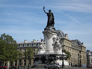
Place de la République
Square in Paris, France
Distance: Approx. 180 meters
Latitude and longitude: 48.86727778,2.36405556
The Place de la République (French pronunciation: [plas də la ʁepyblik]; English: Republic Square; known until 1879 as the Place du Château d'Eau, [plas dy ʃɑto do]) is a square in Paris, located on the border between the 3rd, 10th and 11th arrondissements. The square has an area of 3.4 ha (8.4 acres). Named after the First, Second and Third Republics, it contains a monument, the Monument à la République, which includes a statue of the personification of France, Marianne.

Le Chateaubriand
Restaurant in Paris, France
Distance: Approx. 410 meters
Latitude and longitude: 48.8693,2.3713
Le Chateaubriand (French pronunciation: [lə ʃɑtobʁijɑ̃]) is a restaurant on Avenue Parmentier in Paris, France. Its chef is Iñaki Aizpitarte. Le Chateaubriand eschews traditional Parisian À la carte menus in favor of prix fixe offerings, paired with wines which include biodynamic and organic vintages from South Africa, the United States, Georgia, and France (examples of wine offerings include a Saumur blanc, a Roussillon red, a Volnay, a Meursault, and a Côte-Rôtie).

Théâtre Déjazet
Theatre in Paris, France
Distance: Approx. 208 meters
Latitude and longitude: 48.86611111,2.36444444
The Théâtre Déjazet is a theatre on the boulevard du Temple (popularly known as the 'boulevard du crime') in the 3rd arrondissement of Paris, France. It was founded in 1770 by Comte d'Artois who later was crowned Charles X. It was then closed down and not reopened until 1851. At that time it became a café-concert called the Folies-Mayer, on the site of a former jeu de paume (tennis court).

Alhambra (Paris)
Theatre in Paris, France
Distance: Approx. 427 meters
Latitude and longitude: 48.8706,2.3633
The Alhambra is a theatre which opened in April 2008 at 21, rue Yves-Toudic in the 10th arrondissement of Paris, 300 meters from the site of the old Alhambra-Maurice Chevalier.
École Duperré
Distance: Approx. 405 meters
Latitude and longitude: 48.86528056,2.36201944
The Duperré School of Applied Arts is a public college of art and design. The school is located in the Rue Dupetit-Thouars, in the 3rd arrondissement of Paris, near the Carreau du Temple, in the heart of Le Marais. Duperré School trains students for creative careers in fashion and textiles, as well as environmental and graphic design.

Boulevard du Temple (photograph)
First photograph, a daguerreotype, to show people
Distance: Approx. 276 meters
Latitude and longitude: 48.86863889,2.36325
The Boulevard du Temple photograph of 1838 (or possibly 1837) is an image of a Parisian streetscape and one of the earliest surviving daguerreotype plates produced by Louis Daguerre. Although the image seems to be of a deserted street, it is widely considered to be the first photograph to include an image of a human.
Weather in this IP's area
few clouds
14 Celsius
14 Celsius
13 Celsius
14 Celsius
1010 hPa
91 %
1010 hPa
1005 hPa
10000 meters
4.63 m/s
220 degree
20 %
07:17:43
20:18:53