Country:
Region:
City:
Latitude and Longitude:
Time Zone:
Postal Code:
IP information under different IP Channel
ip-api
Country
Region
City
ASN
Time Zone
ISP
Blacklist
Proxy
Latitude
Longitude
Postal
Route
Luminati
Country
ASN
Time Zone
Europe/Warsaw
ISP
CloudFerro S.A
Latitude
Longitude
Postal
IPinfo
Country
Region
City
ASN
Time Zone
ISP
Blacklist
Proxy
Latitude
Longitude
Postal
Route
db-ip
Country
Region
City
ASN
Time Zone
ISP
Blacklist
Proxy
Latitude
Longitude
Postal
Route
ipdata
Country
Region
City
ASN
Time Zone
ISP
Blacklist
Proxy
Latitude
Longitude
Postal
Route
Popular places and events near this IP address

Senate of Poland
Upper house of the parliament of Poland
Distance: Approx. 579 meters
Latitude and longitude: 52.2256,21.03
The Senate (Polish: Senat) is the upper house of the Polish parliament, the lower house being the Sejm. The history of the Polish Senate stretches back over 500 years; it was one of the first constituent bodies of a bicameral parliament in Europe and existed without hiatus until the final partition of the Polish state in 1795. The contemporary Senate is composed of 100 senators elected by a universal ballot and is headed by the Marshal of the Senate (Marszałek Senatu).

Polish Army Stadium
Polish football stadium
Distance: Approx. 477 meters
Latitude and longitude: 52.22046111,21.04062778
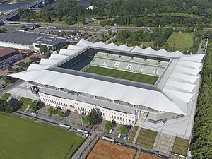
The Polish Army Stadium (Polish: Stadion Wojska Polskiego, pronounced [ˌstadjɔn ˌvɔjska pɔlˈskʲɛɡɔ]), official named the Marshall Józef Piłsudski Legia Warsaw Stadium (Polish: Stadion Legii Warszawa im. Marszałka Józefa Piłsudskiego), is an all-seater, highest fourth category football-specific stadium located at 3 Łazienkowska Street in the Śródmieście district, Powiśle area, within the square of the streets: Łazienkowska, Czerniakowska, Kusocińskiego and Myśliwieck. It is the home ground of Legia Warsaw football club, who have been playing there since 9 August 1930.

Arena COS Torwar
Indoor arena in Warsaw, Poland
Distance: Approx. 348 meters
Latitude and longitude: 52.2225,21.04222222
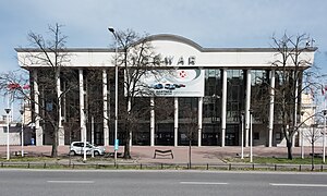
The Central Sports Centre Torwar (formerly known as Hala Torwar, commonly referred to as the Arena COS Torwar) is an indoor arena in Warsaw, Poland. It opened in 1953 and seats 4,824 people in the stands, with up to an additional 1,480 seats available to add on the floor, located at ul. Łazienkowska 6a in Warsaw.

Science Picnic
Distance: Approx. 461 meters
Latitude and longitude: 52.227778,21.034167
The Science Picnic is Europe's largest outdoor science-popularization event organized jointly by Polish Radio and the Copernicus Science Centre. It has been held every year since 1997. A wide range of research fields are represented at the Picnic, including the hard, natural, and social sciences together with the humanities.
Warsaw Open
Tennis tournament
Distance: Approx. 504 meters
Latitude and longitude: 52.22,21.0375
The Warsaw Open, formerly the J&S Cup, was a women's tennis tournament on the WTA Tour held in Warsaw, Poland. Held since 1995, the tournament was played on outdoor clay courts. The event returned for two years to the WTA Tour in 2009 after a year's hiatus but its slot on the tour calendar was taken over by the Brussels Open from 2011.
2006 J&S Cup
Tennis tournament
Distance: Approx. 514 meters
Latitude and longitude: 52.21988889,21.03786111
The 2006 J&S Cup was a Tier II event on the 2006 WTA Tour that run from 1 May until 7 May 2006. It was held in Warsaw, Poland, and was the 11th year that the event was staged. Kim Clijsters won her first Warsaw title and first overall of the year.

Museum of the Castle and Military Hospital at Ujazdów
Local museum in Warsaw, Poland
Distance: Approx. 565 meters
Latitude and longitude: 52.21944444,21.0375
Muzeum Zamku i Szpitala Wojskowego na Ujazdowie is a museum in Warsaw, Poland which opened in 1994. It is located in the Ujazdów Castle, in one of the rooms belonging to the Centre for the Contemporary Art, in the north-west tower of the castle. The exhibition includes objects and photographs related to the history of the Ujazdów Castle and the Ujazdów military hospital including portraits of the castle owners and a cornerstone from 1624.

Żyleta
Northern stand at the Stadion Wojska Polskiego in Warsaw, Poland
Distance: Approx. 415 meters
Latitude and longitude: 52.22111111,21.04083333
Żyleta (Polish pronunciation: [ʐɨˈlɛta], English: the Razor) is a common name of a northern stand at the Stadion Wojska Polskiego in Warsaw, Poland, traditionally occupied by the most spontaneous and fanatical fans of Legia Warsaw football club. Before the stadium renovation (2008–2011), the "old" Żyleta referred only to the center section within the eastern stand of the stadium (occasionally, it would also refer to eastern stand as a whole). There is a special exhibition dedicated to the "old" Żyleta in the Legia club museum.
Stefan Batory 2nd High School (Warsaw)
Public school in Warsaw, Mazovia, Poland
Distance: Approx. 404 meters
Latitude and longitude: 52.222,21.034
Batory High School is a public secondary school founded on 1 September 1918 and located at 6 Myśliwiecka Street in Warsaw, Poland. It is one of the best and most prestigious high schools in Poland. Famous alumni include among others composer Witold Lutosławski and poet and Home Army soldier Krzysztof Kamil Baczyński, killed during the Warsaw Uprising.

Tadeusz Mazowiecki Park (Warsaw)
Urban park in Warsaw, Poland
Distance: Approx. 498 meters
Latitude and longitude: 52.22305556,21.03138889
The Tadeusz Mazowiecki Park, formerly known as the Jazdów Park, is an urban park in Warsaw, Poland, located in the district of Downtown.

Symonowicz Palace
Palace in Warsaw, Poland
Distance: Approx. 413 meters
Latitude and longitude: 52.22766194,21.04147694
The Symonowicz Palace, also known as the Szymonowicz Palace, and Szymonowicz House, is a baroque palace in the city of Warsaw, Poland, located at 37 Solec Street.

General Zbigniew Ścibor-Rylski Monument
Monument in Warsaw, Poland
Distance: Approx. 528 meters
Latitude and longitude: 52.229175,21.03958889
The General Zbigniew Ścibor-Rylski Monument is a monument in the Marshal Edward Rydz-Śmigły Park in Warsaw, Poland. It is dedicated to Zbigniew Ścibor-Rylski, officer of the Polish Armed Forces, who fought in the Warsaw Uprising during the World War II. It was designed by Marcin Nowicki and unveiled on 2 August 2019.
Weather in this IP's area
scattered clouds
5 Celsius
1 Celsius
4 Celsius
6 Celsius
1005 hPa
75 %
1005 hPa
994 hPa
10000 meters
6.71 m/s
260 degree
40 %
07:02:21
15:40:06
