45.92.16.155 - IP Lookup: Free IP Address Lookup, Postal Code Lookup, IP Location Lookup, IP ASN, Public IP
Country:
Region:
City:
Location:
Time Zone:
Postal Code:
ISP:
ASN:
language:
User-Agent:
Proxy IP:
Blacklist:
IP information under different IP Channel
ip-api
Country
Region
City
ASN
Time Zone
ISP
Blacklist
Proxy
Latitude
Longitude
Postal
Route
db-ip
Country
Region
City
ASN
Time Zone
ISP
Blacklist
Proxy
Latitude
Longitude
Postal
Route
IPinfo
Country
Region
City
ASN
Time Zone
ISP
Blacklist
Proxy
Latitude
Longitude
Postal
Route
IP2Location
45.92.16.155Country
Region
florida
City
miami
Time Zone
America/New_York
ISP
Language
User-Agent
Latitude
Longitude
Postal
ipdata
Country
Region
City
ASN
Time Zone
ISP
Blacklist
Proxy
Latitude
Longitude
Postal
Route
Popular places and events near this IP address

Eleventh Street station (Miami)
Miami Metromover station
Distance: Approx. 204 meters
Latitude and longitude: 25.78472222,-80.19083333
Eleventh Street is a Metromover station in the Park West neighborhood of Downtown, Miami, Florida. This station, opened May 26, 1994, is located at the intersection of Northeast Second Avenue and 11th Street, just southeast of the Arts & Entertainment District.

Museum Park station
Miami Metromover station
Distance: Approx. 209 meters
Latitude and longitude: 25.78583333,-80.18777778
Museum Park is a Metromover station located on the southeast corner of Biscayne Boulevard and I-395 in Miami, Florida. Originally opened as Bicentennial Park in 1994 and closed in 1996, the station reopened with the completion of the Pérez Art Museum Miami at the newly renamed eponymous park in 2013. The station is located near the intersection of Biscayne Boulevard (US 1) and Northeast 11th Street, adjacent to the MacArthur Causeway (I-395/Florida A1A).

Kentucky Home
Historic house in Florida, United States
Distance: Approx. 216 meters
Latitude and longitude: 25.78611111,-80.19194444
The Kentucky Home (also known as the Anderson Hotel) was a historic home in Miami, Florida. It was located at 1221 and 1227 Northeast 1st Avenue. On January 4, 1989, it was added to the U.S. National Register of Historic Places, but afterwards it was demolished.
Adrienne Arsht Center for the Performing Arts
Building
Distance: Approx. 273 meters
Latitude and longitude: 25.7876332,-80.1920912
The Adrienne Arsht Center for the Performing Arts of Miami-Dade County is a performing arts center located in Miami, Florida. It is one of the largest performing arts centers in the United States. According to Arts Management Magazine, the Arsht Center presents artists from around the world, innovative programming from its three resident companies and local arts partners, free community events that reflect Miami’s identity and arts education experiences for thousands of Miami children each year.

Phillip and Patricia Frost Museum of Science
Science museum in Miami, Florida, US
Distance: Approx. 232 meters
Latitude and longitude: 25.78527778,-80.18777778
The Phillip and Patricia Frost Museum of Science, formerly known as the Miami Science Museum or Miami Science Museum and Space Transit Planetarium, is a science museum, planetarium, and aquarium located in Miami, Florida, United States. The museum originally opened its Coconut Grove location across from Vizcaya Museum and Gardens in 1960. It relocated to Maurice A. Ferré Park in the downtown area adjacent to the Perez Art Museum Miami in 2017 after the closing of the Coconut Grove location in 2015.

Ten Museum Park
Residential skyscraper in Miami
Distance: Approx. 190 meters
Latitude and longitude: 25.7846,-80.19
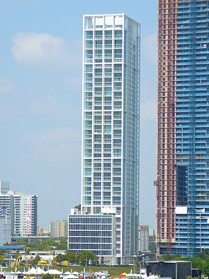
Ten Museum Park is a residential skyscraper in Miami, Florida. It is located in northeastern Downtown, on Biscayne Bay along the west side of Biscayne Boulevard. It was designed by Chad Oppenheim of Oppenheim Architecture + Design.

Marquis Miami
Skyscraper in Miami, Florida, United States
Distance: Approx. 121 meters
Latitude and longitude: 25.785235,-80.190062
Marquis is a skyscraper in Miami, Florida, United States. It is located in northeastern Downtown, on Biscayne Bay along the west side of Biscayne Boulevard. It was topped out in March 2008.

Sears, Roebuck and Company Department Store (Miami, Florida)
United States historic place
Distance: Approx. 105 meters
Latitude and longitude: 25.78722222,-80.19
The Sears, Roebuck and Company Department Store in Miami, Florida was an Art Deco building built in 1929 for Sears, Roebuck and Company. The building was the first known implementation of Art Deco architecture in the county and was spectacular. It was followed a year later by the Shrine Building (Miami, Florida), an application of Art Deco with local Seminole Indian motifs added as an interesting twist.

Melody (building)
Residential in Florida, United States
Distance: Approx. 245 meters
Latitude and longitude: 25.78849,-80.19007
Melody is a residential high-rise building completed in May 2016 in the Arts & Entertainment District neighborhood of Miami, Florida, U.S.A. The building rises about 467 feet (142 m) with 36 floors and contains nearly 500 rental units. It is located about one block from the Adrienne Arsht Center/Omni Metromover and Metrobus hub.

One Thousand Museum
High-rise condominium in Miami, Florida, US
Distance: Approx. 246 meters
Latitude and longitude: 25.7841,-80.19
One Thousand Museum is a high-rise residential condominium in Miami, Florida, United States. The building, which is located at 1000 Biscayne Boulevard, across from Museum Park, was designed by Zaha Hadid Architects. The initial design was started by Zaha Hadid.
Atlantis University
Distance: Approx. 308 meters
Latitude and longitude: 25.789065,-80.189632
Atlantis University is a private for-profit university in Miami. It offers degree programs through its schools of Information Technology, Engineering, Business, Health Care, and Foreign Languages. The university offers graduate, undergraduate, diploma and certification courses both onsite and online.
1974 Miami DEA building collapse
Catastrophic building collapse in Miami
Distance: Approx. 125 meters
Latitude and longitude: 25.786,-80.191
On August 5, 1974, at 10:24 a.m. EDT, a federal office building housing the US Drug Enforcement Administration (DEA) Miami Field Division office in downtown Miami, Florida, United States, collapsed after the roof caved in, causing the deaths of seven DEA employees and injuries to 15 others. Initial speculation centered on a theory that the cars parked on a six-inch-thick slab of concrete on the roof were too heavy, causing the collapse.
Weather in this IP's area
few clouds
21 Celsius
21 Celsius
20 Celsius
21 Celsius
1018 hPa
91 %
1018 hPa
1017 hPa
10000 meters
20 %