45.9.170.170 - IP Lookup: Free IP Address Lookup, Postal Code Lookup, IP Location Lookup, IP ASN, Public IP
Country:
Region:
City:
Location:
Time Zone:
Postal Code:
IP information under different IP Channel
ip-api
Country
Region
City
ASN
Time Zone
ISP
Blacklist
Proxy
Latitude
Longitude
Postal
Route
Luminati
Country
ASN
Time Zone
Europe/Budapest
ISP
Giganet Internet Szolgaltato Kft
Latitude
Longitude
Postal
IPinfo
Country
Region
City
ASN
Time Zone
ISP
Blacklist
Proxy
Latitude
Longitude
Postal
Route
IP2Location
45.9.170.170Country
Region
szabolcs-szatmar-bereg
City
bokony
Time Zone
Europe/Budapest
ISP
Language
User-Agent
Latitude
Longitude
Postal
db-ip
Country
Region
City
ASN
Time Zone
ISP
Blacklist
Proxy
Latitude
Longitude
Postal
Route
ipdata
Country
Region
City
ASN
Time Zone
ISP
Blacklist
Proxy
Latitude
Longitude
Postal
Route
Popular places and events near this IP address

Újfehértó
Town in Szabolcs-Szatmár-Bereg County, Hungary
Distance: Approx. 8843 meters
Latitude and longitude: 47.79888889,21.68333333
Újfehértó (Yiddish, German: Ratzfert) is a small town in Szabolcs-Szatmár-Bereg County, in the Northern Great Plain region of eastern Hungary.
Hajdúhadház
Town in Hajdú-Bihar, Hungary
Distance: Approx. 8361 meters
Latitude and longitude: 47.68333333,21.66666667
Hajdúhadház is a town in Hajdú-Bihar county, in the Northern Great Plain region of eastern Hungary.

Téglás
Town in Hajdú-Bihar, Hungary
Distance: Approx. 5325 meters
Latitude and longitude: 47.71666667,21.68333333
Téglás is a town in Hajdú-Bihar county, in the Northern Great Plain region of eastern Hungary.

Balkány
Place in Northern Great Plain, Hungary
Distance: Approx. 8954 meters
Latitude and longitude: 47.7694,21.8569
Balkány (Hungarian pronunciation: [ˈbɒlkaːɲ]) is a town in Szabolcs-Szatmár-Bereg county, in the Northern Great Plain region of eastern Hungary.

Bököny
Place in Szabolcs-Szatmár-Bereg, Hungary
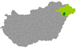
Distance: Approx. 4 meters
Latitude and longitude: 47.73333333,21.75
Bököny is a village in Szabolcs-Szatmár-Bereg county, in the Northern Great Plain region of eastern Hungary.

Érpatak
Place in Szabolcs-Szatmár-Bereg, Hungary
Distance: Approx. 7529 meters
Latitude and longitude: 47.8,21.76666667
Érpatak is a village in Szabolcs-Szatmár-Bereg county, in the Northern Great Plain region of eastern Hungary.

Geszteréd
Place in Szabolcs-Szatmár-Bereg, Hungary
Distance: Approx. 4474 meters
Latitude and longitude: 47.76666667,21.78333333
Geszteréd is a village in Szabolcs-Szatmár-Bereg county, in the Northern Great Plain region of eastern Hungary. It covers an area of 33.52 km2 (13 sq mi) and has a population of 1718 people (2015).

Hajdúhadház District
Districts of Hungary in Hajdú-Bihar
Distance: Approx. 8433 meters
Latitude and longitude: 47.68,21.67
Hajdúhadház (Hungarian: Hajdúhadházi járás) is a district in northern part of Hajdú-Bihar County. Hajdúhadház is also the name of the town where the district seat is found. The district is located in the Northern Great Plain Statistical Region.

Nagykálló District
Districts of Hungary in Szabolcs-Szatmár-Bereg
Distance: Approx. 8357 meters
Latitude and longitude: 47.7833,21.8333
Nagykálló (Hungarian: Nagykállói járás) is a district in southern part of Szabolcs-Szatmár-Bereg County. Nagykálló is also the name of the town where the district seat is found. The district is located in the Northern Great Plain Statistical Region.
Weather in this IP's area
overcast clouds
10 Celsius
7 Celsius
10 Celsius
10 Celsius
1009 hPa
84 %
1009 hPa
992 hPa
10000 meters
6.16 m/s
15.37 m/s
202 degree
100 %