Country:
 Malta
MaltaRegion:
City:
Latitude and Longitude:
Time Zone:
Postal Code:
IP information under different IP Channel
ip-api
Country
Region
City
ASN
Time Zone
ISP
Blacklist
Proxy
Latitude
Longitude
Postal
Route
IPinfo
Country
Region
City
ASN
Time Zone
ISP
Blacklist
Proxy
Latitude
Longitude
Postal
Route
MaxMind
Country
Region
City
ASN
Time Zone
ISP
Blacklist
Proxy
Latitude
Longitude
Postal
Route
Luminati
Country
MTASN
Time Zone
Europe/Malta
ISP
Melita Limited
Latitude
Longitude
Postal
db-ip
Country
Region
City
ASN
Time Zone
ISP
Blacklist
Proxy
Latitude
Longitude
Postal
Route
ipdata
Country
Region
City
ASN
Time Zone
ISP
Blacklist
Proxy
Latitude
Longitude
Postal
Route
Popular places and events near this IP address

Grandmaster's Palace, Valletta
Palace in Malta
Distance: Approx. 51 meters
Latitude and longitude: 35.89861111,14.51416667
The Grandmaster's Palace (Maltese: Il-Palazz tal-Granmastru), officially known as The Palace (Maltese: Il-Palazz), is a palace in Valletta, Malta. It was built between the 16th and 18th centuries as the palace of the Grand Master of the Order of St. John, who ruled Malta from 1530 to 1798, and was also known as the Magisterial Palace (Maltese: Palazz Maġisterjali).
Christ the Redeemer Church (Valletta, Malta)
Church in Valletta, Malta
Distance: Approx. 80 meters
Latitude and longitude: 35.89911111,14.51544444
Christ the Redeemer Church is a church in Valletta, the capital of Malta. It stands as a corner house number 146 on St Christopher Street.
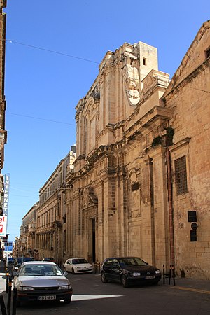
Church of the Jesuits, Valletta
Church in Valletta, Malta
Distance: Approx. 78 meters
Latitude and longitude: 35.8984,14.5152
The Church of the Circumcision of Our Lord (Maltese: Knisja taċ-Ċirkonċiżjoni tal-Mulej), also known as the Church of the Jesuits (Maltese: Knisja tal-Ġiżwiti) or the Church of the University (Maltese: Knisja tal-Università), is one of the oldest and largest churches in Valletta, Malta. It was originally built between 1593 and 1609 by the Jesuit order, and it is located adjacent to the Old University Building, which originally housed a Jesuit college known as the Collegium Melitense. The church was rebuilt in the Baroque style by Francesco Buonamici after suffering extensive damage in an explosion in 1634.

Palace Armoury
Distance: Approx. 64 meters
Latitude and longitude: 35.89888889,14.51388889
The Palace Armoury (Maltese: L-Armerija tal-Palazz) is an arms collection housed at the Grandmaster's Palace in Valletta, Malta. It was the main armoury of the Order of St. John in the 17th and 18th centuries, and as such it was the last arsenal established by a crusader military order.

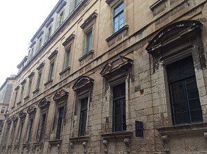
Messina Palace
Distance: Approx. 88 meters
Latitude and longitude: 35.89963889,14.51494444
The Messina Palace, also known as Palazzo Messina, is a palace located at No 141 and 141A Strada San Cristoforo (St. Christopher Street) in Valletta, Malta. It was built by Fra Pietro La Rocca, Prior of Santo Stefano, towards the end of the 16th century and was once part of a grander palace called Casa Rocca Grande.
Collegium Melitense
Jesuit college in Hospitaller Malta
Distance: Approx. 107 meters
Latitude and longitude: 35.89833333,14.51555556
The Collegium Melitense was a Jesuit college in Valletta, Hospitaller Malta, which existed between 1592 and 1769. Lectures at the educational institution began in 1593, and it moved to a purpose-built building adjacent to a Jesuit church in 1597. The 17th century saw an expansion of its curriculum and an increase in the number of students in the college, and in 1727 it was recognised as a university and subsequently it also became known as the Academia Parthenia.

Crown Colony of Malta
British colony in Europe from 1813 to 1964
Distance: Approx. 64 meters
Latitude and longitude: 35.8986,14.514
The Crown Colony of the Island of Malta and its Dependencies (commonly known as the Crown Colony of Malta or simply Malta) was the British colony in the Maltese islands, today the modern Republic of Malta. It was established when the Malta Protectorate was transformed into a British Crown colony in 1813, and this was confirmed by the Treaty of Paris in 1814.

Church of Our Lady of Damascus, Valletta
Church in Valletta, Malta
Distance: Approx. 6 meters
Latitude and longitude: 35.89886111,14.51463889
The Church of Our Lady of Damascus is a Greek Catholic Church in Valletta, in Malta, observing the Byzantine rite. It is also called Id-Damaxxena.
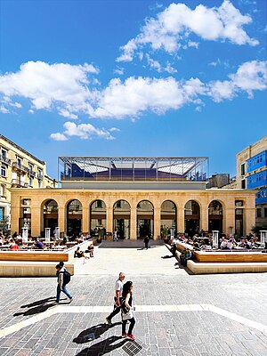
Is-Suq tal-Belt
19th-century market in Valletta, Malta
Distance: Approx. 111 meters
Latitude and longitude: 35.89791667,14.51441667
Is-Suq tal-Belt (IPA: [ɪs suːʔ tɐl bɛlt]; Maltese for "City Market" or "Valletta Market"), also known as the Covered Market, is a 19th-century market hall located in Valletta, Malta. It is notable for being the first building in Malta to be constructed mostly of iron. The building was severely damaged in World War II, and the rebuilding was insensitive to the original structure.
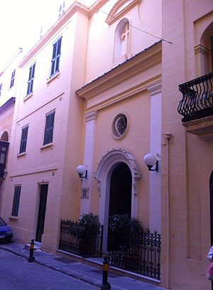
Malta Postal Museum
Postal museum in Malta, VLT
Distance: Approx. 34 meters
Latitude and longitude: 35.89861111,14.51472222
The Malta Postal Museum (Maltese: Mużew tal-Posta ta' Malta) is a postal museum in Valletta, Malta. It is run by the postal operator MaltaPost, and it was inaugurated on 17 June 2016. The museum is housed in a restored 20th-century townhouse in the centre of Valletta, close to the Grandmaster's Palace and the Church of Our Lady of Damascus.
Old University Building, Valletta
Educational building in Valletta, Malta
Distance: Approx. 107 meters
Latitude and longitude: 35.89833333,14.51555556
The Old University Building (Maltese: L-Università l-Qadima or L-Università l-Antika), also known as the Valletta Campus, is the original campus of the University of Malta, located adjacent to the Church of the Jesuits in Valletta, Malta. Construction of the building began in 1595, and it originally housed a Jesuit college known as the Collegium Melitense Societatis Jesu. The building had to be repaired after being damaged in an explosion in 1634 and an earthquake in 1693.

Church and Monastery of St Catherine, Valletta
Church in Valletta, Malta
Distance: Approx. 108 meters
Latitude and longitude: 35.89983333,14.51491667
St Catherine's Monastery (Maltese: Monasteru Santa Katerina ta' Lixandra) is a monastery in Valletta, Malta which houses cloistered nuns of the Second Order of Saint Augustine. It incorporates the Church of the Presentation of Our Lady (Maltese: Knisja tal-Preżentazzjoni tal-Madonna), which is more commonly known as the Church of St Catherine (Maltese: Knisja ta' Santa Katerina). The church and monastery were built in the 18th century and they replaced a previous monastery which had been housed in a 16th-century palace.
Weather in this IP's area
clear sky
22 Celsius
23 Celsius
22 Celsius
23 Celsius
1013 hPa
88 %
1013 hPa
1009 hPa
10000 meters
1.03 m/s
300 degree
06:47:45
19:03:39