45.87.224.230 - IP Lookup: Free IP Address Lookup, Postal Code Lookup, IP Location Lookup, IP ASN, Public IP
Country:
Region:
City:
Location:
Time Zone:
Postal Code:
ISP:
ASN:
language:
User-Agent:
Proxy IP:
Blacklist:
IP information under different IP Channel
ip-api
Country
Region
City
ASN
Time Zone
ISP
Blacklist
Proxy
Latitude
Longitude
Postal
Route
db-ip
Country
Region
City
ASN
Time Zone
ISP
Blacklist
Proxy
Latitude
Longitude
Postal
Route
IPinfo
Country
Region
City
ASN
Time Zone
ISP
Blacklist
Proxy
Latitude
Longitude
Postal
Route
IP2Location
45.87.224.230Country
Region
tipperary
City
templemore
Time Zone
Europe/Dublin
ISP
Language
User-Agent
Latitude
Longitude
Postal
ipdata
Country
Region
City
ASN
Time Zone
ISP
Blacklist
Proxy
Latitude
Longitude
Postal
Route
Popular places and events near this IP address
Garda Síochána College
Irish police training college
Distance: Approx. 622 meters
Latitude and longitude: 52.79166667,-7.84166667
The Garda Síochána College is the education and training college of the Garda Síochána (Irish police service). It is located at McCan Barracks, Templemore, County Tipperary in Ireland. The college has been in Templemore since 1964.
Templemore
Town in County Tipperary, Ireland
Distance: Approx. 646 meters
Latitude and longitude: 52.8,-7.83
Templemore (Irish: An Teampall Mór, meaning 'the big church') is a town in County Tipperary, Ireland. It is a civil parish in the historical barony of Eliogarty. It is part of the parish of Templemore, Clonmore and Killea in the Roman Catholic Archdiocese of Cashel and Emly.

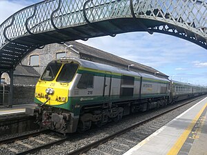
Templemore railway station
Station in County Tipperary, Ireland
Distance: Approx. 992 meters
Latitude and longitude: 52.79027778,-7.82111111
Templemore railway station is a mainline railway station situated 2 km from the town of Templemore, Ireland. The station is on the Dublin-Cork railway line.
Loughmore–Castleiney GAA
Distance: Approx. 4107 meters
Latitude and longitude: 52.7707,-7.78757222
Loughmore–Castleiney GAA is a Gaelic Athletic Association club in County Tipperary, Ireland. The club competes in the Mid-Tipperary division of Tipperary GAA, and draws its players and support from the parish of the same name. The area comprises the villages of Loughmore and Castleiney with their surrounding hinterland.
Loughmore
Village in Munster, Ireland
Distance: Approx. 4172 meters
Latitude and longitude: 52.757444,-7.827223
Loughmore, officially Loughmoe ( lokh-MOH; Irish: Luach Maigh or Luachma), is a village in County Tipperary, Ireland. The village is best known for Loughmoe Castle, seat of the Barons of Loughmoe. It is one half of the parish of Loughmore-Castleiney in the Roman Catholic Archdiocese of Cashel and Emly.

JK Brackens GAA Club
Distance: Approx. 498 meters
Latitude and longitude: 52.79902778,-7.83574444
JK Brackens is a Gaelic Athletic Association club serving the parish of Templemore, Clonmore and Killea in County Tipperary, Ireland. JK Brackens compete in the county Tipperary GAA and Mid-Tipperary divisional competitions and is one of only two clubs in Tipperary that consistently complete at senior level in both the hurling and gaelic football. The club is also nationally renowned as one of the country's leading GAA Scór clubs.

Castleiney
Village in Munster, Ireland
Distance: Approx. 3142 meters
Latitude and longitude: 52.786,-7.7895
Castleiney, officially Castleleiny and historically "Castlelyny" (Irish: Caisleán Laighnigh), is a village in County Tipperary, Ireland. It is one half of the Roman Catholic parish of Loughmore-Castleiney. It is in the barony of Eliogarty.

McCan Barracks
Distance: Approx. 661 meters
Latitude and longitude: 52.79158,-7.84226
McCan Barracks (Irish: Dún Mhic Cana) is the site of two agents of the Irish state: the Garda Síochána College and the Defence Forces. It is located in Templemore, County Tipperary, Ireland. It is named after Pierce McCan.
Loughmoe Castle
Historic site in County Tipperary, Ireland
Distance: Approx. 4455 meters
Latitude and longitude: 52.7549316,-7.82644719
Loughmoe Castle (Irish: Caisláin Luach Magh, also spelt Loughmore Castle) is a ruined castle at Loughmore Village, near Templemore in County Tipperary, Ireland. The castle was the ancestral home of the Purcell family, the Barons of Loughmoe.
Killea, County Tipperary
Village in Munster, Ireland
Distance: Approx. 4171 meters
Latitude and longitude: 52.823367,-7.873821
Killea (Irish: Cill Aodha) is a village in County Tipperary, Ireland. The village lies off the N62 road, 5 km from Templemore. It is one of eleven civil parishes in the historical barony of Ikerrin.
Garda College Museum and Visitor Centre
Police museum in McCann Barracks, Templemore
Distance: Approx. 646 meters
Latitude and longitude: 52.790396,-7.840345
The Garda College Museum and Visitor Centre (Irish: Mhúsaem an Coláiste Garda Síochána agus Ionad Cuartaíochta) was a police museum located in the chapel of the Garda Síochána College at McCan Barracks, Templemore, County Tipperary, Ireland where members of the Garda Síochána (the Irish police service) are educated and trained. The museum was popular with Transition Year school groups from the wider Munster area, as well as members of local Active Retirement Associations.

Templemore Town Hall
Municipal building in Templemore, County Tipperary, Ireland
Distance: Approx. 212 meters
Latitude and longitude: 52.7966,-7.8341
Templemore Town Hall (Irish: Halla an Bhaile An Teampall Mór), is a municipal building in Main Street, Templemore, County Tipperary, Ireland. As of May 2023, it was being converted into a library and enterprise and cultural centre.
Weather in this IP's area
broken clouds
5 Celsius
5 Celsius
5 Celsius
5 Celsius
1006 hPa
95 %
1006 hPa
988 hPa
10000 meters
1.28 m/s
1.17 m/s
264 degree
64 %

