Country:
 Austria
Region:
City:
Latitude and Longitude:
Time Zone:
Postal Code:
IP information under different IP Channel
ip-api
Country
Region
City
ASN
Time Zone
ISP
Blacklist
Proxy
Latitude
Longitude
Postal
Route
IPinfo
Country
Region
City
ASN
Time Zone
ISP
Blacklist
Proxy
Latitude
Longitude
Postal
Route
MaxMind
Country
Region
City
ASN
Time Zone
ISP
Blacklist
Proxy
Latitude
Longitude
Postal
Route
Luminati
Country
ATASN
Time Zone
Europe/Vienna
ISP
Bundesministerium fuer europaeische und internationale Angelegenheiten
Latitude
Longitude
Postal
db-ip
Country
Region
City
ASN
Time Zone
ISP
Blacklist
Proxy
Latitude
Longitude
Postal
Route
ipdata
Country
Region
City
ASN
Time Zone
ISP
Blacklist
Proxy
Latitude
Longitude
Postal
Route
Popular places and events near this IP address
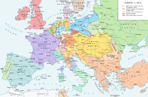
Congress of Vienna
1814–1815 meetings to create a peace plan for Europe
Distance: Approx. 120 meters
Latitude and longitude: 48.2085,16.3638
The Congress of Vienna of 1814–1815 was a series of international diplomatic meetings to discuss and agree upon a possible new layout of the European political and constitutional order after the downfall of the French Emperor Napoleon Bonaparte. Participants were representatives of all European powers (other than the Ottoman Empire) and other stakeholders. The Congress was chaired by Austrian statesman Klemens von Metternich, and was held in Vienna from September 1814 to June 1815.
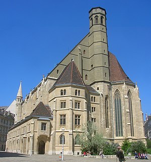
Minoritenkirche (Vienna)
Distance: Approx. 82 meters
Latitude and longitude: 48.2094,16.3636
The Minoritenkirche (English: Friars Minor Conventual Church, related to the monastic Order of Friars Minor Conventual monks), formally called Italienische Nationalkirche Maria Schnee (English: Italian National Church of Mary of the Snows, related to the Italian Congregation who was the owner of this church), was built in French Gothic style in the Altstadt or First District of Vienna, Austria. The site on which the church is built was given to followers of Francis of Assisi in 1224. The foundation stone was laid by King Ottokar II of Bohemia in 1276.

Ministry of the Interior (Austria)
Distance: Approx. 88 meters
Latitude and longitude: 48.20916667,16.36583333
In Austria, the Ministry of the Interior (German: Bundesministerium für Inneres, colloquially Innenministerium, abbreviated: BMI) is a federal government agency serving as the interior ministry of the Austrian government. It is chiefly responsible for the public security, but also deals with matters relating to citizenship, elections, referendums, plebiscites and the alternative civilian service. The Ministry of the Interior is considered one of the most important ministries in Austria It operates and oversees the vast majority of the country's law enforcement agencies, including the Federal Police, the Criminal Police Office (BKA), the Directorate State Protection and Intelligence Service (DSN), the Bureau for Anticorruption (BAK), the Cobra Mission Command (EKO Cobra), the Aerial Police Force, and the Special Observatory Unit (SEO).

Café Central
Building in Vienna, Austria
Distance: Approx. 107 meters
Latitude and longitude: 48.21027778,16.36527778
Café Central is a traditional Viennese café located at Herrengasse 14 in the Innere Stadt first district of Vienna, Austria. The café occupies the ground floor of the former Bank and Stockmarket Building, today called the Palais Ferstel after its architect Heinrich von Ferstel.
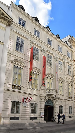
Palais Mollard-Clary
Distance: Approx. 43 meters
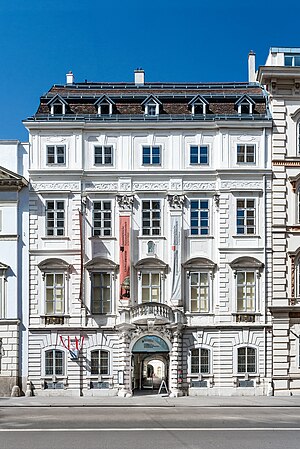
Latitude and longitude: 48.20944444,16.36527778
Palais Mollard-Clary is a Baroque palace in Vienna, Austria. It is located in the first district Innere Stadt, at Herrengasse 9. It was built from 1686 to 1689 for Imperial Count Franz Maximilian von Mollard (1621-1690).

Palais Modena
Distance: Approx. 106 meters
Latitude and longitude: 48.209,16.366
Palais Modena is a palace in Vienna, Austria. It was built and owned by the Habsburgs of the Austria-Este branch of the family. Today it houses offices of the Federal Ministry of the Interior.
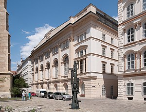
Palais Niederösterreich
Building in Vienna, Austria
Distance: Approx. 67 meters
Latitude and longitude: 48.21,16.36472222
Palais Niederösterreich, historically known as the Niederösterreichisches Landeshaus (Estates House of Lower Austria), is a historical building in Vienna. The building housed the estates general of the state of Lower Austria until 1848. After 1861, the state assembly and some state government ministries occupied it until 1997, when St.
Herrengasse
Distance: Approx. 91 meters
Latitude and longitude: 48.20972222,16.36583333
The Herrengasse (meaning in German language: "Street of the Lords" or "Lords Lane") is a street in Vienna, located in the first district Innere Stadt.

Minoritenplatz
Square in Vienna
Distance: Approx. 30 meters
Latitude and longitude: 48.20926111,16.36435556
The Minoritenplatz is one of the oldest public squares in Vienna. It is located in the first district Innere Stadt, and is dominated by the Minoritenkirche church, after which the square is named. The church itself was constructed by the Greyfriars (Minoriten), after the Austrian Duke Leopold VI of Austria invited them to Austria in 1224.
Esperanto Museum and Collection of Planned Languages
Language museum in Vienna, Austria
Distance: Approx. 43 meters
Latitude and longitude: 48.20944444,16.36527778
The Esperanto Museum and Collection of Planned Languages (German: Esperantomuseum und Sammlung für Plansprachen, Esperanto: Esperantomuzeo kaj kolekto por planlingvoj), commonly known as the Esperanto Museum, is a museum for Esperanto and other constructed languages in Vienna, Austria. It was founded in 1927 by Hofrat Hugo Steiner and was incorporated into the Austrian National Library as an independent collection in 1928. Today, it is a museum, library, documentation center, and archive.

Globe Museum
Distance: Approx. 44 meters
Latitude and longitude: 48.20930556,16.36527778
The Globe Museum (German: Globenmuseum) is a museum in the Palais Mollard, Vienna, Austria, part of the Austrian National Library. It was opened in 1956, and is the only public museum in the world devoted to globes, being three-dimensional models of Earth or other celestial bodies, or spherical representations of the celestial sphere.
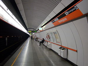
Herrengasse station
Vienna U-Bahn station
Distance: Approx. 60 meters
Latitude and longitude: 48.2093,16.3655
Herrengasse is a station on U3 of the Vienna U-Bahn. It is located in the Innere Stadt District. It opened in 1991.
Weather in this IP's area
broken clouds
12 Celsius
11 Celsius
11 Celsius
15 Celsius
1022 hPa
69 %
1022 hPa
1000 hPa
10000 meters
5.66 m/s
130 degree
75 %
07:20:11
17:58:23