Country:
 Denmark
Region:
City:
Latitude and Longitude:
Time Zone:
Postal Code:
IP information under different IP Channel
ip-api
Country
Region
City
ASN
Time Zone
ISP
Blacklist
Proxy
Latitude
Longitude
Postal
Route
IPinfo
Country
Region
City
ASN
Time Zone
ISP
Blacklist
Proxy
Latitude
Longitude
Postal
Route
MaxMind
Country
Region
City
ASN
Time Zone
ISP
Blacklist
Proxy
Latitude
Longitude
Postal
Route
Luminati
Country
DKRegion
84
City
copenhagen
ASN
Time Zone
Europe/Copenhagen
ISP
Tube-Hosting
Latitude
Longitude
Postal
db-ip
Country
Region
City
ASN
Time Zone
ISP
Blacklist
Proxy
Latitude
Longitude
Postal
Route
ipdata
Country
Region
City
ASN
Time Zone
ISP
Blacklist
Proxy
Latitude
Longitude
Postal
Route
Popular places and events near this IP address

Sundbyøster
Distance: Approx. 456 meters
Latitude and longitude: 55.66111111,12.61111111
Sundbyøster (Danish pronunciation: [sɔnpyˈøstɐ]) is one of the 15 administrative, statistical, and tax city districts (bydele) comprising the municipality of Copenhagen, Denmark. It lies on the southeast border of the municipality on the island of Amager. It covers an area of 8.60 km2, has a population of 48,673 and a population density of 5,658 per km2, which makes it the most populated district in Copenhagen.

Lergravsparken station
Copenhagen metro station
Distance: Approx. 83 meters
Latitude and longitude: 55.66222222,12.61694444
Lergravsparken station is a deep-level Copenhagen Metro station in the East Amager district of Copenhagen, Denmark. It is located on Øresundsvej in a corner of the public park Lergravsparken from which it takes its name. It opened in 2002.

Øresund station
Copenhagen metro station
Distance: Approx. 655 meters
Latitude and longitude: 55.66166667,12.62861111
Øresund station is a station on the Copenhagen Metro, located in the Sundbyøster district of Copenhagen. It opened on 28 September 2007. The station serves the M2 line, in fare zone 3.

Amager Hospital
Hospital in Capital Region, Denmark
Distance: Approx. 803 meters
Latitude and longitude: 55.65489722,12.62041111
Amager Hospital is located in Denmark on the island of Amager in Copenhagen. It was founded on 1 April 1997 with the merger of Skt. Elisabeth Hospital and Sundby Hospital.
Kofoeds School
Distance: Approx. 583 meters
Latitude and longitude: 55.66722222,12.6175
Kofoeds School (Danish: Kofoeds Skole) in Copenhagen, Denmark, is an organization carrying out social work for adults according to the "social pedagogical" principle of personal and vocational empowerment. The school, founded in 1928, bases its work on Christian and humanitarian principles and among other things, the Danish folk high school movement. It offers education, workshop activities, counseling, accommodation, emergency assistance and relief measures.
Amager Øst
District of Copenhagen
Distance: Approx. 449 meters
Latitude and longitude: 55.6625,12.6253
Amager Øst (English: Amager East) is one of the 10 official districts of Copenhagen Municipality, Denmark. It encompasses the part of Copenhagen located on the island of Amager, east of the major shopping street Amagerbrogade.Prior to an administrative reform in 2006–08, the district was known as Sundbyøster. Amager Øst holds within its limits a heterogeneous mixture of areas, to the north Amagerbro, straddling the border with Amager Vest, is a dense "-bro district"-style residential neighbourhoods while other areas are dominated by allotments, Single-family houses or, sometimes abandoned, industrial sites.

Sundby Church
Church in Copenhagen, Denmark
Distance: Approx. 822 meters
Latitude and longitude: 55.66083333,12.60527778
Sundby Church (Danish: Sundby Kirke) is a Church of Denmark parish church located on Amagerbrogade in Copenhagen, Denmark. Completed in 1870 to designs by Hans Jørgen Holm, it is the oldest church on the northern part of Amager.

Holmbladsgade
Distance: Approx. 830 meters
Latitude and longitude: 55.665,12.6061
Holmbladsgade is one of the most lively streets in the Amagerbro district of Copenhagen, Denmark, connecting Amagerbrogade to Strandlodsvej on the east coast of Amager. The surrounding neighbourhood is variously referred to as Holmbladsgadekvarteret (literally "The Holmbladsgade neighbourhood"), Amagerbro or Sundby North.

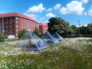
Prismen
Distance: Approx. 669 meters
Latitude and longitude: 55.666444,12.611039
Prismen (literally "The Crystal") is a multifunctional sports and cultural venue in Holmbladsgade on Amager in Copenhagen, Denmark. It was inaugurated in 2006 to a design by Dorte Mandrup.
Philip's Church, Copenhagen
Church in Copenhagen, Denmark
Distance: Approx. 718 meters
Latitude and longitude: 55.65555556,12.61777778
Philip's Church (Danish: Filips Kirke) is a Church of Denmark parish church on Amager in Copenhagen, Denmark.
Lergravsparken
Park in Copenhagen Municipality, Denmark
Distance: Approx. 44 meters
Latitude and longitude: 55.6618,12.6188
Lergravsparken (Lit.: The Clay Pit Park) is a public park situated on the north side of Øresundsvej in the East Amager district of Copenhagen, Denmark. It is bounded by Østrigsgade to the west, Lergravsvej to the north and Strandlodsvej to the east. Lergravsparken metro station is located in a corner of the park.

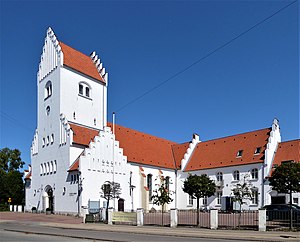
All Saints' Church, Copenhagen
Church in Copenhagen, Denmark
Distance: Approx. 169 meters
Latitude and longitude: 55.6624,12.6156
All Saints' Church (Danish: Allehelgens Kirke) is a church on Ungarnsgade in the Amager district of Copenhagen.
Weather in this IP's area
light intensity drizzle rain
14 Celsius
14 Celsius
12 Celsius
14 Celsius
989 hPa
96 %
989 hPa
988 hPa
10000 meters
4.63 m/s
170 degree
40 %
07:30:26
18:22:09