Country:
 Netherlands
Region:
City:
Latitude and Longitude:
Time Zone:
Postal Code:
IP information under different IP Channel
ip-api
Country
Region
City
ASN
Time Zone
ISP
Blacklist
Proxy
Latitude
Longitude
Postal
Route
IPinfo
Country
Region
City
ASN
Time Zone
ISP
Blacklist
Proxy
Latitude
Longitude
Postal
Route
MaxMind
Country
Region
City
ASN
Time Zone
ISP
Blacklist
Proxy
Latitude
Longitude
Postal
Route
Luminati
Country
NLRegion
nb
City
riel
ASN
Time Zone
Europe/Amsterdam
ISP
Qonnected B.V.
Latitude
Longitude
Postal
db-ip
Country
Region
City
ASN
Time Zone
ISP
Blacklist
Proxy
Latitude
Longitude
Postal
Route
ipdata
Country
Region
City
ASN
Time Zone
ISP
Blacklist
Proxy
Latitude
Longitude
Postal
Route
Popular places and events near this IP address

Goirle
Municipality in North Brabant, Netherlands
Distance: Approx. 3752 meters
Latitude and longitude: 51.51666667,5.06666667
Goirle (pronounced [ˈɣoːrlə] ) is a municipality and town in the southern Netherlands, in the province of North Brabant. Part of the suburban area of the city of Tilburg, it shares with it its phone area code and public transport system. The municipality also includes the villages of Breehees and Riel.
Tilburg University
Public university in the Netherlands
Distance: Approx. 4418 meters
Latitude and longitude: 51.56277778,5.04194444
Tilburg University is a public research university specializing in the social and behavioral sciences, economics, law, business sciences, theology and humanities, located in Tilburg in the southern part of the Netherlands. Tilburg University has a student population of about 19,500 students. Tilburg University has 66 Bachelors & Master's programs, of which 43 are offered in English.

Willem II College
Distance: Approx. 5076 meters
Latitude and longitude: 51.5413,5.0845
Koning Willem II College is a school in Tilburg in the Netherlands. It was established in 1866 and is named after King Willem II. The school was founded in the former royal palace in Tilburg, the present City Hall, of which the construction was commissioned by King William II himself. In 1934 the school moved from the former palace to the new location a new and much bigger building at the Ringbaan Oost in Tilburg.

Westpoint Tower
Residential condominiums in Tilburg, Netherlands
Distance: Approx. 5073 meters
Latitude and longitude: 51.56,5.0652
Westpoint Tower (Dutch: Westpoint-woontoren) is the tallest residential building in Tilburg, Netherlands. It is 141.6 metres tall, and has 48 floors. Construction of Westpoint Tower was completed in 2004.

Koning Willem II Stadion
Distance: Approx. 4013 meters
Latitude and longitude: 51.54277778,5.06694444
Koning Willem II Stadion (Dutch pronunciation: [ˌkoːnɪŋ ˌʋɪləm ˈtʋeː ˌstaːdijɔn]) is a multi-purpose stadium in Tilburg, Netherlands, and the home ground of Willem II Tilburg. It is currently used mostly for football matches. The stadium is able to hold 14,700 people, was built in 1995 and renovated in 2000 to add business lodges, a restaurant, conference rooms, business club and a supporters bar to the main building.

Alphen en Riel
Distance: Approx. 3703 meters
Latitude and longitude: 51.5,4.98333333
Alphen en Riel is a former municipality in the Dutch province of North Brabant. It covered the villages of Alphen and Riel. In 1997, the municipality was divided between the new municipality of Alphen-Chaam, and the municipality of Goirle.
Dierenpark Tilburg
Zoo in Tilburg, Netherlands
Distance: Approx. 4068 meters
Latitude and longitude: 51.5604,5.0381
The Tilburgs Dierenpark was a zoo at the Bredaseweg in Tilburg, Netherlands.
Riel, Netherlands
Village in North Brabant, Netherlands
Distance: Approx. 564 meters
Latitude and longitude: 51.52388889,5.02166667
Riel is a village (Dutch: dorp) in the municipality of Goirle, south of Tilburg in the province of North Brabant. Until 1997 it belonged to the municipality Alphen en Riel. On the east it is bordered by the stream valley of the river Donge, on the west by the deactivated railroad Turnhout- Tilburg.

Tilburg Universiteit railway station
Railway station in the Netherlands
Distance: Approx. 4969 meters
Latitude and longitude: 51.56527778,5.05138889
Tilburg Universiteit (English: Tilburg University) is a railway station located in Tilburg, Netherlands. It is situated on the Breda–Eindhoven railway. Opened as Tilburg West in 1969, it was renamed after the nearby Tilburg University in 2010.
Willem II (women)
Football club
Distance: Approx. 4013 meters
Latitude and longitude: 51.54277778,5.06694444
Willem II Vrouwen was the women's football section of Willem II football club from Tilburg, the Netherlands. They were founder members of the Eredivisie Vrouwen in 2007. In February 2011 Willem II announced they were withdrawing support for their women's section, for financial reasons.

Restaurant Monarh
Restaurant in Tilburg, Netherlands
Distance: Approx. 4953 meters
Latitude and longitude: 51.55555556,5.06958333
Restaurant Monarh is a restaurant located in a former monastery in the Dutch city Tilburg. It received one Michelin star in the 2019 Michelin Guide and thus became the first such restaurant in Tilburg.
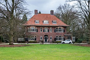
Villa Mariënhof
Building in North Brabant, Netherlands
Distance: Approx. 4162 meters
Latitude and longitude: 51.55813889,5.04777778
Villa Mariënhof is a historic mansion with a garden located along the Bredaseweg in the Dutch city Tilburg. It was built between 1916 and 1918 as the residence of the family of a factory owner, and it was designed by Johan Wilhelm Hanrath. In 1986, it was inherited by Staatsbosbeheer, who first used Villa Mariënhof as an office and later rented it.
Weather in this IP's area
broken clouds
21 Celsius
21 Celsius
20 Celsius
23 Celsius
1007 hPa
57 %
1007 hPa
1005 hPa
10000 meters
5.14 m/s
180 degree
75 %
07:04:17
20:11:08