45.82.16.54 - IP Lookup: Free IP Address Lookup, Postal Code Lookup, IP Location Lookup, IP ASN, Public IP
Country:
 Finland
Region:
City:
Location:
Time Zone:
Postal Code:
ISP:
ASN:
language:
User-Agent:
Proxy IP:
Blacklist:
IP information under different IP Channel
ip-api
Country
Region
City
ASN
Time Zone
ISP
Blacklist
Proxy
Latitude
Longitude
Postal
Route
db-ip
Country
Region
City
ASN
Time Zone
ISP
Blacklist
Proxy
Latitude
Longitude
Postal
Route
IPinfo
Country
Region
City
ASN
Time Zone
ISP
Blacklist
Proxy
Latitude
Longitude
Postal
Route
IP2Location
45.82.16.54Country
fiRegion
lappi
City
kolari
Time Zone
Europe/Helsinki
ISP
Language
User-Agent
Latitude
Longitude
Postal
ipdata
Country
Region
City
ASN
Time Zone
ISP
Blacklist
Proxy
Latitude
Longitude
Postal
Route
Popular places and events near this IP address

Kolari
Municipality in Lapland, Finland
Distance: Approx. 6 meters
Latitude and longitude: 67.33055556,23.77777778
Kolari is a municipality of Finland at the Swedish border, which follows the Torne River, the longest free-flowing river in Europe. It is located in the region of Lapland. The municipality has a population of 3,978 (31 December 2024) and covers an area of 2,617.87 square kilometres (1,010.77 sq mi) of which 59.15 km2 (22.84 sq mi) is water.
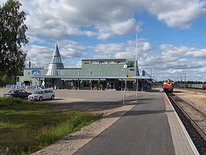
Kolari railway station
Railway station in Kolari, Finland
Distance: Approx. 3223 meters
Latitude and longitude: 67.34888889,23.83583333
Kolari railway station is located in the municipality of Kolari in the Lapland region of Finland, situated almost 3 km (1.9 mi) northeast of Kolari center, in Ylläsjokisuu. It is the northernmost railway station in Finland, located 800 km (500 mi) north of Helsinki Central railway station. The railway track extends 18 km (11 mi) further north to the Rautuvaara railway yard but this section is disused - the Rautuvaara iron ore mine closed in 1989.
Weather in this IP's area
light snow
-13 Celsius
-20 Celsius
-13 Celsius
-13 Celsius
1018 hPa
95 %
1018 hPa
994 hPa
134 meters
5.14 m/s
15.07 m/s
153 degree
100 %