Country:
 France
Region:
City:
Latitude and Longitude:
Time Zone:
Postal Code:
IP information under different IP Channel
ip-api
Country
Region
City
ASN
Time Zone
ISP
Blacklist
Proxy
Latitude
Longitude
Postal
Route
IPinfo
Country
Region
City
ASN
Time Zone
ISP
Blacklist
Proxy
Latitude
Longitude
Postal
Route
MaxMind
Country
Region
City
ASN
Time Zone
ISP
Blacklist
Proxy
Latitude
Longitude
Postal
Route
Luminati
Country
FRASN
Time Zone
Europe/Paris
ISP
Association Grenode
Latitude
Longitude
Postal
db-ip
Country
Region
City
ASN
Time Zone
ISP
Blacklist
Proxy
Latitude
Longitude
Postal
Route
ipdata
Country
Region
City
ASN
Time Zone
ISP
Blacklist
Proxy
Latitude
Longitude
Postal
Route
Popular places and events near this IP address

Aix-en-Diois
Part of Solaure-en-Diois in Auvergne-Rhône-Alpes, France
Distance: Approx. 4856 meters
Latitude and longitude: 44.7106,5.4019
Aix-en-Diois (French pronunciation: [ɛks ɑ̃ diwa]; Vivaro-Alpine: Ais de Diés) is a former commune in the Drôme department in southeastern France. On 1 January 2016, it was merged into the new commune Solaure-en-Diois.

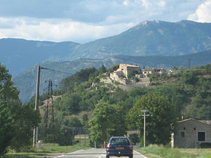
Die, Drôme
Subprefecture and commune in Auvergne-Rhône-Alpes, France
Distance: Approx. 562 meters
Latitude and longitude: 44.7536,5.3703
Die (French: [di] ; Vivaro-Alpine: Diá [djɔ]; Arpitan: Dia [dja]) is a commune, a former episcopal see, and a subprefecture of the Drôme department in southeastern France. The region around Die is known as the Diois [fr] (Vivaro-Alpine: Diés; Arpitan: Diês). Die is perhaps best known for its sparkling wine Clairette de Die.

Arrondissement of Die
Arrondissement in Auvergne-Rhône-Alpes, France
Distance: Approx. 641 meters
Latitude and longitude: 44.75416667,5.36944444
The arrondissement of Die is an arrondissement in the Drôme department in the Auvergne-Rhône-Alpes region of France. It has 113 communes. Its population is 67,156 (2016), and its area is 2,535.6 km2 (979.0 sq mi).
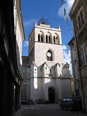
Die Cathedral
Distance: Approx. 398 meters
Latitude and longitude: 44.75222222,5.37111111
Die Cathedral (French: Cathédrale Notre-Dame de Die) is a Roman Catholic church located in Die, Drôme, France. The former cathedral is a national monument. Die Cathedral was previously the seat of the Bishop of Die.

Ancient Diocese of Die
Roman Catholic diocese in France (3rd c. - 1275, 1687 - 1801)
Distance: Approx. 214 meters
Latitude and longitude: 44.75,5.37
The former French Catholic diocese of Die existed from the fourth to the thirteenth century, and then again from 1678 to the French Revolution. It was suppressed by the Concordat of 1801, its territory being assigned to the diocese of Grenoble. The seat of the bishop was located in the Cathedral of the Assumption in Die.

Chamaloc
Commune in Auvergne-Rhône-Alpes, France
Distance: Approx. 5765 meters
Latitude and longitude: 44.7997,5.3847
Chamaloc (French pronunciation: [ʃamalɔk]; Occitan: Chamalòsc) is a commune of the Drôme department in southeastern France.

Laval-d'Aix
Commune in Auvergne-Rhône-Alpes, France
Distance: Approx. 6117 meters
Latitude and longitude: 44.7142,5.4322
Laval-d'Aix is a commune in the Drôme department in southeastern France.
Molières-Glandaz
Part of Solaure-en-Diois in Auvergne-Rhône-Alpes, France
Distance: Approx. 3285 meters
Latitude and longitude: 44.7269,5.4
Molières-Glandaz (Vivaro-Alpine: Molèiras de Glandàs) is a former commune in the Drôme department in southeastern France. On 1 January 2016, it was merged into the new commune Solaure-en-Diois.

Romeyer
Commune in Auvergne-Rhône-Alpes, France
Distance: Approx. 4595 meters
Latitude and longitude: 44.7803,5.4094
Romeyer (French pronunciation: [ʁɔmɛje]; Occitan: Romeièr) is a commune in the Drôme department in southeastern France.
Solaure-en-Diois
Commune in Auvergne-Rhône-Alpes, France
Distance: Approx. 4918 meters
Latitude and longitude: 44.71,5.402
Solaure-en-Diois (French pronunciation: [sɔlɔʁ ɑ̃ diwa]) is a commune in the Drôme department of southeastern France. The municipality was established on 1 January 2016 and consists of the former communes of Aix-en-Diois and Molières-Glandaz.
Canton of Le Diois
Distance: Approx. 214 meters
Latitude and longitude: 44.75,5.37
The canton of Le Diois is an administrative division of the Drôme department, southeastern France. It was created at the French canton reorganisation which came into effect in March 2015. Its seat is in Die.

Musée de Die
Archaeological museum in Die
Distance: Approx. 723 meters
Latitude and longitude: 44.7550103,5.36982
The Musée de Die et du Diois is an archaeological museum dedicated to the story of Die, France, the ancient Roman city Augusta Dea Vocontiorum.
Weather in this IP's area
scattered clouds
13 Celsius
13 Celsius
13 Celsius
14 Celsius
1013 hPa
93 %
1013 hPa
966 hPa
10000 meters
1.63 m/s
1.6 m/s
142 degree
32 %
07:57:55
18:48:57