Country:
 Slovakia
Region:
City:
Latitude and Longitude:
Time Zone:
Postal Code:
IP information under different IP Channel
ip-api
Country
Region
City
ASN
Time Zone
ISP
Blacklist
Proxy
Latitude
Longitude
Postal
Route
IPinfo
Country
Region
City
ASN
Time Zone
ISP
Blacklist
Proxy
Latitude
Longitude
Postal
Route
MaxMind
Country
Region
City
ASN
Time Zone
ISP
Blacklist
Proxy
Latitude
Longitude
Postal
Route
Luminati
Country
SKRegion
ta
City
piestany
ASN
Time Zone
Europe/Bratislava
ISP
Automation & Business, s.r.o.
Latitude
Longitude
Postal
db-ip
Country
Region
City
ASN
Time Zone
ISP
Blacklist
Proxy
Latitude
Longitude
Postal
Route
ipdata
Country
Region
City
ASN
Time Zone
ISP
Blacklist
Proxy
Latitude
Longitude
Postal
Route
Popular places and events near this IP address
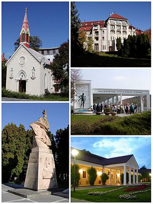
Piešťany
Town in Slovakia
Distance: Approx. 1187 meters
Latitude and longitude: 48.58416667,17.83361111
Piešťany (Slovak pronunciation: [ˈpɪeʂcani] ; German: Pistyan, Hungarian: Pöstyén, Polish: Pieszczany [pjɛˈʂtʂanɨ], Czech: Píšťany [ˈpiːʃcanɪ]) is a town in Slovakia. It is located in the western part of the country within the Trnava Region and is the seat of its own district. It is the biggest and best known spa town in Slovakia and has around 28,000 inhabitants.
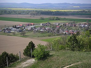
Ducové
Village in Slovakia
Distance: Approx. 4855 meters
Latitude and longitude: 48.62777778,17.86805556
Ducové (Hungarian: Ducó) is a municipality (village) situated in western Slovakia, near the spa town of Piešťany. It was part of the municipality Moravany nad Váhom from 1976 to 1992. The village lies under the Váh Inovec.

Piešťany District
District in Trnava Region, Slovakia
Distance: Approx. 754 meters
Latitude and longitude: 48.58916667,17.83416667
Piešťany District (okres Piešťany) is a district in the Trnava Region of western Slovakia, with the town of Piešťany being as its seat, cultural and economic center.
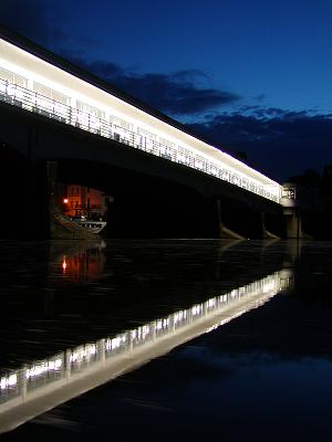
Kolonádový most (Piešťany)
Distance: Approx. 1170 meters
Latitude and longitude: 48.58805556,17.84
Kolonádový most (literally The Colonnade Bridge) is a bridge over the Váh river in Piešťany. It connects the town to the Spa Island. The bridge was designed by architect Emil Belluš in 1930–33, in Streamline Moderne, an international style of Art Deco architecture that emerged in the 1930s.

Banka, Piešťany District
Village in Slovakia
Distance: Approx. 2074 meters
Latitude and longitude: 48.58333333,17.85
Banka (Hungarian: Bánka) is a village and municipality in the Piešťany District in the Trnava Region of western Slovakia, near the Váh river.
Ratnovce
Municipality in Slovakia
Distance: Approx. 3474 meters
Latitude and longitude: 48.56666667,17.85
Ratnovce (Hungarian: Ratnóc) is a village and municipality in Piešťany District in the Trnava Region of western Slovakia.

Moravany nad Váhom
Village in Slovakia
Distance: Approx. 2915 meters
Latitude and longitude: 48.60277778,17.86388889
Moravany nad Váhom (Hungarian: Moraván) is a village and municipality in Piešťany District in the Trnava Region of western Slovakia.

Veľké Orvište
Municipality in Slovakia
Distance: Approx. 3216 meters
Latitude and longitude: 48.61666667,17.8
Veľké Orvište (Hungarian: Nagyőrvistye) is a village and municipality in Piešťany District in the Trnava Region of western Slovakia.

Patrícia Ice Arena 37
Distance: Approx. 1778 meters
Latitude and longitude: 48.57888889,17.81805556
Easton Arena (styled EASTON Arena, formerly Patrícia Ice Arena 37 and Zimný Štadión Piešťany) is an arena in Piešťany, Slovakia. It was built in 1986 and is primarily used for ice hockey and is the home arena of ŠHK 37 Piešťany. It also hosted matches for the 2002 IIHF World U18 Championships and is a perennial host of the Ivan Hlinka Memorial Tournament.
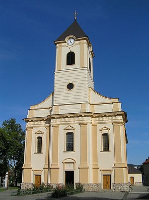
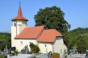
Roman Catholic Church in Piešťany
Distance: Approx. 1007 meters
Latitude and longitude: 48.6019,17.8328
The Roman Catholic Church in Piešťany, dedicated to St. Stephen, is in the old town of Piešťany, Slovakia and is a national cultural monument. The first mention of the Roman Catholic parish and church is from the year 1332.
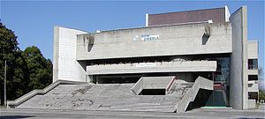
House of Arts Piešťany
Distance: Approx. 985 meters
Latitude and longitude: 48.59225556,17.83986667
House of Arts (Slovak: Dom Umenia) is cultural and social center situated at Embankment of Ivan Krasko in Piešťany. The House of Arts is a first Slovak theatre building for a special purpose after World War II that was not realized in Bratislava. It was realized in 1974-1979 (in use since 1980) according to project of architect Ferdinand Milučký.

Military History Museum Piešťany
Military museum in Piešťany, Slovakia
Distance: Approx. 1589 meters
Latitude and longitude: 48.608,17.8289
Military History Museum Piešťany (Slovak: Vojenské historické múzeum Piešťany, abbreviation VHM Piešťany) is a military museum in Piešťany in western Slovakia. It is located in Piešťany Airport in buildings of former military base. It was opened in 2004.
Weather in this IP's area
scattered clouds
7 Celsius
5 Celsius
6 Celsius
9 Celsius
1022 hPa
57 %
1022 hPa
1002 hPa
10000 meters
2.61 m/s
5.77 m/s
115 degree
38 %
07:14:56
17:51:57