Country:
 Canada
Region:
City:
Latitude and Longitude:
Time Zone:
Postal Code:
IP information under different IP Channel
ip-api
Country
Region
City
ASN
Time Zone
ISP
Blacklist
Proxy
Latitude
Longitude
Postal
Route
IPinfo
Country
Region
City
ASN
Time Zone
ISP
Blacklist
Proxy
Latitude
Longitude
Postal
Route
MaxMind
Country
Region
City
ASN
Time Zone
ISP
Blacklist
Proxy
Latitude
Longitude
Postal
Route
Luminati
Country
CARegion
on
City
toronto
ASN
Time Zone
America/Toronto
ISP
M247 Europe SRL
Latitude
Longitude
Postal
db-ip
Country
Region
City
ASN
Time Zone
ISP
Blacklist
Proxy
Latitude
Longitude
Postal
Route
ipdata
Country
Region
City
ASN
Time Zone
ISP
Blacklist
Proxy
Latitude
Longitude
Postal
Route
Popular places and events near this IP address
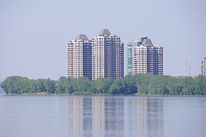
Nuns' Island
Neighbourhood in Montreal, Quebec, Canada
Distance: Approx. 629 meters
Latitude and longitude: 45.46111111,-73.54333333
Nuns' Island (officially Île-des-Sœurs; French pronunciation: [il de sœʁ]) is an island located in the Saint Lawrence River that forms a part of the city of Montreal, Quebec. It is part of the borough of Verdun.

Verdun Auditorium
Arena in Montreal, Quebec, Canada
Distance: Approx. 1664 meters
Latitude and longitude: 45.462448,-73.561878
The Verdun Auditorium (French: Auditorium de Verdun) is an arena located in the borough of Verdun, in Montreal, Quebec, Canada. The building was constructed in 1938 and holds 4,114 seats. The largest arena in the west end of Montreal, the complex is also home to Arena Denis Savard, a small minor-hockey rink, attached to its side.

Verdun (provincial electoral district)
Provincial electoral district in Quebec, Canada
Distance: Approx. 1627 meters
Latitude and longitude: 45.46,-73.56
Verdun is a provincial electoral district in the Montreal region of Quebec, Canada that elects members to the National Assembly of Quebec. Its territory corresponds exactly to the borough of Verdun of the city of Montreal. It was created for the 1966 election from Montréal-Verdun electoral district.

Victoria STOLport
Airport in Montreal, Quebec
Distance: Approx. 1833 meters
Latitude and longitude: 45.48305556,-73.54055556
Victoria STOLport (IATA: YMY, ICAO: CYMY) was a short take-off and landing aerodrome near downtown Montreal during the mid-1970s. The STOLport had been constructed on the former parking lot for Expo 67. The airport operated a two-year STOL demonstration service, with the participation of the Ministry of Transportation, the Canadian Air Transport Administration and other Federal Agencies in order to obtain and evaluate the data on passengers and economics of the STOL service.
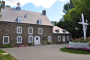
Maison Saint-Gabriel
Farm museum in Quebec, Canada
Distance: Approx. 1540 meters
Latitude and longitude: 45.4759,-73.556
The Maison Saint-Gabriel Museum is located in Montreal, Quebec and is dedicated to preserving the history, heritage and artifacts of the settlers of New France in the mid 17th century. The museum consists of a small farm, which has been administered for more than 300 years by the Sisters of the Congregation of Notre Dame of Montreal, founded by Marguerite Bourgeoys in Montreal in 1658. The site was designated a National Historic Site of Canada in 2007.
Parc d'entreprises de la Pointe-Saint-Charles
Neighbourhood in Montreal, Quebec, Canada
Distance: Approx. 1710 meters
Latitude and longitude: 45.481944,-73.540278
The Parc d'entreprises de la Pointe-Saint-Charles, formerly known as the Montreal Technoparc and Adaport Victoria, is an industrial park and former industrial dump in the Pointe-Saint-Charles neighbourhood of Montreal, between the Champlain and Victoria bridges.
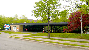
Nuns' Island gas station
Service station in Montreal
Distance: Approx. 765 meters
Latitude and longitude: 45.4601,-73.5446
The Nuns' Island gas station was a modernist-style filling station in Montreal built in 1969 from a project of Ludwig Mies van der Rohe. Closed for several years, it was later converted to a community centre. It was the first gas station on the island, commissioned by Imperial Oil.

Wellington Street (Montreal)
Thoroughfare in Montreal, Canada
Distance: Approx. 1802 meters
Latitude and longitude: 45.476,-73.5602
Wellington Street (officially in French: Rue Wellington) is a north–south thoroughfare located in Montreal, Quebec, Canada. It starts at LaSalle Boulevard in the borough of Verdun, passes through Pointe-Saint-Charles and Griffintown in the borough of Le Sud-Ouest, and terminates at McGill Street in Old Montreal in the borough of Ville-Marie. Wellington Street spans 5.7 km (3.5 mi) in length.

Hôpital de Verdun
Hospital in Montreal, Quebec, Canada
Distance: Approx. 1782 meters
Latitude and longitude: 45.463889,-73.563889
Hôpital de Verdun (English: Verdun General Hospital) is a rural general hospital in Montreal, Quebec, Canada. It is located at 4000 LaSalle Boulevard in the borough of Verdun.

Île-des-Soeurs station
Railway station in Quebec, Canada
Distance: Approx. 521 meters
Latitude and longitude: 45.4705,-73.5377
Île-des-Soeurs station is a Réseau express métropolitain (REM) station on Nuns' Island in Montreal's borough of Verdun. It is operated by CDPQ Infra and serves as a station on the South Shore branch of the REM. It is located between the headquarters of Bell Canada (to the north) and the Place du Commerce shopping centre (to the south) atop Highway 10/A 15. It opened on 31 July 2023.

Marguerite Bourgeoys Park
Urban park in Montreal, Canada
Distance: Approx. 1654 meters
Latitude and longitude: 45.47499444,-73.55887778
Marguerite Bourgeoys Park (French: Parc Marguerite-Bourgeoys) is a park in the Pointe-Saint-Charles neighbourhood of the Le Sud-Ouest borough of Montreal, Quebec, Canada. It is bordered by du Parc Marguerite-Bourgeoys Street to the north and east, des Filles du Roy Street to the south, and Wellington Street to the west. The park was created in 1910.
Bâtiment 7 (Montreal)
Distance: Approx. 1805 meters
Latitude and longitude: 45.4809,-73.5523
Bâtiment 7 is a space of 90,000 square foot in Montreal in the Quebec province in Canada, converted into a shared community space, in the Pointe Saint-Charles suburb of Montreal. It is located on the previous plot of real estate owned by the train company Canadian National Railway (CN). In 2003, a group of persons living in Pointe Saint-Charles planted a symbolic flag on the terrain that hosted old CN workshops.
Weather in this IP's area
clear sky
12 Celsius
11 Celsius
10 Celsius
13 Celsius
1032 hPa
68 %
1032 hPa
1031 hPa
10000 meters
3.09 m/s
210 degree
07:14:49
18:03:17