Country:
 Poland
Region:
City:
Latitude and Longitude:
Time Zone:
Postal Code:
IP information under different IP Channel
ip-api
Country
Region
City
ASN
Time Zone
ISP
Blacklist
Proxy
Latitude
Longitude
Postal
Route
IPinfo
Country
Region
City
ASN
Time Zone
ISP
Blacklist
Proxy
Latitude
Longitude
Postal
Route
MaxMind
Country
Region
City
ASN
Time Zone
ISP
Blacklist
Proxy
Latitude
Longitude
Postal
Route
Luminati
Country
PLRegion
12
City
krakow
ASN
Time Zone
Europe/Warsaw
ISP
ITH sp. z o.o.
Latitude
Longitude
Postal
db-ip
Country
Region
City
ASN
Time Zone
ISP
Blacklist
Proxy
Latitude
Longitude
Postal
Route
ipdata
Country
Region
City
ASN
Time Zone
ISP
Blacklist
Proxy
Latitude
Longitude
Postal
Route
Popular places and events near this IP address

Służewiec Przemysłowy
Neighbourhood in Warsaw, Masovian Voivodeship, Poland
Distance: Approx. 1248 meters
Latitude and longitude: 52.18055556,20.99972222
Służewiec Przemysłowy, originally known as the Industrial and Storage District of Służewiec, is a neighbourhood of the city of Warsaw, Poland, located within the district of Mokotów and Ursynów, within the City Information System areas of Służewiec, western Ksawerów, and northern Wyczółki. It mostly consists of office buildings.

Wierzbno, Warsaw
Neighbourhood in Warsaw, Poland
Distance: Approx. 1183 meters
Latitude and longitude: 52.19444444,21.01444444
Wierzbno is a neighbourhood, and an area of the City Information System, in the city of Warsaw, Poland, located within the district of Mokotów. It is a residential area, with most of its eastern area consisting of villas and tenements, and its western area, and a portion of its eastern area, consisting of multifamily residential large panel system-buildings. Wierzbno was established as a small settlement in the 1770s, by Józef Jakubowski, a brigadier in the French Army.

Foreign Intelligence Agency
Polish intelligence agency
Distance: Approx. 872 meters
Latitude and longitude: 52.19916389,20.99382222
The Foreign Intelligence Agency (Polish: Agencja Wywiadu (Polish pronunciation: [aˈɡɛnt͡sja vɨˈvʲadu]; or AW) is a Polish intelligence agency tasked with the gathering of public and secret information abroad for the Republic of Poland. It was created in 2002 from the reform and split of Urząd Ochrony Państwa, which was split into Agencja Wywiadu (AW) and Agencja Bezpieczeństwa Wewnętrznego (ABW). Current Head of the Foreign Intelligence Agency is Colonel Bartosz Jarmuszkiewicz.

Wierzbno metro station
Warsaw metro station
Distance: Approx. 1313 meters
Latitude and longitude: 52.18972222,21.01666667
Metro Wierzbno is a station on Line M1 of the Warsaw Metro, located in the Wierzbno neighbourhood, from which it derives its name. The station is in the Mokotów district of Warsaw. The station was opened on 7 April 1995 as part of the inaugural stretch of the Warsaw Metro, between Kabaty and Politechnika.

Racławicka metro station
Warsaw metro station
Distance: Approx. 1255 meters
Latitude and longitude: 52.19861111,21.01222222
Metro Racławicka is a station on Line M1 of the Warsaw Metro. It is located in the Mokotów district of Warsaw, at the junction of ulica Racławicka (Racławicka Street) and Aleja Niepodległości (Independence Avenue). The station was opened on 7 April 1995 as part of the inaugural stretch of the Warsaw Metro, between Kabaty and Politechnika.

Westfield Mokotów
Shopping centre in Warsaw, Poland
Distance: Approx. 1434 meters
Latitude and longitude: 52.17944444,21.00416667
Westfield Mokotów, previously known as Galeria Mokotów, is a shopping centre in Warsaw, Poland, in the district of Mokotów. It is located at the 12 Wołoska Street. The building was opened in 2000.
Wyględów
Neighbourhood in Warsaw, Poland
Distance: Approx. 637 meters
Latitude and longitude: 52.19666667,20.99305556
Wyględów is a neighbourhood, and the City Information System area, located in Warsaw, Poland, within the district of Mokotów. The oldest known records of localities in the area of modern neighbourhood come from 16th century, referring to the settlement of Wyględowo-Kościesze. It was originally formed from two settlements, Wyględowo and Kościesze, with the latter being originally part of the nearby Rakowiec.
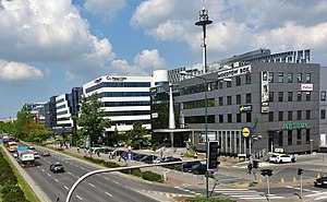
Służewiec
Neighbourhood of Warsaw, Poland
Distance: Approx. 1358 meters
Latitude and longitude: 52.17972222,20.99388889
Służewiec is a neighbourhood, and an area of the City Information System, in the city of Warsaw, Poland, located within the district of Mokotów. Most of the neighbourhood consists of office buildings, which form one of the biggest complexes of office buildings in Poland, and one of the most important office centres in the city. It contains many headquarters of branches of many domestic and multinational corporations.
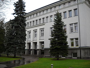
Faculty of Management of Warsaw University of Technology
Distance: Approx. 1306 meters
Latitude and longitude: 52.203056,21.0025
The Faculty of Management at the Warsaw University of Technology (pl.: Wydział Zarządzania Politechniki Warszawskiej , WZ) is a business school in Warsaw. Its facilities are located on the southern side of the Warsaw University of Technology campus on ul. Narbutta 85.
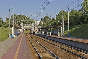
Warszawa Żwirki i Wigury railway station
Railway station in Warsaw, Poland
Distance: Approx. 1142 meters
Latitude and longitude: 52.19305556,20.98111111
Warszawa Żwirki i Wigury railway station is a railway station in the Ochota district of Warsaw, Poland. It is served by Koleje Mazowieckie, who run services from Warszawa Wschodnia to Góra Kalwaria or Skarżysko-Kamienna.

Warszawa Służewiec railway station
Railway station in Warsaw, Poland
Distance: Approx. 1468 meters
Latitude and longitude: 52.18027778,20.98694444
Warszawa Służewiec is a railway stop in the city of Warsaw, Poland, on Marynarska Street, operated by the Polish State Railways. It is located at the railway line no. 8, which connects Warszawa Zachodnia (Warsaw West) and Kraków Główny (Kraków Main) railway stations.
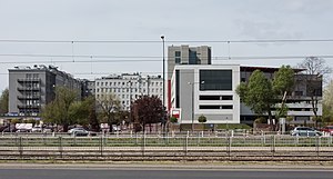
Mordor, Warsaw
Informal name for an area of Warsaw, Poland
Distance: Approx. 1248 meters
Latitude and longitude: 52.18055556,20.99972222
Mordor, also known as Mordor on Domaniewska Street, is an informal name for the area, mostly composed of office buildings, in the city of Warsaw, Poland, located within the neighbourhoods of Służewiec (Służewiec Przemysłowy) and western Ksawerów in the district of Mokotów. It is located in the area around Cybernetyki, Domaniewska, Marynarska, and Wołoska Streets. The area is mostly composed of office buildings, including the headquarters of branches of many multinational corporations.
Weather in this IP's area
clear sky
14 Celsius
13 Celsius
13 Celsius
16 Celsius
1029 hPa
61 %
1029 hPa
1016 hPa
10000 meters
3.09 m/s
90 degree
06:19:06
18:39:43