Country:
 Greece
Region:
City:
Latitude and Longitude:
Time Zone:
Postal Code:
IP information under different IP Channel
ip-api
Country
Region
City
ASN
Time Zone
ISP
Blacklist
Proxy
Latitude
Longitude
Postal
Route
IPinfo
Country
Region
City
ASN
Time Zone
ISP
Blacklist
Proxy
Latitude
Longitude
Postal
Route
MaxMind
Country
Region
City
ASN
Time Zone
ISP
Blacklist
Proxy
Latitude
Longitude
Postal
Route
Luminati
Country
GRRegion
b
City
thessaloniki
ASN
Time Zone
Europe/Athens
ISP
Lancom Ltd.
Latitude
Longitude
Postal
db-ip
Country
Region
City
ASN
Time Zone
ISP
Blacklist
Proxy
Latitude
Longitude
Postal
Route
ipdata
Country
Region
City
ASN
Time Zone
ISP
Blacklist
Proxy
Latitude
Longitude
Postal
Route
Popular places and events near this IP address
Thessaloniki
City in Macedonia, Greece
Distance: Approx. 404 meters
Latitude and longitude: 40.64027778,22.93555556
Thessaloniki (; Greek: Θεσσαλονίκη [θesaloˈnici] ), also known as Thessalonica (English: ), Saloniki, Salonika, or Salonica (), is the second-largest city in Greece, with slightly over one million inhabitants in its metropolitan area, and the capital of the geographic region of Macedonia, the administrative region of Central Macedonia and the Decentralized Administration of Macedonia and Thrace. It is also known in Greek as "η Συμπρωτεύουσα" (i Symprotévousa), literally "the co-capital", a reference to its historical status as the Συμβασιλεύουσα (Symvasilévousa) or "co-reigning" city of the Byzantine Empire alongside Constantinople. Thessaloniki is located on the Thermaic Gulf, at the northwest corner of the Aegean Sea.

Apostolic Vicariate of Thessaloniki
Latin Catholic missionary jurisdiction in Greece
Distance: Approx. 756 meters
Latitude and longitude: 40.6374,22.9384
The Apostolic Vicariate of Thessaloniki (Latin: Vicariatus Apostolicus Thessalonicensis) is a Latin Church ecclesiastical territory or apostolic vicariate of the Catholic Church in northern continental Greece. It is exempt to the Holy See and is not part of any ecclesiastical province, and remains vacant under apostolic administrators since its only proper apostolic vicar, Alessandro Guidati, was promoted Archbishop of Naxos, Andros, Tinos and Mykonos in 1929. Its cathedra is within the Cathedral of the Immaculate Conception, in Thessaloniki.

Monastir Synagogue (Thessaloniki)
Former Orthodox synagogue in Thessaloniki, Greece
Distance: Approx. 696 meters
Latitude and longitude: 40.6397,22.9419
The Monastir Synagogue (Hebrew: קהל קדוש מונאסטירליס, Judaeo-Spanish "Kal de los Monastirlis") is a former Orthodox Jewish congregation and synagogue of the once vibrant Jewish community in Thessaloniki, Greece.

Thessaloniki–Alexandroupolis railway
Distance: Approx. 543 meters
Latitude and longitude: 40.6444,22.9294
The Thessaloniki–Alexandroupolis railway is an about 440 km long railway in northern Greece connecting the Central Macedonian city of Thessaloniki with Alexandroupolis in Eastern Macedonia and Thrace, via Serres. There is a connection towards Sofia at the Strymonas station. This railway was built in 1896 by The Compagnie du Chemin de Fer Ottoman Jonction Salonique-Constantinople (JSC).

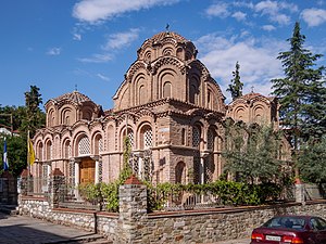
Church of the Holy Apostles (Thessaloniki)
UNESCO World Heritage Site in Macedonia, Greece
Distance: Approx. 189 meters
Latitude and longitude: 40.64283889,22.93754722
The Church of the Holy Apostles (Greek: Ἅγιοι Ἀπόστολοι) is a 14th-century Byzantine church in the northern Greek city of Thessaloniki. Because of its outstanding Byzantine mosaics and architecture, and its testimony to the importance of Thessaloniki in early and medieval Christianity, the church is inscribed on the UNESCO World Heritage List along with other Paleochristian and Byzantine monuments of Thessaloniki.

Thessaloniki railway station
Railway station in Thessaloniki, Greece
Distance: Approx. 540 meters
Latitude and longitude: 40.64444444,22.92944444
The Thessaloniki railway station, or Thessaloniki railway station (Greek: Νέος Σιδηροδρομικός Σταθμός "ΝΕ.ΣΙ.Σ.", Θεσσαλονίκης, Neos Sidirodromikos Stathmos "NE.SI.S.", Thessalonikis) is the main central passenger railway station and terminal of Thessaloniki, Greece's second-largest city. It is located in the central quarter of Xirokrini on Monastiriou Street and was inaugurated on 12 June 1961, the passenger station replaced the older and much smaller passenger station which now handles the city's cargo rail, hence the "new" sometimes used in the name. As of 2022, long-distance trains from Thessaloniki railway station are run by Hellenic Train to Athens, Alexandroupoli, Larissa, and Florina; other long-distance operators include.

Thessaloniki–Bitola railway
Balkan railway
Distance: Approx. 543 meters
Latitude and longitude: 40.6444,22.9294
The railway from Thessaloniki to Bitola is a 219 kilometres (136 mi) long railway line, that connects the port city Thessaloniki in Greece with Bitola in the Republic of North Macedonia, via Veroia, Edessa, Amyntaio and Florina. The line was opened in 1894 under the name "Société du Chemin de Fer ottoman Salonique-Monastir", when the area was part of the Ottoman Empire. The section between the international border and Bitola is not used anymore, and as of 2013 passenger services are restricted to the section between Thessaloniki and Florina.
Church of Saint Catherine, Thessaloniki
UNESCO World Heritage Site in Macedonia, Greece
Distance: Approx. 723 meters
Latitude and longitude: 40.64319444,22.94430556
The Church of Saint Catherine (Greek: Αγία Αικατερίνη) is a late Byzantine church in the northwestern corner of the Ano Poli, Thessaloniki, Greece.
Immaculate Conception Cathedral, Thessaloniki
Church in Thessaloniki, Greece
Distance: Approx. 775 meters
Latitude and longitude: 40.6372,22.9383
The Immaculate Conception Cathedral (Greek: Καθεδρικός Ναός της Αμιάντου Συλλήψεως της Θεοτόκου) is a Roman Catholic church located on Frangon street in the city of Thessaloniki, in northern Greece. The church follows the Roman or Latin rite and functions as the seat of the Apostolic Vicariate of Thessaloniki (Vicariatus Apostolicus Thessalonicensis or Αποστολικό Βικαριάτο Θεσσαλονίκης).
Neos Sidirodromikos Stathmos metro station
Metro station in Thessaloniki, Greece
Distance: Approx. 561 meters
Latitude and longitude: 40.64361111,22.92916667
Neos Sidirodromikos Stathmos (Greek: Νέος Σιδηροδρομικός Σταθμός, literally new railway station, abbreviated on maps as N. Sid. Stathmos) is an under-construction metro station at the Thessaloniki railway station, serving Thessaloniki Metro's Line 1 and Line 2. It will serve as the western terminus of both lines and is expected to enter service in 2023.
Dimokratias station
Metro station in Thessaloniki, Greece
Distance: Approx. 340 meters
Latitude and longitude: 40.64111111,22.93416667
Dimokratias (Greek: Δημοκρατίας, literally Democracy [Square]) is an under-construction metro station serving Thessaloniki Metro's Line 1 and Line 2. It is expected to enter service in 2023. Construction of this station has been held back by major archaeological finds, and it is designated as a high-importance archaeological site by Attiko Metro, the company overseeing its construction.

Strymon-Kulata railway
Railway crossing through Bulgaria and Greece
Distance: Approx. 543 meters
Latitude and longitude: 40.6444,22.9294
The Strymon-Kulata railway is a 17.5-kilometre-long (10.9 mi) railway line that connects the village of Strymon in Greece with Kulata in Bulgaria. The line unites three villages on opposite sides of the border, Strymon and Promachonas in Serres, Greece, and Kulata in Blagoevgrad, Bulgaria, and is entrance/exit to the Greek rail network from Bulgaria.
Weather in this IP's area
few clouds
29 Celsius
31 Celsius
28 Celsius
30 Celsius
1015 hPa
58 %
1015 hPa
1011 hPa
10000 meters
5.14 m/s
190 degree
20 %
07:02:28
19:49:37