Country:
 USA
USARegion:
City:
Latitude and Longitude:
Time Zone:
Postal Code:
IP information under different IP Channel
ip-api
Country
Region
City
ASN
Time Zone
ISP
Blacklist
Proxy
Latitude
Longitude
Postal
Route
IPinfo
Country
Region
City
ASN
Time Zone
ISP
Blacklist
Proxy
Latitude
Longitude
Postal
Route
MaxMind
Country
Region
City
ASN
Time Zone
ISP
Blacklist
Proxy
Latitude
Longitude
Postal
Route
Luminati
Country
USRegion
mn
City
minneapolis
ASN
Time Zone
America/Chicago
ISP
G-Core Labs S.A.
Latitude
Longitude
Postal
db-ip
Country
Region
City
ASN
Time Zone
ISP
Blacklist
Proxy
Latitude
Longitude
Postal
Route
ipdata
Country
Region
City
ASN
Time Zone
ISP
Blacklist
Proxy
Latitude
Longitude
Postal
Route
Popular places and events near this IP address
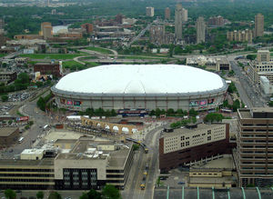
Hubert H. Humphrey Metrodome
Former stadium in Minneapolis, Minnesota
Distance: Approx. 287 meters
Latitude and longitude: 44.97388889,-93.25805556
The Hubert H. Humphrey Metrodome (commonly called the Metrodome) was a domed sports stadium located in downtown Minneapolis, Minnesota. It opened in 1982 as a replacement for Metropolitan Stadium, the former home of the National Football League's (NFL) Minnesota Vikings and Major League Baseball's (MLB) Minnesota Twins, and Memorial Stadium, the former home of the Minnesota Golden Gophers football team. The Metrodome was the home of the Vikings from 1982 to 2013, the Twins from 1982 to 2009, the National Basketball Association's (NBA) Minnesota Timberwolves in their 1989–90 inaugural season, the Golden Gophers football team from 1982 to 2008, and the occasional home of the Golden Gophers baseball team from 1985 to 2010 and their full-time home in 2012.
Minneapolis Aquatennial
Annual outdoor event in Minneapolis, USA
Distance: Approx. 405 meters
Latitude and longitude: 44.9773,-93.2654
The Minneapolis Aquatennial is an annual outdoor event held in the U.S. city of Minneapolis, Minnesota, during the third full week of July. Originating in 1940, overshadowing the teamster picnics "to take the minds of Minneapolis citizens off past troubles and focus all minds throughout the state on some pleasant event", the Minneapolis Aquatennial celebrates the city's famous lakes, rivers, and streams. Advertised as The Best Days of Summer the festivities initially included some 200 events over 10 days (hence Aqua-ten-ial), at one point or another including the Aqua Follies, the Xcel Energy Sand Castle Competition, the Tom Thumb Milk Carton Boat Races, the Ultimate Wireless Co-ed Beach Volleyball Tournament, a sailing regatta, a tennis invitational, the Life Time Fitness Triathlon, many parades, among them the Minnegasco Torchlight Parade, the Master of International Management presents Shakespeare in the Park, Subway Block Party and the final Target Fireworks, one of the largest in the country, much larger than the city's Fourth of July celebration.

Minneapolis City Hall
United States historic place
Distance: Approx. 405 meters
Latitude and longitude: 44.9773,-93.2654
Minneapolis City Hall and Hennepin County Courthouse (also known as the Municipal Building), designed by Long and Kees in 1888, is the main building used by the city government of Minneapolis, as well as by Hennepin County, in the U.S. state of Minnesota. The structure has served as mainly local government offices since it was built, and today the building is 60 percent occupied by the city and 40 percent occupied by the County. The building is jointly owned by the city and county and managed by the Municipal Building Commission.
Thrivent
Member-owned provider of insurance and other financial services
Distance: Approx. 365 meters
Latitude and longitude: 44.975007,-93.265831
Thrivent Financial for Lutherans (marketing name Thrivent) ( THRYVE-int), is an American Fortune 500 not-for-profit financial services organization headquartered in Minneapolis, Minnesota, and Appleton, Wisconsin, and founded by Lutherans. As a member-owned fraternal benefit society, it operates under a chapter system, serving nearly 2.3 million members. Operating through its local chapters nationwide, Thrivent and its subsidiaries offer financial products and services including life insurance, annuities, mutual funds, disability income insurance, credit union products, money management, brokerage services, and retirement planning.

Government Plaza station
Light rail station in Minneapolis, Minnesota
Distance: Approx. 404 meters
Latitude and longitude: 44.9768,-93.2658
Government Plaza station is a Metro light rail station on the Blue Line and Green Line in Minneapolis, Minnesota. The station is located on 5th Street South, between 3rd and 4th Avenues South in downtown Minneapolis. This station opened on June 26, 2004, with initial light rail service in the Twin Cities.

U.S. Bank Stadium station
A Minneapolis, Minnesota light rail station, named for the neighboring U.S. Bank Stadium.
Distance: Approx. 97 meters
Latitude and longitude: 44.975,-93.26
U.S. Bank Stadium station (formerly Downtown East/Metrodome (2004–13) and Downtown East (2014–16)) is a light rail station on the Metro Blue Line and Green Line in Minneapolis, Minnesota. The station is located next to U.S. Bank Stadium, where the Hubert H. Humphrey Metrodome plaza used to be at the east end of downtown Minneapolis. It is a side-platform station.

Hennepin County Medical Center
Hospital in Minnesota, United States
Distance: Approx. 306 meters
Latitude and longitude: 44.9725,-93.26194444
Hennepin County Medical Center (HCMC) is a Level I adult and pediatric trauma center and safety net hospital in Minneapolis, Minnesota, the county seat of Hennepin County. The primary 484-bed facility is on six city blocks across the street from U.S. Bank Stadium, with neighborhood clinics in the Minneapolis Whittier and East Lake neighborhoods, and the suburban communities of Brooklyn Center, Brooklyn Park, Golden Valley, St. Anthony and Richfield.

Minneapolis Armory
United States historic place
Distance: Approx. 164 meters
Latitude and longitude: 44.97509167,-93.26327778
The Minneapolis Armory is a historic event center and former National Guard armory located in downtown Minneapolis, Minnesota, United States. Built by the Public Works Administration in 1936, the building was occupied by several Army and Naval Militia units of the Minnesota National Guard from its opening until 1985. The building is listed on the National Register of Historic Places.
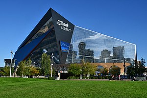
U.S. Bank Stadium
Multi-purpose stadium in Minneapolis, Minnesota, U.S.
Distance: Approx. 285 meters
Latitude and longitude: 44.974,-93.258
U.S. Bank Stadium is an enclosed stadium located in downtown Minneapolis, Minnesota. Built on the former site of the Hubert H. Humphrey Metrodome, the indoor stadium opened in 2016 and is the home of the Minnesota Vikings of the National Football League (NFL); it also hosts early season college baseball games of the University of Minnesota Golden Gophers. The Vikings played at the Metrodome from 1982 until its closure in 2013; during construction, the Vikings played two seasons (2014, 2015) at the open-air Huntington Bank Stadium on the campus of the University of Minnesota.

Advance Thresher/Emerson-Newton Implement Company
United States historic place
Distance: Approx. 255 meters
Latitude and longitude: 44.97680556,-93.25888889
The Advance Thresher/Emerson-Newton Implement Company buildings in Minneapolis, Minnesota, United States, are a pair of buildings designed by Kees and Colburn. The two buildings are united under a common cornice and appear to be a single structure. However, the two buildings were actually built four years apart.

Pittsburgh Plate Glass Company Building
United States historic place
Distance: Approx. 264 meters
Latitude and longitude: 44.97722222,-93.25944444
The Pittsburgh Plate Glass Company Building, also known as the Northern Implement Company and the American Trio Building, is a warehouse building in downtown Minneapolis, Minnesota. PPG Industries of Pittsburgh constructed the structure.

Philly Special
Notable American football play in Super Bowl LII
Distance: Approx. 373 meters
Latitude and longitude: 44.97334,-93.25726
The Philly Special, also known as Philly Philly, was an American football trick play between Philadelphia Eagles players Corey Clement, Trey Burton, and Nick Foles on fourth-down-and-goal toward the end of the second quarter of Super Bowl LII on February 4, 2018 at U.S. Bank Stadium in Minneapolis. On the play, quarterback Nick Foles moved up to behind his offensive line and Jason Kelce snapped the ball directly to running back Corey Clement. Clement went on to pitch the ball to Trey Burton, who passed the ball to a wide open Foles to score a touchdown.
Weather in this IP's area
clear sky
13 Celsius
13 Celsius
11 Celsius
15 Celsius
1020 hPa
83 %
1020 hPa
990 hPa
10000 meters
1.54 m/s
190 degree
06:42:59
19:39:09