Country:
Region:
City:
Latitude and Longitude:
Time Zone:
Postal Code:
IP information under different IP Channel
ip-api
Country
Region
City
ASN
Time Zone
ISP
Blacklist
Proxy
Latitude
Longitude
Postal
Route
Luminati
Country
ASN
Time Zone
America/Sao_Paulo
ISP
LINKABR TELECOM SPE LTDA
Latitude
Longitude
Postal
IPinfo
Country
Region
City
ASN
Time Zone
ISP
Blacklist
Proxy
Latitude
Longitude
Postal
Route
db-ip
Country
Region
City
ASN
Time Zone
ISP
Blacklist
Proxy
Latitude
Longitude
Postal
Route
ipdata
Country
Region
City
ASN
Time Zone
ISP
Blacklist
Proxy
Latitude
Longitude
Postal
Route
Popular places and events near this IP address

Feira de Santana
City in Bahia State, Brazil
Distance: Approx. 1170 meters
Latitude and longitude: -12.25,-38.95
Feira de Santana (Portuguese pronunciation: [ˈfejɾɐ d(ʒi) sɐ̃ˈtɐ̃nɐ]; Portuguese for "Saint Anne's Fair") is a city in Bahia, Brazil. It is the second-most populous city in the state, with a population of 616,272 according to IBGE's census in 2022. It is located 100 km northwest of Salvador, Bahia's capital city.

Estádio Joia da Princesa
Football stadium in Feira de Santana, municipality of the brazilian state of Bahia
Distance: Approx. 1668 meters
Latitude and longitude: -12.24458333,-38.97235
Estádio Municipal Alberto Oliveira, usually known as Estádio Joia da Princesa, is a multi-use stadium in Feira de Santana, Brazil. It is currently used mostly for football matches. The stadium holds 16,274.
Roman Catholic Archdiocese of Feira de Santana
Catholic ecclesiastical territory
Distance: Approx. 1110 meters
Latitude and longitude: -12.2594,-38.9684
The Roman Catholic Archdiocese of Feira de Santana (Latin: Archidioecesis Fori Sancti Annae) is an archdiocese located in the city of Feira de Santana in Brazil.

State University of Feira de Santana
Distance: Approx. 6286 meters
Latitude and longitude: -12.1975,-38.96666667
The State University of Feira de Santana (Portuguese: Universidade Estadual de Feira de Santana, UEFS) is a public institution of higher education in Brazil, based in the city of Feira de Santana, Bahia. Until the 1990s, it was also the only university in this city. Currently, the university has 27 graduate courses, offering 765 places by year for the third degree, with an average of 17.85 candidates per seat.
Feira de Santana Airport
Airport
Distance: Approx. 8307 meters
Latitude and longitude: -12.20055556,-38.90638889
Gov. João Durval Carneiro Airport (IATA: FEC, ICAO: SDIY) formerly SNJD, is the airport serving Feira de Santana, Brazil. It is named after a former Governor of the state of Bahia, born in 1929.
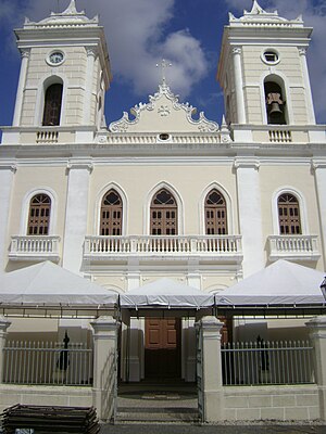
St. Ann Cathedral, Feira de Santana
Church in Feira de Santana, Brazil
Distance: Approx. 1122 meters
Latitude and longitude: -12.2595641,-38.96841548
The St. Ann Cathedral (Portuguese: Catedral Metropolitana de Sant'Ana), also known as the Feira de Santana Cathedral, is a Catholic cathedral in Feira de Santana, Bahia, Brazil. The cathedral is dedicated to Saint Anne and follows the Roman or Latin rite.
TV Subaé
Television station in Bahia, Brazil
Distance: Approx. 917 meters
Latitude and longitude: -12.2605,-38.9555
TV Subaé (channel 10) is a television station licensed to Feira de Santana, Bahia, Brazil affiliated with TV Globo. Owned by Grupo Modesto Cerqueira and Rede Bahia, TV Subaé is part of Rede Bahia de Televisão, a statewide television network composed of another five TV stations. TV Subaé's studios and transmitter are located on Presidente Dutra Avenue, in the center of Feira de Santana.
Weather in this IP's area
overcast clouds
30 Celsius
30 Celsius
30 Celsius
30 Celsius
1010 hPa
42 %
1010 hPa
983 hPa
10000 meters
4.74 m/s
5.71 m/s
139 degree
93 %
05:01:19
17:37:48

