45.59.159.95 - IP Lookup: Free IP Address Lookup, Postal Code Lookup, IP Location Lookup, IP ASN, Public IP
Country:
Region:
City:
Location:
Time Zone:
Postal Code:
ISP:
ASN:
language:
User-Agent:
Proxy IP:
Blacklist:
IP information under different IP Channel
ip-api
Country
Region
City
ASN
Time Zone
ISP
Blacklist
Proxy
Latitude
Longitude
Postal
Route
db-ip
Country
Region
City
ASN
Time Zone
ISP
Blacklist
Proxy
Latitude
Longitude
Postal
Route
IPinfo
Country
Region
City
ASN
Time Zone
ISP
Blacklist
Proxy
Latitude
Longitude
Postal
Route
IP2Location
45.59.159.95Country
Region
michigan
City
southgate
Time Zone
America/Detroit
ISP
Language
User-Agent
Latitude
Longitude
Postal
ipdata
Country
Region
City
ASN
Time Zone
ISP
Blacklist
Proxy
Latitude
Longitude
Postal
Route
Popular places and events near this IP address

Southgate, Michigan
City in Michigan, United States
Distance: Approx. 640 meters
Latitude and longitude: 42.20527778,-83.19805556
Southgate is a city in Wayne County, Michigan, United States. The population was 30,047 at the 2020 census. Southgate was incorporated as a city on October 8, 1958, which was one of the last remaining portions of the now-defunct Ecorse Township.

Downriver
Metro Detroit in Michigan, United States
Distance: Approx. 640 meters
Latitude and longitude: 42.20527778,-83.19805556
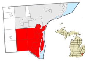
Downriver is a region of the Detroit metropolitan area in the U.S. state of Michigan. Most definitions of the region include the communities in Wayne County, south of Detroit, along the western shore of the Detroit River.
Gabriel Richard Catholic High School
High school in Riverview, Michigan
Distance: Approx. 2528 meters
Latitude and longitude: 42.18305556,-83.20944444
Gabriel Richard Catholic High School, usually referred to as Gabriel Richard or simply GR, is a Catholic, coed high school in Riverview, Michigan, United States, south of Detroit. Named after Father Gabriel Richard, the school was established in 1965, with the first class graduating in 1969. It currently has approximately 300 students and approximately 25 full-time teachers, giving a student-to-teacher ratio of approximately 12:1.
WLQV
Radio station in Detroit, Michigan
Distance: Approx. 2888 meters
Latitude and longitude: 42.23111111,-83.19944444
WLQV (1500 AM) is a commercial radio station licensed to Detroit, Michigan. It is owned by the Salem Media Group and broadcasts a Christian talk and teaching radio format. It uses paid brokered programming where hosts buy time on the station and may seek donations to their ministries during their programs.

Southgate Shopping Center
Shopping center in Michigan, United States
Distance: Approx. 1518 meters
Latitude and longitude: 42.1977,-83.1908
Southgate Shopping Center is a shopping center located at the southeast corner of Eureka and Trenton Roads in Southgate, Michigan. Completed by 1958, it was one of the first major strip malls in the southern Detroit suburbs until the nearby Southland Center opened in 1970. At its peak, the center housed over thirty stores.
Our Lady of Mount Carmel Church (Wyandotte, Michigan)
Church in Michigan, United States
Distance: Approx. 3388 meters
Latitude and longitude: 42.20623,-83.16472
Our Lady of Mount Carmel Church (Polish: Kościół Matki Bożej Szkaplerznej) is located at 976 Pope John Paul II Ave. in the Detroit suburb of Wyandotte, Michigan. Following a parish merger on August 1, 2013, Our Lady of Mount Carmel Church serves the Roman Catholic Polish Personal Parish of Our Lady of the Scapular.

Southgate Anderson High School
High school in Southgate, Michigan
Distance: Approx. 1704 meters
Latitude and longitude: 42.191,-83.212
Southgate Thomas J. Anderson High School is a public high school in Southgate, Michigan, United States. A part of the Southgate Community School District, it serves Southgate and a section of Allen Park.

Our Lady of Mount Carmel High School (Wyandotte, Michigan)
Private, coeducational school in Wyandotte, , Michigan, United States
Distance: Approx. 3413 meters
Latitude and longitude: 42.20694444,-83.16444444
Our Lady of Mount Carmel High School, (Polish: Matki Bożej Szkaplerznej Wyższej Szkoły) was a private, Roman Catholic high school in Wyandotte, Michigan to the parish of Our Lady of Mount Carmel. It closed in June, 2011 due to low enrollment.
Aquinas High School (Michigan)
School
Distance: Approx. 963 meters
Latitude and longitude: 42.21208333,-83.21352778
Aquinas High School was a grades 9-12 parochial high school located in the Detroit suburb of Southgate.
Mallie's Sports Grill & Bar
Restaurant in Southgate, Michigan, U.S.
Distance: Approx. 1979 meters
Latitude and longitude: 42.213134,-83.227542
Mallie's Sports Grill & Bar was a restaurant, sports grill, and bar located in Southgate, Michigan. It was established in 2005. It is best known for setting the world record for the biggest hamburger commercially available.

Old Homestead, Southgate, Michigan
Place in Michigan, United States
Distance: Approx. 1955 meters
Latitude and longitude: 42.2,-83.18333333
Old Homestead is a neighborhood on the east side of the Metro Detroit suburb of Southgate, Michigan. Usually, Old Homestead is bordered by Superior Street to the north, Eureka Road to the south, M-85 (Fort Street) to the east and either Trenton Road or Burns Street to the west. Commercial districts are located along Eureka Road and Fort Street and the rest of the neighborhood is mostly single-family homes, most of which were built during the 1940s and 1950s.

Southgate Tower
Office, retail (former), Residential (planned) in Southgate-Detroit, United States
Distance: Approx. 2246 meters
Latitude and longitude: 42.18861111,-83.19111111
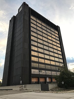
Southgate Tower is a high-rise office building at 16333 Trenton Road in Southgate, Michigan. Since its completion, it has been the tallest building in the Downriver area of Wayne County, Michigan, as well as the tallest building between Detroit and Toledo, Ohio. A large portion of office space in the building was occupied by PNC Financial Services.
Weather in this IP's area
light snow
1 Celsius
-4 Celsius
0 Celsius
1 Celsius
1008 hPa
55 %
1008 hPa
985 hPa
10000 meters
4.63 m/s
290 degree
100 %

