Country:
 Brazil
Region:
City:
Latitude and Longitude:
Time Zone:
Postal Code:
IP information under different IP Channel
ip-api
Country
Region
City
ASN
Time Zone
ISP
Blacklist
Proxy
Latitude
Longitude
Postal
Route
IPinfo
Country
Region
City
ASN
Time Zone
ISP
Blacklist
Proxy
Latitude
Longitude
Postal
Route
MaxMind
Country
Region
City
ASN
Time Zone
ISP
Blacklist
Proxy
Latitude
Longitude
Postal
Route
Luminati
Country
BRRegion
pa
City
belem
ASN
Time Zone
America/Belem
ISP
MARTINS.NET SERVICOS DE TELECOMUNICACOES LTDA
Latitude
Longitude
Postal
db-ip
Country
Region
City
ASN
Time Zone
ISP
Blacklist
Proxy
Latitude
Longitude
Postal
Route
ipdata
Country
Region
City
ASN
Time Zone
ISP
Blacklist
Proxy
Latitude
Longitude
Postal
Route
Popular places and events near this IP address

Belém
Capital and largest city of the Brazilian state of Pará
Distance: Approx. 496 meters
Latitude and longitude: -1.45583333,-48.50388889
Belém ([beˈlẽj]; Portuguese for Bethlehem; initially called Nossa Senhora de Belém do Grão-Pará, in English Our Lady of Bethlehem of Great Pará), often called Belém of Pará, is the capital and largest city of the state of Pará in the north of Brazil. It is the gateway to the Amazon River with a busy port, airport, and bus/coach station. Belém lies approximately 100 km (62.1 miles) upriver from the Atlantic Ocean, on the Pará River, which is part of the greater Amazon River system, separated from the larger part of the Amazon delta by Ilha de Marajó (Marajo Island).

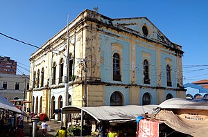
Ver-o-peso
Street market in Belém, Pará, Brazil
Distance: Approx. 494 meters
Latitude and longitude: -1.45222222,-48.50361111
The Ver-o-Peso Market, Mercado Municipal Bolonha de Peixe, Mercado de Ferro, or Ver-o-Peso is a street market and fair, and small port area inaugurated in 1901 (replacing the "Casa de Haver-o-Peso", 1625-1899) that is part of the Ver-o-Peso Complex (1625). It is located in the city of Belém (Pará) in the neighborhood of Campina, on the shores of Guajará Bay, next to the Docks Station. It is considered one of the oldest public markets in the country and was elected one of the wonders of the state of Pará and one of the 7 Wonders of Brazil.
Legislative Assembly of Pará
Distance: Approx. 511 meters
Latitude and longitude: -1.45611111,-48.50388889
The Legislative Assembly of the State of Pará (Portuguese: Assembleia Legislativa do Estado do Pará) is the unicameral legislature of Pará state in Brazil. It has 41 state deputies elected by proportional representation. The first legislature began on March 13, 1885, in a palace where today is the Square Dom Pedro II (destroyed by a fire in 1959), it was moved in 1960 to the Teatro da Paz and in 1970 to the current headquarters, the Palácio Cabanagem.

Palace of the Eleven Windows
Brazilian historical building
Distance: Approx. 273 meters
Latitude and longitude: -1.455075,-48.50577
The House of the Eleven Windows Cultural Space (Portuguese: Espaço Cultural Casa das Onze Janelas), initially called Palace of the Eleven Windows (Portuguese: Palacete das Onze Janelas), is a complex composed of a public square and a historical building located in the Brazilian city of Belém, in Pará. Since 2002 in Brazil, the space houses a contemporary art museum, along with a restaurant and a multicultural area. The building, which was built in the 18th century as a resting house for Domingos da Costa Bacelar, is part of the historical complex called Feliz Lusitânia, which corresponds to the initial historical core of the city of Belém do Pará.

Dom Frei Caetano Brandão Square
Square in Brazil
Distance: Approx. 159 meters
Latitude and longitude: -1.45506583,-48.5073675
The Dom Frei Caetano Brandão Square (Portuguese: Praça Dom Frei Caetano Brandão), originally called Largo da Sé, is located in the Cidade Velha neighborhood in the Brazilian city of Belém, capital of the state of Pará. The square was the meeting point between colonists and indigenous people, as well as the initial mark of the colonization of Belém and the region. It had its peak during the rubber cycle, which enriched and modernized Belém's society.
Solar da Beira
Brazilian historic building
Distance: Approx. 541 meters
Latitude and longitude: -1.45193,-48.50327
Solar da Beira is a public building designed in the neoclassical architectural style that integrates the Ver-o-Peso Complex. It is located in the Brazilian city of Belém, Pará, in the Cidade Velha neighborhood, on the shores of Guajará Bay. There is no record of its construction, but it is believed to have been built in the 19th century, shortly after the Ver-o-Peso Market, which dates back to 1901.
Ver-o-Peso Complex
Architectural complex in Belém, Pará, Brazil
Distance: Approx. 466 meters
Latitude and longitude: -1.45361111,-48.50361111
The Ver-o-Peso Complex (Portuguese: Complexo do Ver-o-Peso) is an architectural and landscape site located on Boulevard Castilhos França, in the Cidade Velha neighborhood, Belém, capital of Pará. It began to be formed in 1625 with the construction of the Casa de Haver-o-Peso commercial tax office, and in 1977 it was listed as a heritage site by the National Institute of Historic and Artistic Heritage (IPHAN). The complex covers an area of 35,000 m2 and includes several historic buildings in line with the French art nouveau trend of the Belle Époque, such as: Boulevard Castilhos França: designed under the art nouveau influence, it was one of the first wide roads in the city; Ver-o-Peso Market: the city's greatest architectural attraction; it replaced the Casa de Haver-o-Peso, which was demolished in 1899.

Siqueira Campos Square
Public space in Belém, Pará, Brazil
Distance: Approx. 452 meters
Latitude and longitude: -1.45393938,-48.50374728
The Siqueira Campos Square (Portuguese: Praça Siqueira Campos) or Clock Square (Praça do Relógio) is a public space located at the Ver-o-Peso Dock, in the Cidade Velha neighborhood, in the Brazilian city of Belém, capital of Pará. The site, which is known for housing a huge English clock, comprises a total area of 2,727.45m², 1,246.78m² of paved area and 1,480.67m² of green area.

Ver-o-Peso Dock
Municipal fair in Belém, Pará, Brazil
Distance: Approx. 468 meters
Latitude and longitude: -1.45333333,-48.50361111
Ver-o-Peso Dock (Portuguese: Doca do Ver-o-Peso) is an open-air municipal public fish market and a small port area that belongs to the Ver-o-Peso Complex, located on the shores of Guajará Bay in the Cidade Velha neighborhood, in the city of Belém, the capital of Pará, Brazil. The dock is surrounded by the Clock Square, the Açaí Fair and the Ver-o-Peso Market.

Solar Barão de Guajará
Historic building in Belém, Pará, Brazil
Distance: Approx. 466 meters
Latitude and longitude: -1.45554,-48.50404
Solar Barão de Guajará, also known as Casa à Praça Pedro II (English: House on Pedro II Square), is a manor house located in Belém, the capital of the state of Pará, Brazil, more specifically in the Dona Tomázia Perdigão Street. It was built in the 19th century and has three floors, the last of which is smaller. The inner courtyard shows elements of the Moorish influence on Iberian architecture.

Church of Our Lady of Mount Carmel (Belém)
Catholic temple in Belém, Pará, Brazil
Distance: Approx. 573 meters
Latitude and longitude: -1.45833333,-48.50555556
The Church of Our Lady of Mount Carmel (Portuguese: Igreja de Nossa Senhora do Carmo) is a Catholic church located in the historic center of Belém. The current building dates back to the 18th century and was designed by several architects, including Antônio Landi. It was restored in 2015 on the initiative of the Archdiocese of Belém do Pará in partnership with Vale and the National Institute of Historical and Artistic Heritage (IPHAN).

Historic and Geographic Institute of Pará
Brazilian organization
Distance: Approx. 468 meters
Latitude and longitude: -1.45553,-48.50401
The Historic and Geographic Institute of Pará (Portuguese: Instituto Histórico e Geográfico do Pará), or IHGP, is a private non-profit institution based in the Barão de Guajará Manor House, in the Brazilian city of Belém. It was founded on May 3, 1900, during the celebrations of the 4th Centenary of the discovery of Brazil. The association holds 70 seats occupied by people from Pará's historiography and academic community.
Weather in this IP's area
light rain
30 Celsius
33 Celsius
29 Celsius
30 Celsius
1009 hPa
63 %
1009 hPa
1009 hPa
10000 meters
3.6 m/s
10 degree
40 %
06:04:32
18:10:55