45.45.188.249 - IP Lookup: Free IP Address Lookup, Postal Code Lookup, IP Location Lookup, IP ASN, Public IP
Country:
 USA
USARegion:
City:
Location:
Time Zone:
Postal Code:
ISP:
ASN:
language:
User-Agent:
Proxy IP:
Blacklist:
IP information under different IP Channel
ip-api
Country
Region
City
ASN
Time Zone
ISP
Blacklist
Proxy
Latitude
Longitude
Postal
Route
db-ip
Country
Region
City
ASN
Time Zone
ISP
Blacklist
Proxy
Latitude
Longitude
Postal
Route
IPinfo
Country
Region
City
ASN
Time Zone
ISP
Blacklist
Proxy
Latitude
Longitude
Postal
Route
IP2Location
45.45.188.249Country
usRegion
kansas
City
baldwin city
Time Zone
America/Chicago
ISP
Language
User-Agent
Latitude
Longitude
Postal
ipdata
Country
Region
City
ASN
Time Zone
ISP
Blacklist
Proxy
Latitude
Longitude
Postal
Route
Popular places and events near this IP address

Baldwin City, Kansas
City in Kansas, United States
Distance: Approx. 369 meters
Latitude and longitude: 38.77805556,-95.18805556
Baldwin City is a city in Douglas County, Kansas, United States, about 12 miles (19 km) south of Lawrence. As of the 2020 census, the population of the city was 4,826. The city is home to Baker University, the state's oldest four-year university.

Baker University
Private university in Baldwin City, Kansas, U.S.
Distance: Approx. 303 meters
Latitude and longitude: 38.7775,-95.18777778
Baker University is a private university in Baldwin City, Kansas, United States. Founded in 1858, it was the first four-year university in Kansas and is affiliated with the United Methodist Church. Baker University is made up of four schools.

Midland Railway (Kansas)
Distance: Approx. 1253 meters
Latitude and longitude: 38.77472222,-95.20083333
The Midland Railway was a heritage railroad operating 16 miles of line in Franklin County and Douglas County in Kansas between Ottawa, Kansas and Baldwin City, Kansas. It was chartered in 1982 to find an abandoned railroad line to operate. Midland purchased the line from Baldwin City to Ottawa from the Atchison, Topeka and Santa Fe Railway ("AT&SF") in 1987, and began running excursion trains on part of the line later that year.

Prairie City, Kansas
Ghost town in Kansas, United States
Distance: Approx. 2855 meters
Latitude and longitude: 38.76027778,-95.21333333
Prairie City is a ghost town in southeast Douglas County, Kansas, United States, near present-day Baldwin City.

Palmyra Township, Douglas County, Kansas
Township in Kansas, United States
Distance: Approx. 3495 meters
Latitude and longitude: 38.78888889,-95.15027778
Palmyra Township is a township in Douglas County, Kansas, USA. As of 2000 census, its population was 5,760. It was named after a small trail stop on the Santa Fe Trail that was later absorbed into Baldwin City. When it was first established in 1855, it was called Calhoun, until 1858.

Baldwin High School (Kansas)
Public high school in Baldwin City, Douglas, Kansas, United States
Distance: Approx. 1233 meters
Latitude and longitude: 38.78566667,-95.18255556
Baldwin High School is a public secondary school in Baldwin, Kansas, United States. It is operated by the Baldwin City USD 348 school district.

Liston Stadium
Sport stadium in Baldwin City, Kansas, United States
Distance: Approx. 723 meters
Latitude and longitude: 38.7765,-95.17829
Liston Stadium is a sport stadium in Baldwin City, Kansas, United States. The facility is primarily used by Baker University for college football, track and field, and soccer. It is also host to other university and city athletic and non-athletic events.

Old Castle Hall
United States historic place
Distance: Approx. 300 meters
Latitude and longitude: 38.77722222,-95.18444444
Old Castle Hall was the first building of Baker University in Baldwin City, Kansas. It was built in 1857–58 to house the university on its first two floors, with the Palmyra Masonic Lodge occupying the third floor. It was used for classes until 1871, when other buildings were constructed for the purpose, and later used as a mill, a dormitory and for storage.
Media, Kansas
Ghost town in Kansas, United States
Distance: Approx. 1408 meters
Latitude and longitude: 38.77222222,-95.20222222
Media is a ghost town in Douglas County, Kansas, United States.
Louisiana, Kansas
Ghost town in Douglas County, Kansas
Distance: Approx. 3838 meters
Latitude and longitude: 38.80417,-95.20997
Louisiana (also known as Brooklyn and Salem) is a ghost town in Douglas County, Kansas, United States.
Baldwin Woods
Natural area in Kansas, United States
Distance: Approx. 3897 meters
Latitude and longitude: 38.81,-95.187
Baldwin Woods, formally called the Baldwin Woods Forest Preserve, is a 456-acre (185 ha) nature reserve in Douglas County in the U.S. state of Kansas. The forest preserve is located near the municipality of Vinland within the Lawrence, Kansas metropolitan area. Formerly a 3,700-acre (1,500 ha) old-growth forest grove of white oak and hickory, with interspersed tallgrass prairie savanna, the old-growth portion of the forest preserve has been reduced to its present size.
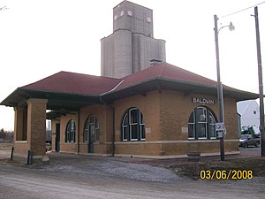
Baldwin City station
United States historic place
Distance: Approx. 1277 meters
Latitude and longitude: 38.77472222,-95.20111111
The Baldwin City station, nominated as the Santa Fe Depot, is a historic railroad depot building at 1601 High Street in Baldwin City, Kansas. The depot was on the Lawrence to Ottawa line of the Atchison, Topeka and Santa Fe Railway. It was built to replace a wood frame depot, which was deemed inadequate for the growing city.
Weather in this IP's area
scattered clouds
3 Celsius
-0 Celsius
3 Celsius
4 Celsius
1022 hPa
55 %
1022 hPa
985 hPa
10000 meters
3.58 m/s
7.15 m/s
78 degree
33 %