Country:
 Canada
Region:
City:
Latitude and Longitude:
Time Zone:
Postal Code:
IP information under different IP Channel
ip-api
Country
Region
City
ASN
Time Zone
ISP
Blacklist
Proxy
Latitude
Longitude
Postal
Route
IPinfo
Country
Region
City
ASN
Time Zone
ISP
Blacklist
Proxy
Latitude
Longitude
Postal
Route
MaxMind
Country
Region
City
ASN
Time Zone
ISP
Blacklist
Proxy
Latitude
Longitude
Postal
Route
Luminati
Country
CARegion
qc
ASN
Time Zone
America/Toronto
ISP
DISTRIBUTEL-AS11814
Latitude
Longitude
Postal
db-ip
Country
Region
City
ASN
Time Zone
ISP
Blacklist
Proxy
Latitude
Longitude
Postal
Route
ipdata
Country
Region
City
ASN
Time Zone
ISP
Blacklist
Proxy
Latitude
Longitude
Postal
Route
Popular places and events near this IP address
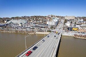
Saint-Georges, Quebec
City in south-eastern Quebec, Canada
Distance: Approx. 748 meters
Latitude and longitude: 46.11666667,-70.66666667
Saint-Georges (French pronunciation: [sɛ̃ ʒɔʁʒ] ) is a city in the province of Quebec, Canada. It is the seat of Beauce-Sartigan Regional County Municipality, part of the Chaudière-Appalaches region. The population was 32,935 as of the Canada 2021 Census.
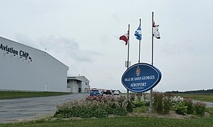
Saint-Georges Aerodrome
Airport in Saint-Georges, Quebec
Distance: Approx. 4507 meters
Latitude and longitude: 46.09638889,-70.71444444
Saint-Georges Aerodrome (ICAO: CYSG) is a general aviation aerodrome located 1.5 nautical miles (2.8 km; 1.7 mi) west-southwest of Saint-Georges, Quebec, Canada, near the border with Maine. The airport has a long, paved runway, suitable for use by jets. The airport is classified as an airport of entry by Nav Canada and is staffed by the Canada Border Services Agency (CBSA).
Beauce, Quebec
Distance: Approx. 748 meters
Latitude and longitude: 46.11666667,-70.66666667
Beauce (; French pronunciation: [bos]) is a historical and traditional region of Quebec, Canada, located south of Quebec City. It corresponds approximately to the regional county municipalities of Beauce-Sartigan, Beauce-Centre and La Nouvelle-Beauce, and its major communities are Saint-Georges, Sainte-Marie, Beauceville, Saint-Joseph-de-Beauce and Saint-Victor.

Centre Sportif Lacroix-Dutil
Sports arena in Quebec, Canada
Distance: Approx. 822 meters
Latitude and longitude: 46.12372,-70.68089
The Centre Sportif Lacroix-Dutil is a multi-purpose arena in Saint-Georges, Quebec, Canada. It has a capacity of 2,476.
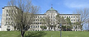
Cégep Beauce-Appalaches
Vocational college in Quebec, Canada
Distance: Approx. 298 meters
Latitude and longitude: 46.125525,-70.66953611
Cégep Beauce-Appalaches is a CEGEP in Saint-Georges, Quebec, Canada.
CKRB-FM
Radio station in Saint-Georges, Quebec
Distance: Approx. 7159 meters
Latitude and longitude: 46.15888889,-70.74722222
CKRB-FM (Cool FM 103,5) is a French-language Canadian radio station located in Saint-Georges, Quebec. Owned and operated by Radio Beauce, a subsidiary of Groupe Radio Simard, it broadcasts on 103.5 MHz with an effective radiated power of 17,000 watts (class B) using an omnidirectional antenna.
CHJM-FM
Radio station in Saint-Georges, Quebec
Distance: Approx. 7159 meters
Latitude and longitude: 46.15888889,-70.74722222
CHJM-FM is a French-language Canadian radio station located in Saint-Georges, Quebec. Owned and operated by Groupe Radio Simard, it broadcasts on 99.7 MHz using a directional antenna with an average effective radiated power of 100,000 watts (class C1). The station has a CHR/Top 40 format branded as Mix 99,7.

Carrefour Saint-Georges
Shopping mall in Quebec, Canada
Distance: Approx. 479 meters
Latitude and longitude: 46.1218,-70.6763
The Carrefour Saint-Georges is a shopping centre located in Saint-Georges, Quebec, Canada which opened in 1974. Its current anchors include Super C and Bureau en Gros.

Notre-Dame-des-Pins, Quebec
Parish municipality in Quebec, Canada
Distance: Approx. 7619 meters
Latitude and longitude: 46.18333333,-70.71666667
Notre-Dame-des-Pins is a parish municipality in the Beauce-Sartigan Regional County Municipality in the Chaudière-Appalaches region of Quebec, Canada. Its population is 1,812 as of the Canada 2021 Census. Notre-Dame-des-Pins is known for its covered bridge crossing the Chaudière River.
Commission scolaire des Navigateurs
School district in Quebec, Canada
Distance: Approx. 816 meters
Latitude and longitude: 46.12805556,-70.66277778
Commission scolaire des Navigateurs was a French-language school district in Lévis, Quebec, Canada. Its address was in Saint-Romuald, a former town annexed to Lévis. The chair of the school board was Jérôme Demers, and the director general was Esther Lemieux.

Pozer River
River in Chaudière-Appalaches, Quebec (Canada)
Distance: Approx. 7581 meters
Latitude and longitude: 46.05783,-70.69928
The Pozer River (in French: rivière Pozer) is a river that originates in Shenley Township and flows into the Chaudière River at Saint-Georges. The latter flows northward to empty onto the south shore of the St. Lawrence River.

Rivière du Loup (Chaudière River tributary)
River in Beauce-Sartigan and Estrie, Quebec, Canada
Distance: Approx. 4008 meters
Latitude and longitude: 46.08944,-70.65111
The rivière du Loup (in English: river of Wolf) is a tributary of the east bank of the Chaudière River which flows northward to empty onto the south bank of the St. Lawrence River, in the region administrative office of Chaudière-Appalaches, in Quebec, in Canada. The rivière du Loup empties on the east bank of the Chaudière River at a place called Sartigan, near Saint-Georges.
Weather in this IP's area
clear sky
5 Celsius
5 Celsius
5 Celsius
8 Celsius
1033 hPa
81 %
1033 hPa
1008 hPa
10000 meters
0.51 m/s
190 degree
07:04:13
17:50:55