Country:
Region:
City:
Latitude and Longitude:
Time Zone:
Postal Code:
IP information under different IP Channel
ip-api
Country
Region
City
ASN
Time Zone
ISP
Blacklist
Proxy
Latitude
Longitude
Postal
Route
Luminati
Country
ASN
Time Zone
Asia/Yangon
ISP
MYANMA POSTS AND TELECOMMUNICATIONS
Latitude
Longitude
Postal
IPinfo
Country
Region
City
ASN
Time Zone
ISP
Blacklist
Proxy
Latitude
Longitude
Postal
Route
db-ip
Country
Region
City
ASN
Time Zone
ISP
Blacklist
Proxy
Latitude
Longitude
Postal
Route
ipdata
Country
Region
City
ASN
Time Zone
ISP
Blacklist
Proxy
Latitude
Longitude
Postal
Route
Popular places and events near this IP address
Lanmadaw Township
Township of Yangon in Myanmar
Distance: Approx. 444 meters
Latitude and longitude: 16.78083333,96.14972222
Lanmadaw Township (Burmese: လမ်းမတော် မြို့နယ်; MLCTS=lam: ma. taw mrui. nai; pronounced [láɰ̃mədɔ̀ mjo̰nɛ̀]) is located in the western part of downtown Yangon, and shares borders with Ahlone Township in the west, Latha Township in the east, Seikkan Township and Yangon River in the south, and Dagon Township in the north.

Bogyoke Aung San Stadium
Multi-purpose sports stadium in Myanmar
Distance: Approx. 791 meters
Latitude and longitude: 16.78386111,96.160725
The Bogyoke Aung San Stadium (Burmese: ဗိုလ်ချုပ် အောင်ဆန်း အားကစားကွင်း; MLCTS: buil hkyup aung hcan: a: ka. ca: kwang:) is a multi-purpose stadium, located in downtown Yangon, Myanmar. It was built as an athletic ground in 1906, which was completed in 1909 and named as Burma Athletic Association Ground, where many sports were held such as cricket, football and tennis.
Bogyoke Market
Shopping mall in Yangon, Myanmar
Distance: Approx. 349 meters
Latitude and longitude: 16.78037778,96.1556
Bogyoke Aung San Market (Burmese: ဗိုလ်ချုပ်အောင်ဆန်းဈေး; formerly the Scott Market) is a major bazaar located in Pabedan township in central Yangon, Myanmar. Known for its colonial architecture and inner cobblestone streets, the market is a major tourist destination, dominated by antique, Burmese handicraft and jewellery shops, art galleries, and clothing stores. Bogyoke Market is a popular black market location to exchange currency.

Shri Kali Temple, Burma
Hindu temple in Yangon Region, Burma
Distance: Approx. 618 meters
Latitude and longitude: 16.77724444,96.15446667
Shri Kali Temple is a Hindu temple located in the undefined Little India in downtown Yangon, Burma. It was built by Tamil migrants in 1871, whilst Burma Province was part of British India. The temple is noted for its colorful architecture, especially its roof, which contains images and stone carvings of many Hindu gods.

Yangon General Hospital
Hospital in Yangon Region, Myanmar
Distance: Approx. 710 meters
Latitude and longitude: 16.77888889,96.14805556
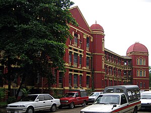
The Yangon General Hospital (YGH, Burmese: ရန်ကုန် ပြည်သူ့ ဆေးရုံကြီး) is a major public hospital in a 14-hectare (35-acre) compound in Yangon, Myanmar. The 2,000-bed hospital consists of seven medical wards, three surgical wards, two trauma and orthopaedic wards, and 28 specialist departments for inpatient care. The hospital also runs an ER for general medicine, general surgery and traumatology.

Basic Education High School No. 2 Dagon
Public school in Yangon, Yangon Region, Myanmar
Distance: Approx. 712 meters
Latitude and longitude: 16.78574167,96.14752778
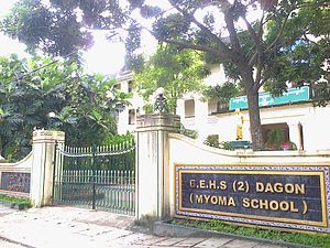
Basic Education High School No. 2 Dagon (Burmese: အခြေခံ ပညာ အထက်တန်း ကျောင်း အမှတ် (၂) ဒဂုံ; formerly, Myoma National High School, မြို့မကျောင်း) is a public high school located a few miles north of downtown Yangon, Myanmar. The former nationalist high school founded for the children of the common folk, now educates mostly the children of well-to-do Burmese families from Dagon and vicinity.

Dagon Township
Township of Yangon in Myanmar
Distance: Approx. 444 meters
Latitude and longitude: 16.78083333,96.14972222
Dagon Township (Burmese: ဒဂုံ မြို့နယ် [dəɡòʊɰ̃ mjo̰nɛ̀]) is located immediately north of downtown Yangon. The township comprises five wards, and shares borders with Bahan Township in the north, Ahlon Township in the west, Mingala Taungnyunt Township in the east, and Lanmadaw Township, Latha Township and Pabedan Township in the south. Dagon is home to some of the most prominent places of the city, including the great Shwedagon Pagoda, the Maha Wizaya Pagoda, the National Museum, the National Theatre and the Yangon Region Hluttaw (Parliament).
Latha Township
Township of Yangon in Myanmar
Distance: Approx. 444 meters
Latitude and longitude: 16.78083333,96.14972222
Latha Township (Burmese: လသာ မြို့နယ်, pronounced [la̰ðà mjo̰nɛ̀]) is located in the western part of downtown Yangon, and shares borders with Lanmadaw township in the west, Pabedan township in the east, Seikkan township and Yangon river in the south, and Dagon township in the north. It consists of ten wards and is home to three primary schools, one middle school and two high schools. Lanmadaw and Latha Townships make up the Yangon Chinatown.

Pabedan Township
Township of Yangon in Myanmar
Distance: Approx. 354 meters
Latitude and longitude: 16.78027778,96.15555556
Pabedan Township (Burmese: ပန်းဘဲတန်း မြို့နယ်, pronounced [bəbɛ́dáɰ̃ mjo̰nɛ̀]) is located in the center of downtown Yangon, Myanmar. The township is home to Bogyoke Aung San Market and Theingyi Market, two of the largest markets in all of Yangon. The township consists of eleven wards, and shares borders with Kyauktada township in the east, Seikkan township and Yangon river in the south, Latha township in the west and Dagon township in the north.
Holy Trinity Cathedral, Yangon
Anglican cathedral in Myanmar
Distance: Approx. 300 meters
Latitude and longitude: 16.78003333,96.15383611
Holy Trinity Cathedral (Burmese: သန့်ရှင်းသော တြိနတိ ကသီဒြယ်, IPA: [θa̰ɰ̃ʃɪ́ɰ̃ ðɔ́ tɹḭnətḭ kəθìdɹɛ̀]) is the primary Anglican cathedral in Myanmar (Burma), located on Bogyoke Aung San Road (next to Bogyoke Aung San Market) in Latha Township, Yangon. The cathedral was designed by Robert Chisholm, a Madras-based architect, in the Indo-Saracenic style to adapt to warm and humid conditions. Construction began in 1886, with the laying of the foundation stone by Lord Dufferin, the Viceroy of India, and was completed in 1894.

Sule Shangri-La Hotel
Hotel in Kyauktada, Yangon
Distance: Approx. 507 meters
Latitude and longitude: 16.7791473,96.1563784
Sule Shangri-La Hotel (formerly, Traders Hotel) is a hotel located in downtown Yangon. It was the tallest building in Myanmar from 1996 to 1999. The 466-room hotel used to be known as Traders Hotel before it was rebranded in 2014 as Sule Shangri-La Yangon by its owner Shangri-La Hotels and Resorts.

Jubilee Hall, Rangoon
Distance: Approx. 264 meters
Latitude and longitude: 16.784921,96.152521
Jubilee Hall (Burmese: ဂျူဗလီဟော) was a colonial-era landmark in Rangoon, Burma of historical significance, and considered "one of the best appointed theatres in the Orient" during the early part of the 20th century.
Weather in this IP's area
scattered clouds
32 Celsius
38 Celsius
32 Celsius
32 Celsius
1010 hPa
62 %
1010 hPa
1007 hPa
8000 meters
4.12 m/s
10 degree
29 %
06:10:09
17:30:26

