45.4.22.93 - IP Lookup: Free IP Address Lookup, Postal Code Lookup, IP Location Lookup, IP ASN, Public IP
Country:
Region:
City:
Location:
Time Zone:
Postal Code:
ISP:
ASN:
language:
User-Agent:
Proxy IP:
Blacklist:
IP information under different IP Channel
ip-api
Country
Region
City
ASN
Time Zone
ISP
Blacklist
Proxy
Latitude
Longitude
Postal
Route
db-ip
Country
Region
City
ASN
Time Zone
ISP
Blacklist
Proxy
Latitude
Longitude
Postal
Route
IPinfo
Country
Region
City
ASN
Time Zone
ISP
Blacklist
Proxy
Latitude
Longitude
Postal
Route
IP2Location
45.4.22.93Country
Region
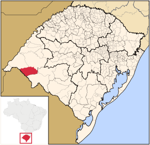
rio grande do sul
City
quarai
Time Zone
America/Sao_Paulo
ISP
Language
User-Agent
Latitude
Longitude
Postal
ipdata
Country
Region
City
ASN
Time Zone
ISP
Blacklist
Proxy
Latitude
Longitude
Postal
Route
Popular places and events near this IP address
Artigas, Uruguay
Capital city in Artigas, Uruguay
Distance: Approx. 8934 meters
Latitude and longitude: -30.46666667,-56.46666667
Artigas (Spanish pronunciation: [aɾˈtiɣas]) is the capital of the Artigas Department of Uruguay. Its name comes from that of the national hero, José Gervasio Artigas, who fought for the emancipation of the River Plate, and sought to create a federative nation from these colonies. As of the census of 2011, it is the eleventh most populous city in the country.

Quaraí
Municipality in South, Brazil
Distance: Approx. 1 meters
Latitude and longitude: -30.3875,-56.45138889
Quarai is a Brazilian municipality located near the border with Uruguay on the Rio Quaraí. The population is 22,607 (2020 est.) in an area of 3,147.63 km2, making it one of the largest municipalities in the state. Its elevation is 112 m.
Pintadito
Suburb of Artigas in Artigas Department, Uruguay
Distance: Approx. 5221 meters
Latitude and longitude: -30.43388889,-56.45944444
Pintadito is a southern suburb of the capital city Artigas of Artigas Department in northern Uruguay.

Artigas Airport
Airport
Distance: Approx. 5665 meters
Latitude and longitude: -30.40083333,-56.50833333
Artigas International Airport (IATA: ATI, ICAO: SUAG) is an airport serving Artigas, capital of the Artigas Department of Uruguay. The airport is 2 kilometres (1 mi) west of the city, and is close to the border with Brazil. The airport was opened in November 1973.
Cerro Ejido
Suburb of Artigas in Artigas Department, Uruguay
Distance: Approx. 5160 meters
Latitude and longitude: -30.43333333,-56.45944444
Cerro Ejido is a suburb of the city of Artigas in the Artigas Department of northern Uruguay.
Weather in this IP's area
scattered clouds
38 Celsius
36 Celsius
38 Celsius
38 Celsius
1010 hPa
20 %
1010 hPa
995 hPa
10000 meters
3.6 m/s
4.02 m/s
167 degree
45 %
