45.4.21.243 - IP Lookup: Free IP Address Lookup, Postal Code Lookup, IP Location Lookup, IP ASN, Public IP
Country:
Region:
City:
Location:
Time Zone:
Postal Code:
IP information under different IP Channel
ip-api
Country
Region
City
ASN
Time Zone
ISP
Blacklist
Proxy
Latitude
Longitude
Postal
Route
Luminati
Country
Region
rs
City
dompedrito
ASN
Time Zone
America/Sao_Paulo
ISP
Osirnet Info Telecom Ltda.
Latitude
Longitude
Postal
IPinfo
Country
Region
City
ASN
Time Zone
ISP
Blacklist
Proxy
Latitude
Longitude
Postal
Route
IP2Location
45.4.21.243Country
Region
rio grande do sul
City
santana do livramento
Time Zone
America/Sao_Paulo
ISP
Language
User-Agent
Latitude
Longitude
Postal
db-ip
Country
Region
City
ASN
Time Zone
ISP
Blacklist
Proxy
Latitude
Longitude
Postal
Route
ipdata
Country
Region
City
ASN
Time Zone
ISP
Blacklist
Proxy
Latitude
Longitude
Postal
Route
Popular places and events near this IP address

Rivera
Capital city in Uruguay
Distance: Approx. 2138 meters
Latitude and longitude: -30.9025,-55.55055556
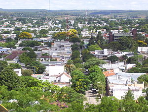
Rivera (Spanish pronunciation: [riˈβeɾa]) is the capital of Rivera Department of Uruguay. The border with Brazil joins it with the Brazilian city of Santana do Livramento, which is only a block away from it, at the north end of Route 5. Together, they form an urban area of around 200,000 inhabitants.

Estadio Atilio Paiva Olivera
Distance: Approx. 2452 meters
Latitude and longitude: -30.90833333,-55.54833333
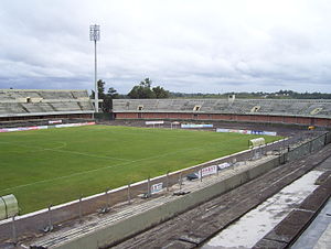
Estadio Atilio Paiva Olivera is a multi-use stadium in Rivera, Uruguay. It is currently used mostly for football matches. The stadium holds 27,135 people.

Santana do Livramento
Municipality in South, Brazil
Distance: Approx. 1481 meters
Latitude and longitude: -30.8775,-55.53305556
Santana do Livramento, also spelled Sant'Ana do Livramento, is a city in the state of Rio Grande do Sul, Brazil. It is located along the border with the city of Rivera, Uruguay, forming together an international city of almost 170,000 inhabitants. Santana do Livramento was founded on 30 July 1823, and in 1857 was emancipated from Alegrete as a city.
La Pedrera, Rivera
Hamlet in Rivera Department, Uruguay
Distance: Approx. 5012 meters
Latitude and longitude: -30.93333333,-55.55
La Pedrera is a hamlet and southern suburb of Rivera in the Rivera Department of northeastern Uruguay. It is a peripheral area to the city of Rivera and, together with Mandubí, they form a southern extension of the city.
Lagunón
Barrio of Rivera in Rivera Department, Uruguay
Distance: Approx. 4899 meters
Latitude and longitude: -30.88333333,-55.58333333
Lagunón is a barrio (neighbourhood) at the northwest end of the city of Rivera in the Rivera Department of northeastern Uruguay.
Mandubí
Suburb of Rivera in Rivera Department, Uruguay
Distance: Approx. 4594 meters
Latitude and longitude: -30.92777778,-55.55416667
Mandubí is a southern suburb of the city of Rivera in the Rivera Department of northeastern Uruguay.
Santa Teresa, Uruguay
Suburb of Rivera in Rivera Department, Uruguay
Distance: Approx. 5620 meters
Latitude and longitude: -30.91666667,-55.58333333
Santa Teresa is a suburb of Rivera, the capital city of the Rivera Department of northeastern Uruguay.

Sudoeste Rio-Grandense
Mesoregion in Rio Grande do Sul, Brazil
Distance: Approx. 0 meters
Latitude and longitude: -30.8908,-55.5328
Sudoeste Rio-Grandense (Southwest of Rio Grande) is one of the seven mesoregions of the state of Rio Grande do Sul in Brazil.

Microregion of Campanha Central
Micro-region in Rio Grande do Sul, Brazil
Distance: Approx. 4 meters
Latitude and longitude: -30.89083333,-55.53277778
The Campanha Central micro-region (Microrregião de Campanha Central, meaning the central fields in Portuguese) is a microregion in the western part of the state of Rio Grande do Sul, Brazil.

Autódromo Eduardo Prudêncio Cabrera
Motorsport racetrack in Uruguay
Distance: Approx. 7706 meters
Latitude and longitude: -30.86287778,-55.60660278
Autodromo Eduardo Prudêncio Cabrera is a 3.080 km (1.914 mi) motor racing circuit in Rivera. It was inaugurated in September 1951. However, it was abandoned at the end of the 1990s.
Weather in this IP's area
clear sky
31 Celsius
38 Celsius
31 Celsius
31 Celsius
1012 hPa
99 %
1012 hPa
988 hPa
10000 meters
5.47 m/s
5.91 m/s
133 degree