45.4.196.149 - IP Lookup: Free IP Address Lookup, Postal Code Lookup, IP Location Lookup, IP ASN, Public IP
Country:
Region:
City:
Location:
Time Zone:
Postal Code:
ISP:
ASN:
language:
User-Agent:
Proxy IP:
Blacklist:
IP information under different IP Channel
ip-api
Country
Region
City
ASN
Time Zone
ISP
Blacklist
Proxy
Latitude
Longitude
Postal
Route
db-ip
Country
Region
City
ASN
Time Zone
ISP
Blacklist
Proxy
Latitude
Longitude
Postal
Route
IPinfo
Country
Region
City
ASN
Time Zone
ISP
Blacklist
Proxy
Latitude
Longitude
Postal
Route
IP2Location
45.4.196.149Country
Region
new jersey
City
fair lawn
Time Zone
America/New_York
ISP
Language
User-Agent
Latitude
Longitude
Postal
ipdata
Country
Region
City
ASN
Time Zone
ISP
Blacklist
Proxy
Latitude
Longitude
Postal
Route
Popular places and events near this IP address

Fair Lawn, New Jersey
Borough in Bergen County, New Jersey, US
Distance: Approx. 194 meters
Latitude and longitude: 40.935833,-74.117504
Fair Lawn is a borough in Bergen County, in the U.S. state of New Jersey, and a bedroom suburb located 12 miles (19 km) northwest of New York City. As of the 2020 United States census, the borough's population was 34,927, an increase of 2,470 (+7.6%) from the 2010 census count of 32,457, which in turn reflected an increase of 820 (+2.6%) from the 31,637 counted in the 2000 census. Fair Lawn was incorporated as a borough by an act of the New Jersey Legislature on March 6, 1924, as "Fairlawn", from portions of Saddle River Township.

Radburn, New Jersey
Populated place in Bergen County, New Jersey, US
Distance: Approx. 770 meters
Latitude and longitude: 40.9425,-74.11666667
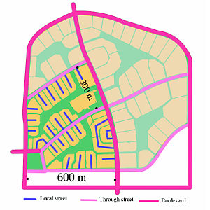
Radburn is an unincorporated community located within the borough of Fair Lawn in Bergen County, in the U.S. state of New Jersey. Radburn was founded in 1929 as "a town for the motor age". Its planners, Clarence Stein and Henry Wright, and its landscape architect Marjorie Sewell Cautley aimed to incorporate modern planning principles, which were then being introduced into England's Garden Cities, following ideas advocated by urban planners Ebenezer Howard, Sir Patrick Geddes and Clarence Perry.

Fair Lawn High School
High school in Bergen County, New Jersey, US
Distance: Approx. 598 meters
Latitude and longitude: 40.93266,-74.125372
Fair Lawn High School is a four-year comprehensive public high school serving students in ninth through twelfth grades, located in Fair Lawn, Bergen County, in the U.S. state of New Jersey, operating as the lone secondary school of the Fair Lawn Public Schools. As of the 2023–24 school year, the school had an enrollment of 1,644 students and 124.9 classroom teachers (on an FTE basis), for a student–teacher ratio of 13.2:1. There were 190 students (11.6% of enrollment) eligible for free lunch and 71 (4.3% of students) eligible for reduced-cost lunch.

Little Diamond Brook
Distance: Approx. 1508 meters
Latitude and longitude: 40.941273,-74.136316
Little Diamond Brook is a tributary of the Passaic River which flows south through a section of Bergen County in New Jersey. Heading up the approximately two mile long brook from the Passaic River, one encounters the towns of Fair Lawn and Glen Rock. Little Diamond Brook is considered to be in part of the Goffle Brook drainage basin, but it has no junctions with Goffle Brook and is separated from it by two brooks, Diamond Brook (a neighboring brook considered to be its larger counterpart), and Stevenson Brook, which both flow south to the Passaic River between Goffle Brook and Little Diamond Brook.
Fair Lawn Public Schools
School district in Bergen County, New Jersey, US
Distance: Approx. 1356 meters
Latitude and longitude: 40.94307,-74.10667
The Fair Lawn Public Schools is a comprehensive community public school district serving students in pre-kindergarten through twelfth grade from Fair Lawn in Bergen County, in the U.S. state of New Jersey. As of the 2022–23 school year, the district, comprised of nine schools, had an enrollment of 5,529 students and 458.4 classroom teachers (on an FTE basis), for a student–teacher ratio of 12.1:1. The district is classified by the New Jersey Department of Education as being in District Factor Group "GH", the third-highest of eight groupings.

Broadway station (NJ Transit)
NJ Transit rail station
Distance: Approx. 1573 meters
Latitude and longitude: 40.9223,-74.1152
Broadway (also known as Broadway–Fair Lawn) is an NJ Transit train station served by the Bergen County Line located in Fair Lawn, in Bergen County, New Jersey, United States. It is one of two NJ Transit train stations in Fair Lawn, the other being Radburn. The station is located on an overpass above Route 4, which is known as Broadway in Elmwood Park and Fair Lawn.

Radburn station
NJ Transit rail station
Distance: Approx. 424 meters
Latitude and longitude: 40.93944444,-74.12194444
Radburn is a New Jersey Transit train station in the Dutch Colonial Revival style, served by the Bergen County Line. It is on Fair Lawn Avenue in the Radburn section of Fair Lawn, in Bergen County, New Jersey, United States. It is one of two New Jersey Transit train stations in Fair Lawn, the other being Broadway.
St. Anne School (Fair Lawn, New Jersey)
Catholic school
Distance: Approx. 1537 meters
Latitude and longitude: 40.9222,-74.1193
St. Anne School, founded in 1949, is a private, parochial elementary school, grades pre-Kindergarten through eighth, located in Fair Lawn, New Jersey. St.

A. Zerega's Sons, Inc.
American pasta manufacturer
Distance: Approx. 1463 meters
Latitude and longitude: 40.92310556,-74.11646389
A. Zerega's Sons, Inc. was a privately owned pasta company with plants in Fair Lawn, New Jersey and Lee's Summit, Missouri. The company was founded by Antoine Zerega in Brooklyn, New York in 1848 making it the first pasta company in the United States.

Jacob Vanderbeck Jr. House
Historic house in New Jersey, United States
Distance: Approx. 1971 meters
Latitude and longitude: 40.94611111,-74.10055556
The Jacob Vanderbeck Jr. House, in Fair Lawn, Bergen County, New Jersey, United States, is a typical historic house of the American colonial architecture style called Dutch Colonial on Dunkerhook Road, adjacent to the Saddle River County Park. It sits on a bluff above the Saddle River (Passaic River) and is approached from Dunkerhook Road via Barrister Court, a condominium development it is now part of.

Cadmus-Folly House
Historic house in New Jersey, United States
Distance: Approx. 416 meters
Latitude and longitude: 40.93861111,-74.12333333
Cadmus-Folly House(Cadmus House) isa historic Dutch-American sandstone house located in Fair Lawn, Bergen County, New Jersey, United States. The house was added to the National Register of Historic Places on January 10, 1983.

Garretson Forge and Farm
United States historic place
Distance: Approx. 1624 meters
Latitude and longitude: 40.92388889,-74.13055556
Garretson Forge and Farm is a farm owned by the Garretson Family since 1719. Located in Fair Lawn, Bergen County, New Jersey, United States, it is one of the oldest historic sites in the county. The Peter Garretson House (also known as Garretson-Brocker Home) was built in 1720 and was added to the National Register of Historic Places on November 19, 1974.
Weather in this IP's area
clear sky
-10 Celsius
-16 Celsius
-12 Celsius
-9 Celsius
1032 hPa
53 %
1032 hPa
1024 hPa
10000 meters
3.09 m/s
300 degree