Country:
 Paraguay
Region:
City:
Latitude and Longitude:
Time Zone:
Postal Code:
IP information under different IP Channel
ip-api
Country
Region
City
ASN
Time Zone
ISP
Blacklist
Proxy
Latitude
Longitude
Postal
Route
IPinfo
Country
Region
City
ASN
Time Zone
ISP
Blacklist
Proxy
Latitude
Longitude
Postal
Route
MaxMind
Country
Region
City
ASN
Time Zone
ISP
Blacklist
Proxy
Latitude
Longitude
Postal
Route
Luminati
Country
PYRegion
13
City
pedrojuancaballero
ASN
Time Zone
America/Asuncion
ISP
MONGELOS ARCE MARCIALDELTA NETWORKS
Latitude
Longitude
Postal
db-ip
Country
Region
City
ASN
Time Zone
ISP
Blacklist
Proxy
Latitude
Longitude
Postal
Route
ipdata
Country
Region
City
ASN
Time Zone
ISP
Blacklist
Proxy
Latitude
Longitude
Postal
Route
Popular places and events near this IP address

Amambay
Department of Paraguay
Distance: Approx. 2360 meters
Latitude and longitude: -22.53,-55.75
Amambay (Spanish pronunciation: [amamˈbaj]) is a department in Paraguay. The capital is Pedro Juan Caballero. The name comes from the name of a part of the Caaguazú Cordillera, "Amambai Mountains".
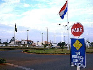
Pedro Juan Caballero, Paraguay
City in Amambay, Paraguay
Distance: Approx. 2360 meters
Latitude and longitude: -22.53,-55.75
Pedro Juan Caballero (Spanish pronunciation: [ˈpeðɾo ˈxwaŋ kaβaˈʎeɾo]) is a Paraguayan city in the Amambay Department of which it is the capital. The city lies on the border with the Brazilian city of Ponta Porã in the state of Mato Grosso do Sul and is known as a centre for cheap electronic and consumer goods, and also as a centre for drug smuggling. This city is the highest city in Paraguay at 670 m (2201 ft) above sea level and is named after Pedro Juan Caballero.
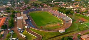
Monumental Río Parapití
Distance: Approx. 1273 meters
Latitude and longitude: -22.53916667,-55.74555556
Monumental Río Parapití is a multi-use stadium in the city of Pedro Juan Caballero, Paraguay, used mostly for football. It is the home venue of Club 2 de Mayo. This stadium was used during the 1999 Copa América, hosting games between Paraguay and Peru and between Japan and Bolivia.

Ponta Porã
Municipality in Central-West, Brazil
Distance: Approx. 1755 meters
Latitude and longitude: -22.53583333,-55.72583333
Ponta Porã is a municipality located in the Brazilian state of Mato Grosso do Sul. Its population is 93,937 (2020) and its area is 5,329 km2. It has a dry border and a conurbation with the city of Pedro Juan Caballero in Paraguay.
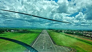
Ponta Porã International Airport
Airport
Distance: Approx. 3518 meters
Latitude and longitude: -22.54972222,-55.70305556
Ponta Porã International Airport (IATA: PMG, ICAO: SBPP) is the airport serving Ponta Porã, Brazil.
Weather in this IP's area
smoke
26 Celsius
26 Celsius
26 Celsius
26 Celsius
1009 hPa
61 %
1009 hPa
939 hPa
5000 meters
2.57 m/s
10 degree
6 %
05:23:06
17:41:39