45.233.212.39 - IP Lookup: Free IP Address Lookup, Postal Code Lookup, IP Location Lookup, IP ASN, Public IP
Country:
Region:
City:
Location:
Time Zone:
Postal Code:
IP information under different IP Channel
ip-api
Country
Region
City
ASN
Time Zone
ISP
Blacklist
Proxy
Latitude
Longitude
Postal
Route
Luminati
Country
Region
sp
City
porangaba
ASN
Time Zone
America/Sao_Paulo
ISP
Via Rapida Internet
Latitude
Longitude
Postal
IPinfo
Country
Region
City
ASN
Time Zone
ISP
Blacklist
Proxy
Latitude
Longitude
Postal
Route
IP2Location
45.233.212.39Country
Region
sao paulo
City
angatuba
Time Zone
America/Sao_Paulo
ISP
Language
User-Agent
Latitude
Longitude
Postal
db-ip
Country
Region
City
ASN
Time Zone
ISP
Blacklist
Proxy
Latitude
Longitude
Postal
Route
ipdata
Country
Region
City
ASN
Time Zone
ISP
Blacklist
Proxy
Latitude
Longitude
Postal
Route
Popular places and events near this IP address

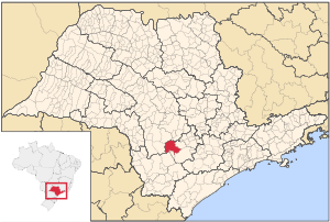
Angatuba
Municipality in the state of São Paulo in Brazil
Distance: Approx. 64 meters
Latitude and longitude: -23.49027778,-48.41277778
Angatuba is a Brazilian municipality in the state of São Paulo. The population is 25,479 (2020 est.) in an area of 1028 km². The highway Rodovia Raposo Tavares passes south of the city.

Campina do Monte Alegre
Municipality in the state of São Paulo in Brazil
Distance: Approx. 9732 meters
Latitude and longitude: -23.42527778,-48.47722222
Campina do Monte Alegre is a municipality in the state of São Paulo in Brazil. The population is 6,057 (2020 est.) in an area of 185 km2. The elevation is 612 m, 2090 ft.
Angatuba Ecological Station
Conservation agency
Distance: Approx. 9787 meters
Latitude and longitude: -23.415875,-48.360764
The Angatuba Ecological Station (Portuguese: Estação Ecológica de Angatuba) is an ecological station in the state of São Paulo, Brazil.
Weather in this IP's area
clear sky
23 Celsius
24 Celsius
23 Celsius
23 Celsius
1014 hPa
86 %
1014 hPa
944 hPa
10000 meters
1.5 m/s
1.92 m/s
5 degree
7 %